Criccieth
| Home
| Berwick
St James | Beer
| Looe | Portreath
| Portreath
| Portreath
| Lynton |
Lynton | Rhosilli
| Broadhaven
| Broadhaven
| Devil's
Bridge | Criccieth
| Criccieth
| Criccieth
| Welshpool
| James
& Aaron | Llandogo
| London
| Map |
Click on each picture for a larger View
May 26
 We
woke up to another fantastic sunny day and Felicity swearing that this would be
a day with VERY LITTLE walking. Knowing that the weather could turn foul
anytime, we decided we should go to the top of Snowden first thing. The road
traveled through the cute town of
Bedgellert
, through the
Nantgwynant Valley and then over
Llanberis
Pass.
Mount
Snowden
is easily north
Wales
' biggest
tourist attraction and the presence of tour buses as we pulled into Llanberis
made that abundantly clear. There was a traffic jam full
of cars trying to get into the main
parking lot for the Snowdon
Mountain Railway so
We
woke up to another fantastic sunny day and Felicity swearing that this would be
a day with VERY LITTLE walking. Knowing that the weather could turn foul
anytime, we decided we should go to the top of Snowden first thing. The road
traveled through the cute town of
Bedgellert
, through the
Nantgwynant Valley and then over
Llanberis
Pass.
Mount
Snowden
is easily north
Wales
' biggest
tourist attraction and the presence of tour buses as we pulled into Llanberis
made that abundantly clear. There was a traffic jam full
of cars trying to get into the main
parking lot for the Snowdon
Mountain Railway so 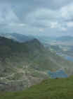 we
swung around the corner and parked down the road at a slightly cheaper Pay and
Display. We arrived at the ticket counter to find out that we were to be given
only 30 minutes at the top and if you missed the scheduled trip down, you could
not be guaranteed a seat for the ride back. A return ticket is £20 and one way
is £14. We stepped out of line just
long enough for the
12:00
train to sell
out. Let's note this. It was Felicity's idea to walk down from the top. I
questioned her multiple times and reminded her of her vow of little walking. She
felt confident that she would be fine and at
11:00
we set our fate
in stone (perhaps
slate) and purchased one way tickets
to the top on the
12:30
train. This gave us time to buy some supplies for the walk (water and
sandwiches to be devoured at the summit) and realize that we had left our rain
gear at the Seaspray. We threw some sweaters in knowing the temperature
difference could be great at the top and arrived early in line for the train.
Take note that your position in line for the train has no bearing on seating
choice and the best way to get a good seat is to push the women, children
we
swung around the corner and parked down the road at a slightly cheaper Pay and
Display. We arrived at the ticket counter to find out that we were to be given
only 30 minutes at the top and if you missed the scheduled trip down, you could
not be guaranteed a seat for the ride back. A return ticket is £20 and one way
is £14. We stepped out of line just
long enough for the
12:00
train to sell
out. Let's note this. It was Felicity's idea to walk down from the top. I
questioned her multiple times and reminded her of her vow of little walking. She
felt confident that she would be fine and at
11:00
we set our fate
in stone (perhaps
slate) and purchased one way tickets
to the top on the
12:30
train. This gave us time to buy some supplies for the walk (water and
sandwiches to be devoured at the summit) and realize that we had left our rain
gear at the Seaspray. We threw some sweaters in knowing the temperature
difference could be great at the top and arrived early in line for the train.
Take note that your position in line for the train has no bearing on seating
choice and the best way to get a good seat is to push the women, children 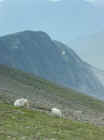 and
little old ladies out of the way as you make a mad dash for the perfect roost.
It also helps if, once through the gate, you proceed to the right about ten
steps, still being prepared to trample all who get in your way. We were stupidly
polite and ended up getting the last two seats on the train, not together. Those
already seated were not only not about to give up their rudely acquired window seats, but no effort was to be made to even adjust their legs to
allow us to pass. I showed a bit of hostility for the whole situation by
accidentally bashing a few people on the head with my backpack full of goodies
and my camera bag.
and
little old ladies out of the way as you make a mad dash for the perfect roost.
It also helps if, once through the gate, you proceed to the right about ten
steps, still being prepared to trample all who get in your way. We were stupidly
polite and ended up getting the last two seats on the train, not together. Those
already seated were not only not about to give up their rudely acquired window seats, but no effort was to be made to even adjust their legs to
allow us to pass. I showed a bit of hostility for the whole situation by
accidentally bashing a few people on the head with my backpack full of goodies
and my camera bag.
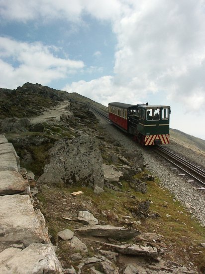
 The
train to the top has you packed in like sardines and if you have any desire to
snap off some pictures, you will probably be disappointed especially if you don't
land one of the coveted window seats. There are two stops along the way and you
can open a window and lean out to take a picture, but otherwise, it's hard to
get much photographic freedom. Felicity also noted that it's a good thing to
face up the hill on the train instead of backwards because, as you climb,
staying in your chair is a challenge. The train ride is an hour each way with
some recorded commentary
going on, much of which you can't hear because of train noise. It helps a bit if
you are directly under the speaker.
All that said, the hike to the top
would be a chore and the train
is a good option if you
want to eliminate pain from your legs.
The
train to the top has you packed in like sardines and if you have any desire to
snap off some pictures, you will probably be disappointed especially if you don't
land one of the coveted window seats. There are two stops along the way and you
can open a window and lean out to take a picture, but otherwise, it's hard to
get much photographic freedom. Felicity also noted that it's a good thing to
face up the hill on the train instead of backwards because, as you climb,
staying in your chair is a challenge. The train ride is an hour each way with
some recorded commentary
going on, much of which you can't hear because of train noise. It helps a bit if
you are directly under the speaker.
All that said, the hike to the top
would be a chore and the train
is a good option if you
want to eliminate pain from your legs.
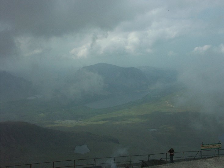
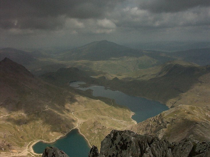
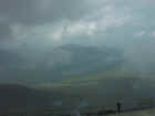 The
view at the top is awe inspiring. Mt. Snowdon's peak can be covered in clouds
much of the time and as we arrived at the top, wisps of clouds passed the peak
just to the South. To the north it was perfectly clear. I went out on a ledge
and took some pictures and then we took the short climb to the very top which
allowed as a view in all directions. We lingered for a while and then sat down
and ate our sandwiches while a class full of kids on a very cool field trip
dined with us. The good news was that they were taking the more difficult trail
down an we would not have to contend with them on our decent.
The
view at the top is awe inspiring. Mt. Snowdon's peak can be covered in clouds
much of the time and as we arrived at the top, wisps of clouds passed the peak
just to the South. To the north it was perfectly clear. I went out on a ledge
and took some pictures and then we took the short climb to the very top which
allowed as a view in all directions. We lingered for a while and then sat down
and ate our sandwiches while a class full of kids on a very cool field trip
dined with us. The good news was that they were taking the more difficult trail
down an we would not have to contend with them on our decent.
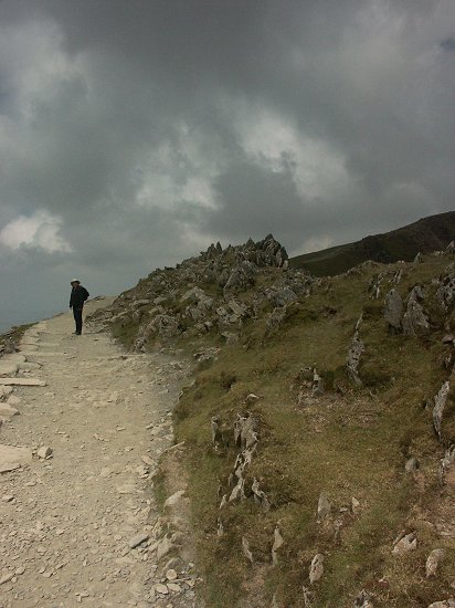
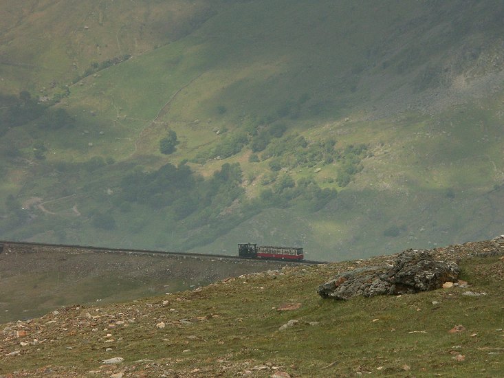
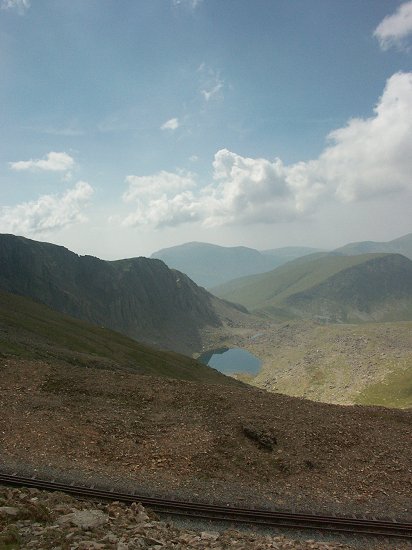
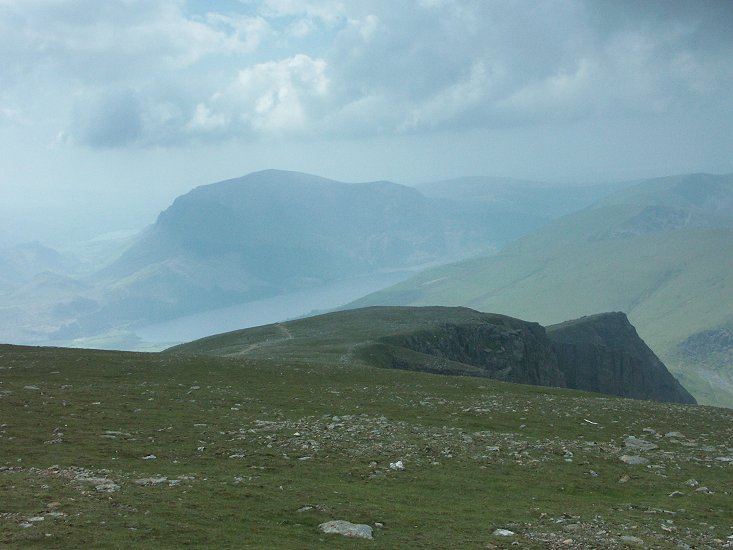
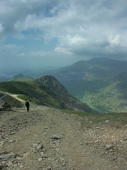
The
easiest path down, and the one that would lead us back to the car follows the rail
tracks to
the bottom. Although, the first
thought is that you've already seen it, you haven't because the trail allows so
much more 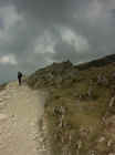 time
and finds itself with some different views. Just below the top, the trail
becomes very steep and the loose slate surface makes it a bit treacherous. It
becomes easier after a while but the trail can always be slick as Felicity found
out the hard way when she slid down the hill feet first which would have been
hilarious if I had done it. I instead showed the appropriate amount of concern
and the temporary fear that Flight
for Life
would have to be called in to get her off the mountain. She was fine though.
time
and finds itself with some different views. Just below the top, the trail
becomes very steep and the loose slate surface makes it a bit treacherous. It
becomes easier after a while but the trail can always be slick as Felicity found
out the hard way when she slid down the hill feet first which would have been
hilarious if I had done it. I instead showed the appropriate amount of concern
and the temporary fear that Flight
for Life
would have to be called in to get her off the mountain. She was fine though.
There is a
"Halfway House" not surprisingly at the halfway point which was closed
and 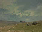 from
what I could tell from the brief bit of commentary on the train has either been
sold or is up for sale. Unfortunately, they were closed and thus no toilets.
Indeed, there
are no trees for about 80% of the hike so the presence of natural toilets is
also absent. As you near the bottom, you leave the trail and follow paved roads.
We thought that sounded good until we realized that they too were very steep Steps
would have been much easier. The last little bit was the most tiring. I knew I
would be a bit sore the next morning and I feared Felicity would be
incapacitated. The hike was listed at 2 hours and at a brisk pace, that could be
achieved. We did it in about 2.5
from
what I could tell from the brief bit of commentary on the train has either been
sold or is up for sale. Unfortunately, they were closed and thus no toilets.
Indeed, there
are no trees for about 80% of the hike so the presence of natural toilets is
also absent. As you near the bottom, you leave the trail and follow paved roads.
We thought that sounded good until we realized that they too were very steep Steps
would have been much easier. The last little bit was the most tiring. I knew I
would be a bit sore the next morning and I feared Felicity would be
incapacitated. The hike was listed at 2 hours and at a brisk pace, that could be
achieved. We did it in about 2.5
We hobbled
back to the Bad Idea and decided to drive to Bedgellert (the long way) for
dinner. We settled in at the Prince LLewelyn and had another fine meal. When we
arrived home, I offered to throw Felicity over my shoulder to carry her up the
stairs. She declined.
Click on each picture for a larger View
|
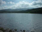
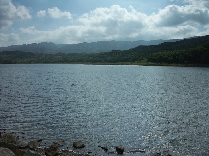
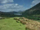
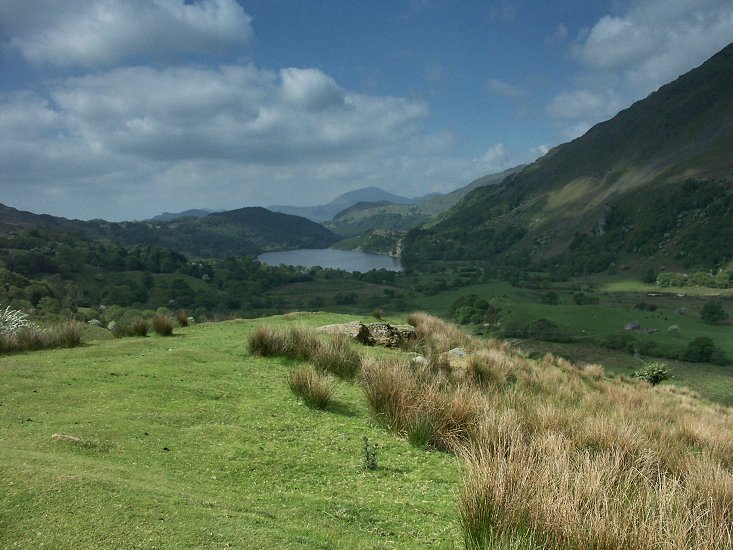
A lake near Bedgellert
|
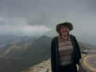
Felicity at the top of Snowdon
|
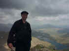
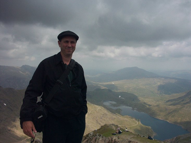
Bill at the top of Snowdon
|

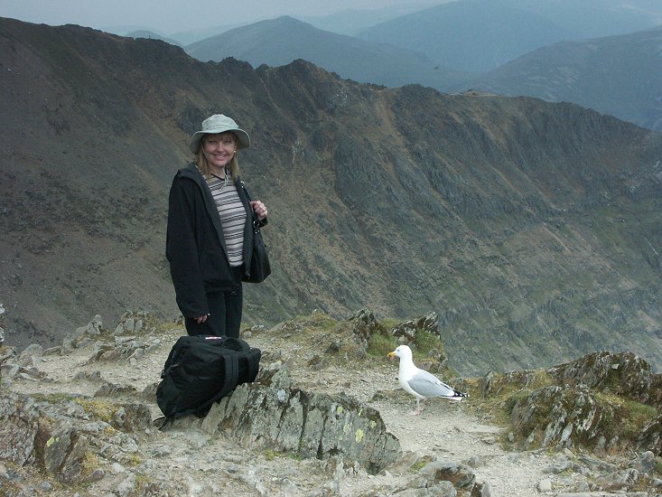
Felicity talks with the birds on Snowdon
|
|
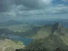
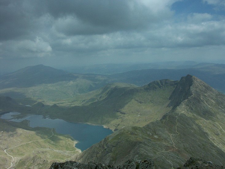
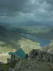
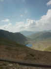
The view from the top
|
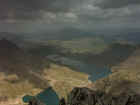
More of the view from the top
|
Optional
routes down in the distance |
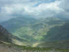
 Looking
across the tracks at the view Looking
across the tracks at the view |
|

More of the view from the trail |
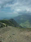 Flicity
in the distance on the trail Flicity
in the distance on the trail
|
The view of Llanberis Pass from above |
| Home
| Berwick St
James | Beer
| Looe | Portreath
| Portreath
| Portreath
| Lynton |
Lynton | Rhosilli
| Broadhaven
| Broadhaven
| Devil's
Bridge | Criccieth
| Criccieth
| Criccieth
| Welshpool
| James
& Aaron | Llandogo
| London
| Map |
[ Back ] [ Next ]
 We
woke up to another fantastic sunny day and Felicity swearing that this would be
a day with VERY LITTLE walking. Knowing that the weather could turn foul
anytime, we decided we should go to the top of Snowden first thing. The road
traveled through the cute town of
We
woke up to another fantastic sunny day and Felicity swearing that this would be
a day with VERY LITTLE walking. Knowing that the weather could turn foul
anytime, we decided we should go to the top of Snowden first thing. The road
traveled through the cute town of 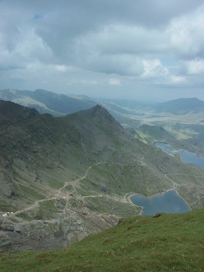 we
swung around the corner and parked down the road at a slightly cheaper Pay and
Display. We arrived at the ticket counter to find out that we were to be given
only 30 minutes at the top and if you missed the scheduled trip down, you could
not be guaranteed a seat for the ride back. A return ticket is £20 and one way
is £14. We stepped out of line just
long enough for the
we
swung around the corner and parked down the road at a slightly cheaper Pay and
Display. We arrived at the ticket counter to find out that we were to be given
only 30 minutes at the top and if you missed the scheduled trip down, you could
not be guaranteed a seat for the ride back. A return ticket is £20 and one way
is £14. We stepped out of line just
long enough for the 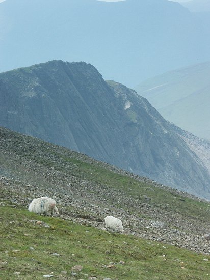 and
little old ladies out of the way as you make a mad dash for the perfect roost.
It also helps if, once through the gate, you proceed to the right about ten
steps, still being prepared to trample all who get in your way. We were stupidly
polite and ended up getting the last two seats on the train, not together. Those
already seated were not only not about to give up their rudely acquired window seats, but no effort was to be made to even adjust their legs to
allow us to pass. I showed a bit of hostility for the whole situation by
accidentally bashing a few people on the head with my backpack full of goodies
and my camera bag.
and
little old ladies out of the way as you make a mad dash for the perfect roost.
It also helps if, once through the gate, you proceed to the right about ten
steps, still being prepared to trample all who get in your way. We were stupidly
polite and ended up getting the last two seats on the train, not together. Those
already seated were not only not about to give up their rudely acquired window seats, but no effort was to be made to even adjust their legs to
allow us to pass. I showed a bit of hostility for the whole situation by
accidentally bashing a few people on the head with my backpack full of goodies
and my camera bag.