 |
 |
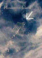
Left: NASA Photo STS008 Date Taken: 09/05/83 Right: UNESCO

 Air Photo of Henderson Island |
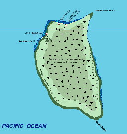
 Henderson Island is an
unihabitated raised reef island, 9.6 km long by 5.1 km wide with
an area of 36 square km, in the Pitcairn Island group of the SE
Pacific. The island's perimeter is 26.4 km; of this, 16.5 km is
encircled by a fringing reef. It is 168 km ENE of Pitcairn.
Henderson Island is the largest island in the Pitcairn Island
group, one of the remotest groups of islands in the South
Pacific, with no major land mass within a 5,000km radius. The
group comprises four islands, with Henderson lying 200km
east-north-east of Pitcairn, 200km east of Oeno and 360km west of
Ducie. Only Ducie, and the Chilean islands of Rapa Nui (Easter
Island) and Sala y Gomez lie further to the east within
Polynesia. The Pitcairn group is a Dependent Territory of the
United Kingdom governed by the British High Commissioner in New
Zealand, and a 10 member island council of H.M.S. Bounty
descendants on Pitcairn Island. Henderson Island is (British)
Crown Land.
Henderson Island is an
unihabitated raised reef island, 9.6 km long by 5.1 km wide with
an area of 36 square km, in the Pitcairn Island group of the SE
Pacific. The island's perimeter is 26.4 km; of this, 16.5 km is
encircled by a fringing reef. It is 168 km ENE of Pitcairn.
Henderson Island is the largest island in the Pitcairn Island
group, one of the remotest groups of islands in the South
Pacific, with no major land mass within a 5,000km radius. The
group comprises four islands, with Henderson lying 200km
east-north-east of Pitcairn, 200km east of Oeno and 360km west of
Ducie. Only Ducie, and the Chilean islands of Rapa Nui (Easter
Island) and Sala y Gomez lie further to the east within
Polynesia. The Pitcairn group is a Dependent Territory of the
United Kingdom governed by the British High Commissioner in New
Zealand, and a 10 member island council of H.M.S. Bounty
descendants on Pitcairn Island. Henderson Island is (British)
Crown Land.
The Pitcairn Islanders visit Henderson Island occasionally to collect miro wood (Thespesia populnea) for curio-making.
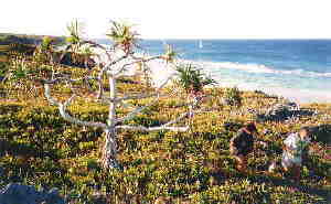
The only other visitors to Henderson Island are scientists visiting this UNESCO World Heritage Site, known for it's endemic species of birds and plants in a near pristine system.
Henderson lies in the south-east trades, and total recorded rainfall for the period from February 1991 to January 1992 was 1623mm. Average monthly maximum temperature, during the same period, ranged from 29.6°C (February) to 24.2°C (June); average monthly minimum temperature ranged from 22.2°C (February) to 15.7°C (June).
Steve Waldren (Botanic Garden Curator/Administrator), Trinity College Botanic Garden, Dublin, who spent three months on Henderson Island in 1991 (and who returned to the island in June 1997), has sent the following comment:
While the Polynesians and later visitors have had some effect on the island, particularly bird populations, the vegetation of the island interior is almost entirely undisturbed. It should remain that way. While it is obvious that many folk would like to visit this exotic and wonderful island, it could easily be inadvertently damaged by visitors, the major threat being the introduction of non-native plants and animals. For example, it is well known that the non-native Polynesian Rat has a massive effect on the breeding success of various petrel species. You might also point out that visitors to Henderson must have permission of the Pitcairn Island Council.
 |
Detail of a new colour map of Henderson Island. Click here to see the full sized version. This map has been made especially for this website by Jean-Pierre Langer of the Principality of Monaco.
Jean-Pierre Langer of the Principality of
Monaco has made a collection of very detailed colour maps,
especially for this website, based upon Admiralty charts. They
can be seen in the links in this section in gif format, and are
also available for download from this site in Adobe PDF format
(requires Adobe Acrobat 3.0 or greater). The PDF format maps have
much more detail than the maps in .gif format. The PDF files are
also available for download in English and French versions from
the links below.
|
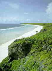
New
Photo of Henderson Island taken June 1997 by John and Lynn Garry Salmon
Read about John Salmon's visit to Henderson
Island June 12-15, 1997
It feels like we are discovering the place for the first time. Of course many (well, at least a few) other people have been here, but right now, we're the only people for hundreds of miles, and we may be the only people to visit this particular part of the island for many months or years.
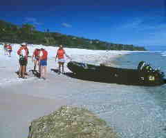
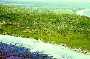
Landing on Henderson Island.
 John and Jean Frazier visited Henderson,
Oeno, Ducie and Pitcairn Islands in April of 1998. They have written a
report of their visit - including many illustrations! Read their story! This is a unique
opportunity to see photos from Ducie Island!
John and Jean Frazier visited Henderson,
Oeno, Ducie and Pitcairn Islands in April of 1998. They have written a
report of their visit - including many illustrations! Read their story! This is a unique
opportunity to see photos from Ducie Island!
Henderson Island during a
storm.
All the pictures I have previously seen of Henderson Island are
in lovely sunshine. A tropical paradise. But, Ina Koys has sent me a picture
taken last year onboard the British brigantine Eye of the wind
which tells a very different story! See this picture!
Oeno Island. Ina Koys has sent me a series of
pictures of Oeno Island. See what Ina Koys describes as the
Pitcairner's Holiday Camp.
Visit Oeno Island! Slide show of pictures from Oeno Island
Visit Oeno Island! Ina Koys' description of her visit to Oeno Island
The Wreck of the Clipper Wildwave
on Oeno Island in 1858. Read the Diary of Capt. Josiah N. Knowles!
An interesting footnote to the
history of the Pitcairn Islands: The island group is named for
the son of the man involved in the shot heard round the
world incident - the first Battles of the American
Revolution! Other revolutionaries, who also fought
against British injustice, then populated this island: The Bounty
Mutineers!

New
information about the skeletons found on Henderson Island in
1958!


"Robert Tomarchin, a 27-year-old U.S. citizen and his pet
ape Moko" - in 1957 .
Photo courtesy of Dr. Herbert Ford , of the
Pitcairn Islands Study
Center at
Pacific Union College.
The Monkey Story: Read the true story of Robert Tomarchin and his chimpanzee Moko. They were left on Henderson Island by a Canadian yacht in 1957!

Click below to link other Pacific Islands sites |
|---|
| Join Skip Prev Prev Next Skip Next Next 5 List Sites |
This website is maintained by:
Mark Winthrop, Copenhagen Denmark
Contact:
![]()