 Contents Casio Digital Diaries Capt. James Cook Henderson Island Information about Denmark Life on Mars? Lockheed P-38
Contents Casio Digital Diaries Capt. James Cook Henderson Island Information about Denmark Life on Mars? Lockheed P-38


 The Pacific Islands Pilot describes Henderson island as "bounded by perpendicular cliffs of dead coral, about 15m (50 ft.) high, considerably undermined by the sea. They rise to a flat surface about 30m (100m) high. Trees and dense undergrowth cover the surface, except near South Point, the S extremity."
The South Pacific Handbook describes: " The interior of the island is a flat coral plateau about 30 m high but the dense undergrowth, prickly vines, and sharp coral rock make it almost impenetrable."
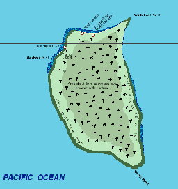
Henderson is an elevated coralline limestone ("makatea") island which rises as an isolated conical mound from a depth of about 3.5km. The surface of the island is coral reef-rubble interspersed with areas of dissected limestone, surrounded by steep limestone cliffs undercut on all sides except to the north. There are three main beaches, to the north, north-west and north-east. Tidal range at spring tides is probably about 1m, and tides are semi diurnal. The central depression is considered to be an uplifted lagoon. Freshwater is almost completely absent, only occurring as drippings in caves, and as a spring below high tide level in the north (flow and permanence unknown). The geology of the island is limestone from the late Tertiary age. It is also suggested that much of the inland topography may be karst features.
|
Makatea Islands: All Pacific Islands (this was Darwin's discovery) are volcanic islands. Islands like Hawaii, Pitcairn and Tahiti etc. are peaks of huge undersea volcanoes. Some volcanic islands had a short existence. The central part of the island eroded and subsided while the surrounding coral reef grew. These are atolls. The lagune is the remnant of the original volcano. A few islands - Makatea was the first described and has given it's name to the type - are the result of the lagune, now covered by generations of coral growing there, rising again due to geological/volcanic activity. Henderson is this type of island - the lagune and it's surrounding reef raised from the ocean, and a new reef began to grow. The center of the island is the remains of the lagune - this is easily distinguished by different fossil coral remains.
Rossman P. Irwin III a geologist, who is organizing a project to put up a permanent climate station on Ducie to study atmospheric, surface, and oceanographic data from this remote region, has sent the following comment:
I suppose you have read about the geology at Henderson, and why it is such an odd place. Geologically, the island is made possible by the coincidence of two mantle hotspots similar to the one that built Hawaii. They are not close together, but the Pacific plate is moving almost in line with the two, so the lines of islands they produce are about 60 or so miles apart. Henderson is uplifted by the weight of several large undersea marine volcanoes which are situated to the south-east of Pitcairn and are presently being built by the Pitcairn hot-spot. The large ones are named Adams, Young, and Bounty, and deeper ones are named Pitcairn 1,2, etc. Adams reaches within 60 feet of the surface, and may have been exposed during the recent Ice Age. The weight of these depresses the crust beneath them and produces a slight circular elevation at some radius, and Henderson is in the right place at the right time. The discovery of these is referenced in some recent papers.
Pacific Island Pilot: "Good fresh water has been found at the N end of Henderson island, running from a cleft in the rock at half-ebb tide, but not visible at high water....Another source of supply is on the N coast about 1 mile from the NW point of the island, spouting from the roof of a low cave situated just above high water mark." This cave is known as Lone Frigate Cave and has been the site of archaeological excavations.
The island has a spectacular surrounding reef at low tide, upon which it is possible to walk for hundred of yards from the beach. This fringing reef is at least 200m wide to the north, north-west and north-east sides of the island, backed by a wide beach. Reefs off the north and north-east beaches are seawardly sloping reef platforms without reef crests, and are not typical fringing reefs. Coral cover is about 5%, dominated by Pocillopora with Millepora becoming dominant at depths greater than 7m. Submassive Acropora colonies are also present on the buttresses and solid substratum. In total, 19 genera and 29 species of coral were collected in 1987. There are two narrow channels through the reef on the north and north-western coasts.

 Henderson's History Henderson's History
| Henderson's Geography
| Henderson's Flora and Fauna
|
| Why am I interested?
| First hand accounts.
| Links and Books.
|
| Map of the Island.
| Pictures of the Island.
| The Monkey Story
|


New information about the skeletons found on Henderson Island in 1958!


The Monkey Story: Read the true story of Robert Tomarchin and his chimpanzee left on Henderson Island by a Canadian yacht in 1957! New information has also come to light and is now presented here.


