

PORT ELIZABETH DIVISIONAL COUNCIL / AFDELINGSRAAD PORT ELIZABETH
Province/state: Cape Province (before 1910, Cape Colony / now Eastern Cape).
Separated from Uitenhage in 1848
Incorporated into: 1978 Dias Divisional Council (1987 Algoa Regional Services Council [1994 Western District Council]).
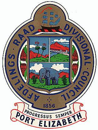
The arms may be blazoned:
Per fess: I: per pale: i: two aloes (Aloe ferox); ii: the Gamtoos River bridge (seen from the left bank of the river) with a Kouga mountain peak behind; II: an Addo elephant standing between two prickly pear cactuses.
Crest: a three-masted ship proper in full sail azure, the main mast flying a pennant gules.
Crest-wreath: gules and sable.
Motto: Progressus Semper.
Although not mentioned in the blazon, all three landscapes have grassy foregrounds, red mountains behind and white clouds in the sky.
There are white fimbriations between the three divisions of the shield. The shield has a gold border, but this would appear to be merely decorative, as is its blue fimbriation.
On either side of the shield, in the gap created by the circular outside border bearing the legend “Afdelings Raad”, “Divisional Council”, is a pair of sugarbush protea flowers (Protea repens), the upper one in each case inverted. (The drawing is so poor that it is hard to identify the species; the flowers could possibly be intended to be the woolly-bearded or neriifolia protea [P neriifolia], also called the blousuikerbos.)
The motto translates as: “We always progress.”
The arms are rather unheraldic in origin, and were probably never officially registered. The arms were nonetheless used by the council.
Arms explained:
The sugarbushes represent the fynbos flora of Port Elizabeth. The fynbos biome, by far the larger and more diverse of the two biomes making up the Cape Floral Kingdom, stretches from the Albany district to the Cape Peninsula and northwards to Nieuwoudtville; P repens is found in a large proportion of this countryside. The Cape Floral Kingdom is the smallest geographically of the world’s floral kingdoms, but the richest in species variety.
The aloes (Aloe ferox) are a further striking example of the flora of this region, although they are not presented well in this example.
The prickly pears (Opuntia ficus-indica) are exotic flora that are no longer regarded as characteristic of the region.
The elephant appears to represent the Addo Elephant National Park, which in fact falls outside the old Port Elizabeth Division – it in fact lay in the (then) Alexandria Division. Elephants are traditionally associated with arms in Port Elizabeth because the City Council had one – in fact an Indian elephant, derived from an augmentation of honour in the arms of the town’s founder, Sir Rufane Donkin.
The ship crest appears to imitate that of the city as well.
The colours of the wreath, too, are unheraldic (because there is insufficient contrast between red and black), although these are the traditional sporting colours of the Eastern Province (the eastern part of the Cape Colony, between the Fish River and the Tsitsikamma, but today the western half of the Eastern Cape).
About the division:
Port Elizabeth acquired its own civil division in 1848 when it was separated from Uitenhage. However, this covered a relatively small area stretching from the Swartkops River to Kuyga and Draaifontein, and including Seaview on the coast and what would become Walmer.
The divisional council came into being in 1856, a year after the passage of the Divisional Councils Act, because of uncertainty concerning the council and its area of responsibility.
This area was enlarged three times during the council’s lifetime, each time the result of disagreement over its revenues, since the tiny Port Elizabeth Division collected far more (in both tolls, abolished in 1910, and local taxes) than either the Uitenhage or Alexandria divisions. In 1906 a small area along the Uitenhage road was added, south of the Swartkops River, and in 1930 the division was extended to the Sundays and Gamtoos rivers, so that the Port Elizabeth Division now bordered on the divisions of Humansdorp (in the west) and Alexandria (in the north). In 1949 the small district of Hankey was added to the Port Elizabeth Division as well.
The arms could have been devised at any time between 1930, when the Gamtoos River bridge became the responsibility of this council, and 1956, when the Port Elizabeth Divisional Council marked its centenary by publishing a book illustrating the arms. Ironically, the bridge was built by the divisional councils of Uitenhage and Humansdorp, because in 1895 when it was erected the Gamtoos River was nowhere near the Port Elizabeth Division.
The Port Elizabeth Divisional Council disappeared into larger groupings after 1978. However, the local government election of 2000 saw the area once covered by the council (minus Hankey) incorporated into the Nelson Mandela Metropole, and in fact making up the largest proportion of the metropolitan area.

Comments, inquiries: Mike Oettle