

DIAS DIVISIONAL COUNCIL / AFDELINGSRAAD DIAS
Province: Cape Province.
Formed: 1978, incorporating: Port Elizabeth Divisional Council, Uitenhage Divisional Council, Alexandria Divisional Council, Bathurst Divisional Council.
Additions: Albany Divisional Council, 1980.
Incorporated into: 1987 Algoa Regional Services Council (1994 Western District Council).
Bartolomeu Dias
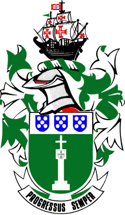
The arms may be blazoned:
Arms: Vert, a padrão argent; upon a
chief argent, three quinas or escutcheons azure, each charged with five
plates (or roundels argent), 2, 1 and 2.
Crest: Upon a wreath argent and vert, a caravel proper, its sails
charged with the cross of the Order of Christ, with flying from its masthead a
banner of the arms of King João II of Portugal, and from the foremast a pennant
vert.
Motto: Progressus semper.
About the arms:
This device strongly reflects the discovery[1] in 1488 of the coastline – which between 1978 and ’87 formed the southern boundary of the division – by the Portuguese explorer Bartolomeu Dias.[2]
The crest shows his vessel the São Cristóvão, a typical caravel as used at the time in Portuguese voyages of exploration. All exploration along the African coast was undertaken by the Portuguese Order of Christ,[3] hence the appearance of its characteristic red cross on the white sails of the vessel. Dias was sailing under the authority of King João II (*1455 †1495, king from 1481), and so flew a banner of the royal arms as his national flag.[4]
The principal charge in the arms is a padrão of white stone. Portable monuments of this type were carved in Portugal prior to the departure of exploratory fleets so that they could be erected on the African coast to mark the progress of the fleet and to establish a claim to the Portuguese king’s authority over the coast so marked.
There are various types of padrão, as the particular style of carving them changed through the 15th century, but they typically bore a tablet carved with the royal arms, and above it a cross. The padrão shown in these arms is an exact replica of the two padrãos carved in Portugal in the late 20th century for erection in the environs of Algoa Bay; it is quite likely that the padrão actually erected along this stretch of coast in 1488 was somewhat different.
The green field reflects the verdant coastlands incorporated into the division, which stand in sharp contrast to the much drier interior of this part of the country.
The chief (the top part of the shield) imitates the arms of Portugal.
This royal house is a branch of the Capetian family which provided kings of France from AD 987 to 1848. Between 1003 and ’06 King Robert II of France conquered the Duchy of Burgundy and made his son Robert duke of that realm. Robert of Burgundy’s son Henri (Enrique) took service under the King of Castile, who in 1093 married him to his illegitimate daughter Teresa and made him Count of Portugal (the district around Oporto).
In 1139 Count Enrique’s son Afonso proclaimed himself King of Portugal, and in 1143, under papal pressure, he was recognised as king by Castile.
The earliest arms borne by the House of Portugal were a silver shield charged with a blue cross. It would appear that the cross was made of blue leather, fixed in place with silver nails, since the cross became damaged in battle and eventually comprised five separate pieces of blue leather, each fixed with several silver nails.
Eventually the arms were formalised as argent, five escutcheons azure, each charged with several plates. A plate is a silver roundel; the number of plates gradually came down from nine to five, arranged 2, 1 and 2.
Various fanciful explanations were given for these arms, the leather cross having been forgotten, and one of the most popular entailed counting the plates on each shield 1, 2 3, 4, 5, 6 (counting the middle one twice), giving a total of 30. It was then said that these were the 30 pieces of silver with which Judas betrayed Christ.
The blue shields, each with its (eventually) five plates, were known as the quinas.[5]
In these arms there are three quinas instead of the five that properly make up the royal arms; in this way they allude to Portugal without making any claim to any stronger connection with that country.
The motto, Progressus semper (We always progress), is taken directly from the arms of the Port Elizabeth Divisional Council.
Bartolomeu Dias:
Little is known of the early life of this remarkable explorer, “usually considered the greatest of the Portuguese pioneers who explored the Atlantic in the 15th century”.[6]
There is no proof for the claim that he was descended from one of Henry the Navigator’s pilots, and in rank he was no more than a squire in the royal household. The extended surname Dias de Novais appears in no contemporary documents, and is first found in the deed of appointment of his grandson as governor of Angola in 1571.
In 1486 King João II sent two men, Pêro da Covilhã and Afonso Paiva, overland to India and to Ethiopia and also ordered Dias to find the southern limit of Africa. In part this was motivated by fresh rumours of the legendary Prester John which reached Europe in that year.
Indeed, “Prester John” had formed part of the motivation behind the entire exploration of the African coast, since Henry the Navigator had cherished the dream of forming an alliance with a Christian ruler against Islam.
This legend had its factual beginnings with the Mongol khan Yeh-lü Tach-shih, Buddhist founder of the Karakitai empire in Central Asia, who had Nestorian[7] advisers, and who defeated the Seljuq sultan Sanjar in a battle fought at Qatwan, in Persia, in 1141.
The Karakitai ruler’s title was Gur-khan, which by translation through two or three Middle Eastern languages became the Hebrew Yochanan, or John. By the time reports of the Qatwan battle had attained general currency in Europe, however, it was being said that the ruler of the state was a Christian and his name was John.
Several decades later, the legend had transferred itself to India, where, it was said, Prester John’s grandson, named David, had defeated the Muslims in that subcontinent. This version of the story may have been based on the Mughal dynasty which arose in Central Asia, and which converted to Islam only after rising to power in India.
In the long run the legend attached itself to Ethiopia, where it was generally known that the ruling dynasty was Christian. However, even in this version the legend was divorced from the reality, since the king was also supposed to be a priest, hence the appellation Prester John.[8]
Dias’s fleet comprised three vessels, São Cristóvão, commanded by Dias himself; the São Pantaleão, under his associate João Infante; and a supply ship commanded by Dias’s brother, whose name appears as either Pêro or Diogo. Included in the company were several prominent pilots, notably Pêro de Alenquer and João de Santiago.
Even the year of Dias’s departure is in dispute, since the 16th-century historian João de Barros dates it as being in August 1486, but it is now generally accepted that it was in August 1487.
The fleet passed the padrões erected by Diogo Cão on the Congo (or Zaïre) River and at Cape Santa Maria (now in southern Angola) in 1482 and the one he had erected at Cape Cross (now in Namibia, north of Walvis Bay) in 1486 and on 8 December reached Walvis Bay. On 26 December they reached Elizabeth Bay (which he named the Golfo de São Stefano, [9] south of present-day Lüderitz).
After 6 January 1488 Dias was prevented by storms from sailing near the coast, and was then out of sight of land for some days. When he turned eastwards again, he found no land, and only after turning north did he sight land on 3 February. He landed at what he called Angra de São Brás (having landed there on St Blaise Day) or the Angra des Vaqueiros[10] (Bay of Cowherds), which is now known as Mossel Bay.
They sailed on to Angra de Roca (Bay of the Rock, now called Algoa Bay), where a wooden cross was erected on an island which Dias recorded as Santa Cruz.[11] The crew was unwilling to continue, and the officers were unanimously in favour of returning. However, Dias obtained their agreement to continue for a few days, and they reached the Rio de Infante (which Dias named after João Infante), which was probably the Fish River.[12]
A padrão, which Dias called the padrão de São Gregorio, was erected just to the east of Algoa Bay at a place now known as Kwaaihoek. Early in the 19th century Boer farmers destroyed this cross as a symbol of Roman Catholicism.
On the return voyage Dias sighted and named the Cabo de Bõa Esperança (Cape of Good Hope), although on his return this name was credited to King João and it was recorded that Dias had “named” it Cabo Tormentoso (Cape of Storms).
In 1986-87, to mark the 400th anniversary of Dias’s voyage, an exact replica of the São Cristóvão was built in Portugal and sailed during 1987 and ’88 in a re-enactment of that voyage. The vessel was tied up at a quay in the Port Elizabeth harbour during what was called the Dias Festival for visitors to inspect her. She was also sailed as far as the Fish River, making calls along the way at St Croix island (renamed Santa Cruz for the occasion) and Kwaaihoek.
About the council:
The high costs of rural administration forced the Cape Provincial Administration during the late 1970s to merge a number of divisional councils.
In the Algoa Bay region it was the divisions of Port Elizabeth, Uitenhage, Alexandria and Bathurst[13] that formed a single council in 1978, so effectively controlling the coast from the Gamtoos River to the Fish. The council was based in Port Elizabeth.
In 1980 the Albany Division (based in Grahamstown) was also merged into the Division of Dias.
Under a new provincial ordinance, the Dias Divisional Council became the Algoa Regional Services Council in 1987.
