![]()
![]()
![]()
![]()
![]()
![]()
|
|
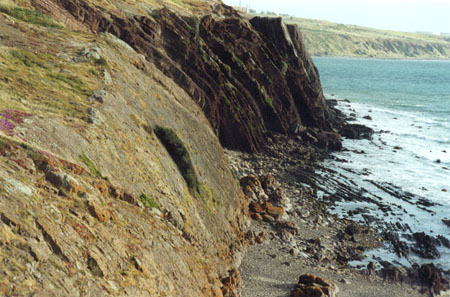
This page is headed "A Gap in Time", because this time elapse is clearly visible in the photograph of the wave-cut platform and in the photograph of the cliff. (If you have difficulty reading the information from the photograph of the sign I have retyped it below.)
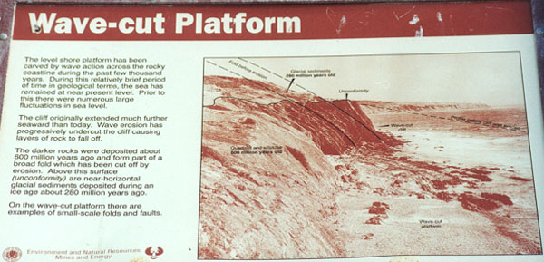
The level shore platform has been carved by wave action across the rocky coastline during the past few thousand years. During this relatively brief period of time in geological terms, the sea has remained at near present level. Prior to this there were numerous large fluctuations in sea level.The cliff originally extended much further seaward than today. Wave erosion has progressively undercut the cliff causing layers of rock to fall off.The darker rocks were deposited about 600 million years ago and form part of a broad fold which has been cut off by erosion. Above this surface (unconformity) are near-horizontal glacial sediments deposited during an ice age about 260 million years ago.On the wave-cut platform there are examples of small-scale folds and faults.The description above was clearly visible as may be seen in the following photograph.
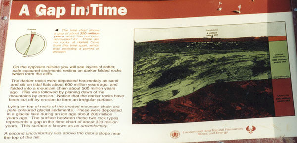
(If you have difficulty reading the information from the photograph of the sign I have retyped it below.)
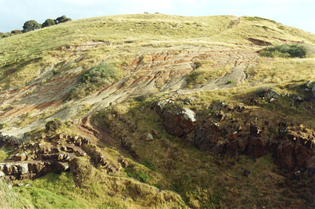
Information next to the pie chart:The time chart shows a gap of about 320 million years which has not been accounted for. There are no rocks at Hallett Cove from this time span which was probably a period of erosion.Typing next to the sign's photograph:On the opposite hillside you will see layers of softer, pale coloured sediments resting on darker folded rocks which form the cliffs.The darker rocks were deposited horizontally as sand and silt on tidal flats about 600 million years ago, and folded into a mountain chain about 500 million years ago. This was followed by planing down of the mountains by erosion. Notice that the darker rocks have been cut off by erosion to form an irregular surface.Lying on top of rocks of the eroded mountain chain are pale coloured glacial sediments. These were deposited in a glacial lake during an ice age about 280 million years ago. The surface between this two rock types represents a gap in the time chart of about 320 million years. This surface is known as an unconformity.A second unconformity lies above the debris slope near the top of the hill.As you can see from the following photograph this unconformity is really striking, and to amateurs like us the above description gave meaning to what we observed.
|