|
 Virginia Virginia
Mile 0 - Skyline Drive Beginning
Skyline Drive begins in the north at its junction with U.S. 340
south of Front Royal, Virginia. I-66 west meets U.S. 340, 4 miles
north of the city.
Mile 0.6 - Front Royal North Entrance
Front Royal (North) Entrance Station is staffed by National Park
Service personnel who, besides collecting entrance fees, can answer
your questions and give other assistance.
Mile 2.8 - Shenandoah Valley Overlook
Shenandoah Valley Overlook provides a sweeping view across the
valley to Signal Knob, a Civil War communications post to the right on
Massanutten Mountain. The mountain divides the valley and the
Shenandoah River, with the south fork on this side and the north fork
on the far side. The two forks meet north of Front Royal.
Mile 4.6 Dickey Ridge Visitor Center
Dickey Ridge Visitor Center is one of the park's
two major information facilities with exhibits on services and
activities and a sales outlet for publications, slides, and maps.
Picnic ground, 1.3-mile circuit self-guiding nature trail, and, across
the Drive, access to Dickey Ridge Trail.
Mile 6.8 Gooney Run Overlook
Gooney Run Overlook gives a view across the valley
and toward Dickey Ridge on the right.
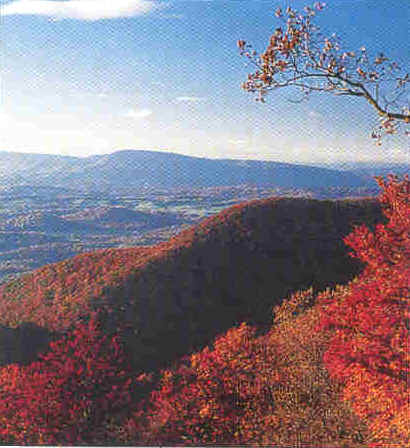
Mile 17.1 Range View Overlook
Range View Overlook offers a spectacular view of a
large section of the Blue Ridge. This overlook, at mile 17.1, offers a
view down the length of the Blue Ridge to Stony Man Mountain. Looking
south from 2,810 feet, the viewpoint stretches from Jenkins Mountains
to Gimlet Ridge, Massanutten Mountain and the Alleghenies beyond.
Mile 17.6 Big
Devils Stairs
Big
Devils Stairs is relatively easy, 5.4 mile round-trip hike
offers great views of Shenandoah National Park. Plus, see a hut used
by long distance hikers when this path crosses the Appalachian Trail.
Mile 21 Hogback Overlook
Hogback Overlook offers, on clear days, a look at
many of the bends of the meandering Shenandoah River. I like this
overlook because it is the longest in the park. You can't take it all
in without getting out of your car or driving a bit to the other end
of the vista. From here, at milepost 20.8, you can see the Shenandoah
River below, the two ridges of Massanutten Mountain and the
Alleghenies. In the foreground is the valley of Overall Run, Mathews
Arm and Gimlet Ridge.
Mile 22.1 Piney River Ranger Station is on the east side of
the Drive. Stop here if you need help.
Mile 24.1 Elkwallow facilities opening varies from year to
year. Check with the park for current information. Picnic ground, food
service, camp store, gasoline, ice, firewood, souvenirs.
Mile 28.5 Beahms Gap provides access to the Appalachian
Trail and shorter trails.
|