
Trails on Bonaparte Mtn in Okanogan County
|
From: Peter On Monday I returned from a long vacation. I had put my bikes in a rented cargo van and hit the road. I had time to investigate the trails on Bonaparte Mtn in Okanogan County, near the town of Tonasket. Bonaparte Mtn is the tallest Mtn in NE Washington (7,200). A Look Out (L.O.) sits at the top. The rangers that live there during the summer have to walk in. There is a trail that (more or less ) encircles the mountain. Several trails cut up from the bottom the connect to it. 1. Fourth of July trail. 12 miles of technical trail (not steep but rocky and twisty) that starts at a pass on the west side and continues eastward around the Mtn to the north side, then connects with the Bonaparte L.O trail. The 4 of July trail is technical. 2. Bonaparte Lake trail. Cuts up the east flank of the Mtn from Bonaparte Lake to the Fourth of July trail. Steep. 4-5 miles. 3. Bonaparte L.O. trail. Starts on the north flank and heads up, connecting with the Fouth of July trail. The Fourth of July trail ends where it connects with this trail. The Bonaparte L.O. trail is the main route hikers use to get to the summit. Steep and rocky. 5 miles. 4. Antoine trail. 7 miles. This trail is similiar to the Red Mtn trail. This trail starts on the north west side about 4 miles from the Fouth of July trail. It connects to the Bonaparte L.O. trail above where the Fourth of July and Bonaparte L.O trails become one. It was cleared last year. Traffic on trails: virtually no one, particularily on the Fourth of July and Antoine trails. The area is fairly removed from population centers. Bonaparte Lake is a popular "resort" area of the primitive kind. Don't expect to see many people. It is also a beautiful and "different" part of the state. |
Back to the Trails.
Or back to the top.
|
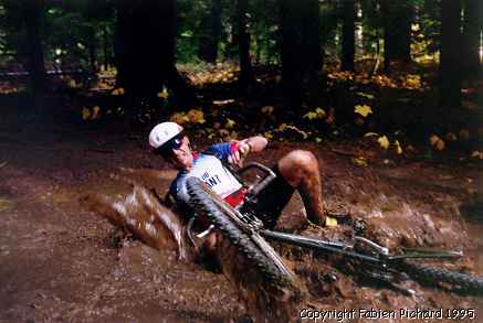
From: Fabien Well, if you like having fun, this one is great. Saturday, I went with my friend Peter to Cashmere in order to have fun on Devils Gulch. That was great fun. The only "problem" is the drive, between 2 and 3 hours. First you have 11.5 miles uphill on a 4X4-Sandy-Logging road THEN, 12 miles down on a single track! Woaaaaohhh, That was a blast. The views were very pretty and the downhill too. There was lot of 'OOOOOPPPPS' !Switchbacks! and don't miss one because you may be still on the trail, but 20 yards down. Oh well, it could be a nice way to learn how to fly... If you want to go there, one thing to know, at 8.7 mile, there is an 6-way intersection (not 5-way), take the logging road on you right, not the jeep road. We got lost with this description because in the book, it says "Go right, continuing climbing on the better of the two road heading uphill..." the jeep road looks better!!! We lost 45 minutes with that mistake. Otherwise, take LOTS of water... For two, we had 12 liters and we had to fill up the bottles at the Cold water creek. Take some protective glasses (yellow type), no sunglasses because the downhill is sometimes too dark, and of course a good helmet. From: Fabien Date: Thursday, September 21, 1995 10:31AM I went there 2 weeks ago and we saw 20 riders!!!! I never met that many people on a trail. They built a big parking spot a the beginning of the trail to accommodate the ones that do not want to climb the first 11.5 miles with their bike. For more info, check out the Devil's Gulch map and log. From: Peter Rode it Sunday from Sand Creek to Tronsen Ridge. The trail is still in pretty good shape----a good rain would firm it up. The dirt is fairly loose on any steep uphill or downhill above the cut off to the Devil's Gulch trail (Red Mtn. Spur) due to motorcycles. The lower part is just fantastic. The open areas can get sandy, though. This is the latest I've ridden it---usually try for mid-June before the motorcycles. Saw no one. Don't forget to get the map of the area! |
Back to the Trails.
Or back to the top.
|
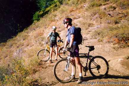
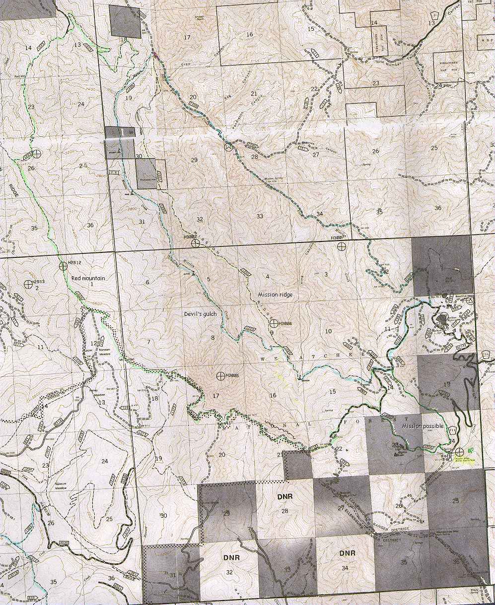
From: Fabien 3 weeks ago, I went to Eastern Washington to try a new trail. I thought I was a good biker, pretty technical, being able to go over almost anything... Well I found the most challenging trail I ever tried. It's called the Rock Garden in the book Washington South Cascade. It's located between Cle Elum and LeavenWorth. It starts in the lower Naenum meadow (FR3035), on Naenum Creek Trail. It climbs for the first 4.8 miles on a steep, rocky, sandy, technical narrow trail. I mean, it's HARD! Very challenging! It goes up along the side of the mountain with not many switch backs, so when you can stop somewhere, trust me you do it! Then you arrive on FR3050 where you have to go for another 1/2 miles before you arrive on the table. There you have a extremely beautiful view on Mont.. Rainier and Mont. Stewart, beautiful... The next 2 miles will be on the forest road before you take the trail going down. At a point, you have to change trail to follow Drop creek trail, DON'T MISS IT! I did and I went down on a super rocky sandy trail, completely lost and I have to come back up for two miles carrying my bike because it was un ridable going up. When you turn on Drop Creek Trail, the first 1/2 miles are pretty nice then you have a Dr. Jekyll to Mr. Hide transformation when you'll find super steep drops. Later you will join the Naenum Creek Trail again and you'll be back to your car... I thought I knew some pretty tough trail, but this one is AWESOME! I'll go back there, for sure! One hint: When you go there, stop at the ranger station and buy the Fire road map, it will be very helpful in case of, like me. you get lost. Also take lots of water, I drank 2.5 camelback during the trip. It's very hot and dusty back there. When we were there, it was the start of the bow hunting season, don't worry you have nothing to fear, I could spot then before they could spot me! I believe the animals are safer with this kind of weapons... Well if you want more infos to get there, it's in the book! You want more? Trail Log! |
Back to the Trails.
Or back to the top.
Angel's Staircase Loop - Methow Valley
|
From: Kai Date: Monday, May 20, 1996 6:17:59 PM Technical Level: ( ) Beginner ( ) Intermediate (*) Totally Tech ( ) Death Wish Elevation: ( ) Relatively flat ( ) Some Uphill but OK (*) Grinder ( ) Cough Up a Lung Open Season: (*) Spring to Fall ( ) Summer Only ( ) Year Around Course Description: Start from the Crater Lake trailhead at 4800 feet altitude. At 0.7 miles take the fork left to Eagle Lake Trail, #431. 1.8 miles farther, take another left fork onto Martin Creek Trail #429. This drops about 400 feet, then climbs up to 7,200 ft Cooney Lake, passing a side trail to Martin Lake. Cooney Lake and its basin are exceptionally beautiful. Larch trees frame the lake amidst rich green meadows and rocky peaks. From Cooney Lake there is a steep side trail heading 800 feet up to the ridgeline above, (This does not appear at all on older maps but is shown as trail #434 on new ones). The top of this trail is a saddle overlooking Merchant's Basin. A side trail forks to the right just beyond the saddle a climbs a short distrance to get to the ridgeline at 8,000 feet. The view from here is tremendous, extending as far as Mt. Rainier to the south. Below a beatiful meadowed valley runs under the north-south headed ridgeline. A steep zig-zagging trail, the Angel's Staircase, connects the ridge with the valley. I fyou can ride all of it, more power to you. The surface is rocky at the top but as it descends there is more soil, and the trail gets increasingly rideable. At the junction below, turn right and head north 2.6 miles on trail #1259 to the Boiling Lake junction. Turn right there, ride up and past Boiling Lake, and climb to Horsehead Pass, 7600 feet. Follow the trail down, down, down, past the junctions for the Eagle Lakes, Martin Lake, and Crate Lake, back to the trailhead. Approach: From Twisp drive south, past Carlton, and turn right on the signed junction for Gold Creek Road. Continue past the South Fork, and Foggy Dew juntions and follow signs to the Crater Lake trailhead. Other Comments: Vertical: 5,000 feet Distance: 25 miles Map: Green Trails, Prince Creek #115 This is the ultimate Methow mt. bike ride. It is a classic by anyone's standards, anywhere. There are 25 miles and 5,000 vertical feet of top quality riding, all on singletrack, in the midst of high peaks, lush green meadows, lakes, and dark forests. The trail is one of the highest snowfree trails in the state, reaching timberline at 8,000 feet. Much of it is smooth and fast, groomed for motorbikes, but some is technically challenging - to the limits of most riders' ability. The long day spent on this route is steadily exhilirating, always changing, and completely satisfying. |
Back to the Trails.
Or back to the top.