|
|
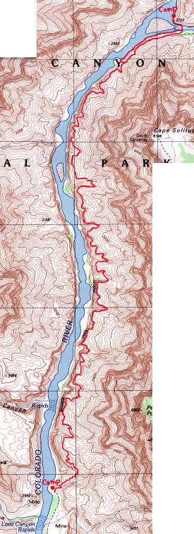
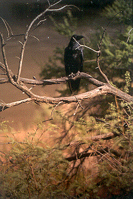
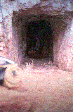
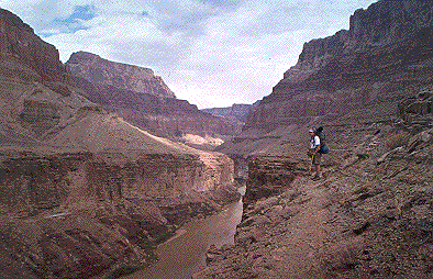
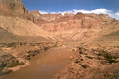
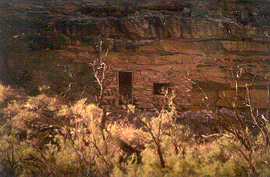
The next morning was cool and cloudy. We got up and took stock of our camp and found nothing out of order. Had there been any wind, it would have been a really uncomfortable. We broke camp and headed down to the river to pump water for our 5 gallon "settling tank". As we pumped our last bottle, the pump clogged. This was half expected as most filters are susceptible to clogging with the slightest sediment. But all was not lost. We had plenty of fuel (we started with over 1 liter) so we boiled water for the last bottle and headed back to the campsite to collect out packs. To our surprise Brothers Raven had paid us a visit. Still perched in nearby trees, they had unzipped the outside pockets of our packs and had strewn the contents everywhere . We scolded them, repacked, and headed out. The trail now headed briefly away from the river and began to ascend what would be a 200 ft cliff. But before we headed up, we decided to check out the mine tailings we had seen the previous afternoon. Instead of hauling our packs back to the mine and returning to the same spot, we dropped them on the trail. The mine was about a quarter mile back against the base of a cliff. It went straight back into the cliff for 50 feet and then made a gentle turn to the left. As the floor was under 6 inches of water and we forgot to take a flashlight from our packs, we didn't go in. It was obviously a copper mine, as we found lots of blue-green colored rocks. Judging from the large amount of tailings, the mine had to be extensive. I took a couple pictures and we headed back to our packs. Fool me once, shame on you. Fool me twice, shame on me! Brothers Raven had emptied our packs again! This time they tore open my Cool-Aid and emptied it on the ground. It was for mixing with the brackish water as we hiked up the LCR. They put about twenty holes in John's ground tarp. We climbed the trail that was the continuation of the Beamer. It was well marked and generally easily followed. The trend of the trail was to follow the shelf at the top of the Tapeets sandstone that contoured in and out of 16 to 18 small canyons. The longest trip in and out of the deepest canyon was probably about 20 minutes, nothing like the hours we spent contouring in and out of Hance Canyon last year... that was a lot like work! If you travel this part of the Beamer, be sure you locate the trail where it leaves each canyon as you enter them. Because of the active erosion, and washouts, it's easy to get off trail in these little canyons. The cliff face below the trail was nearly vertical. One could easily hit the water with a rock. The Tapeets sandstone in this area of the Canyon generally slopes toward the north, the same direction as the trail and as it does so, it slowly descends toward the river. As we proceeded along, I stopped to take some photos while John pushed on putting some distance between us. He came to a fork in the trail, and decided to take the low route. As I came along, he shouted up to me to stay on the high trail as the low one looked like it'll die out between the cliff and river. It didn't and he had a nice walk along the shore. I followed the high path, still about 100 feet above the river. In several areas I found numerous well-rounded boulders, indicating the shelf had once been at river level. We finally made the confluence of the Colorado River and the Little Colorado River taking us about 6 leisurely hours. Looking north, above the confluence we could see the Colorado was considerably less muddy than below. John and I met up just around the corner, upriver on the LCR. My trail dropped down to meet John's. He asked me if I had seen Beamer's cabin. I hadn't, nor had he, but it was somewhere in the area. We scouted around and decided to cross the LCR where there looked to be better campsites. There were travertine dams all over the LCR and thought we'd use the dams to get across. We removed our boots, socks and waded out in our hiking shorts. The river at this point was flowing fairly slow, as it was wide here but very, very muddy. I released the buckles on my back pack so if I fell over, I could get out of my pack quickly. We inched our way out along a diagonal that connected several travertine dams. Using our adjustable hiking sticks, we poked our way out into the river, testing the bottom before taking each step, along the upriver side of the dams. The rocks were surprisingly sharp against our feet and ankles. The deepest part came up to my crotch. It took us about 15 minutes to cross and fortunately neither of us fell. It was fun, but stressful. What a great adventure! On the north side we scouted around for a campsite, far enough away, as it is illegal to camp within 1/2 mile of the confluence. We found a sand bar paralleling the river with a rock ledge about three feet high behind it. Perfect for our kitchen. We set up camp, including tents because of the wind and blowing sand and strung our food up. We had paid enough critter tax to last the rest of the trip! As we were sitting on the beach, three men came around the corner. They told us they worked for US Fish and Wildlife and proceeded to fish,but after about a half hour they still hadn't caught anything. After talking to them, we discovered that they were doing research on the Humpbacked Chub, a fish that is native to the CR and LCR and is considered threatened. They were researching how the Glen Canyon Dam was effecting the Chub population. It seems that trout were introduced here and they eat the Chub fry. There were other teams of researchers we would discover along the trail up the LCR but this particular group was doing a study on Chub parasites. One of them had said the trout population was, "as smart as a wedge." From what we experienced at Seventy-Five Creek 4 days earlier, that's no hyperbole. They were camping about two kilometers up the LCR and had arrived by helicopter two days ago, staying for 12 more. They suspected that the truck they discovered at the trailhead to the Salt Trail Canyon was ours and asked, "Would you be the folks that parked your truck in the middle of the helicopter landing pad up at the Salt Creek Trailhead?" I told him I wasn't aware that it was a helicopter landing pad and that it was the only flat place around. They had a sense of humor about it and no harm was done. We bathed,washed clothes, napped, dined, star gazed. Tough life, but somebody has to do it... Round about 11:00 the sky was still clear and the wind had died so we got out of our tents and slept under Cassiopeia, Lyra, Delphinis, Andromeda. M31 and M33, galaxies in the Andromeda constellation, were both visible to the unaided eye! I took several astro-photos using my small 6 inch aluminum tripod, that I carry into the back country. I position my camera on the tripod and aim it, usually getting the North star in the photo. I'll use a 28mm lens or a 55mm lens closed down just one stop. Connected to the shutter release is a locking cable release. Once all is prepared, I open the shutter for as long as I can stay awake. The photos are more interesting if some foreground is in the picture. |
|
|
|
|
|
|
|
|
|
|
|
|
|