
Trail from Cardenas Creek Camp toward Tanneer Wash
Because of the previous night's revelry we woke late and didn't hit the trail until 8:30. The rafters, again came through with an outrageous breakfast. Toasted and buttered bagels, sausage, eggs and toast. We helped with the KP duties and were on our way.
We finished the Escalante Route, without incident, at Tanner Wash. It's worth noting that, though this section of the trail appears to follow the river on the map, it does a lot of rising and failing in and out of a dissected terrace. John had been here from an earlier trip down the Tanner Trail and looked for some memorable sites in the area. Temperature was already high and the area was fully exposed. We doused our shirts and heads before continuing. With a high-five, we began the Beamer Trail to Palisades Wash.
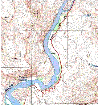
At Tanner Wash, the trail left the river and ascended about 150 feet to by pass a cliff in the PreCambrian Dox Sandstone and returned to river level just south of Espejo Wash. As we were leaving the wash, the trail, which had been adequately marked to this point, lead to a camp at the foot of a cliff and was surrounded by mesquite. To our amazement, the trail abruptly terminated. We backtracked. Couldn't find the trail, mesquite was overhead and thick. We searched and weren't able to find a passage through the mesquite. We defaulted to out mantra, "When in doubt, go high." We resumed our trek back to the camp at the base of the cliff and what had earlier looked like a dead end, was actually the trail. It stayed along the base of the cliff for some distance, circumventing the impenetrable mesquite.
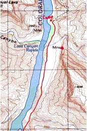
The trail continued at river level, across an unnamed wash that I christened "John's Wash" . It ran low, along a large island located on the map and was easily navigated. The trail ran through sand that was marked on each side by a line of rocks. The going was slowed by walking in dry drift sand. As we proceeded, John pointed out a pile of mine tailings just opposite Lava Canyon Rapids at the base of a cliff. He suggested we check it out later. The river was now flowing grayish brown.
Arriving at Palisades Wash, we set our packs down at the river, got our shirts wet and cooled off. It was 4:30 and we needed to scout a camp site, but first we filled the 5 gallon container with river water to let the silt settle out before filtering it in the morning. Doing a quick survey of our immediate area we discovered no really good camp site. So we took out our walkie-talkies to separately search a wider area. By the way, I would strongly recommend cariryng a pair of these devices on any backpack trip. They're inexpensive, have a range of 2 miles, are relatively light weight and add an element of safely to the hike. I headed North and John went Northeast looking for suitable digs. I found a cool narrow canyon and explored it till I couldn't go any farther without a rope. I returned to my starting point without finding a suitable campsite. John had scouted the area where the Beamer Trail continued and had similar luck. We finally settled on the best spot available that was semi flat and completely open to the night sky. (See picture)
The sky was beginning to cloud up from the south and we wondered aloud if it might rain. We each set up our "tents." John brought his homemade tent consisting of a sheet of black visqueen-type plastic.at the head end, it is held up by a suitable stick. Where the stick poked through the plastic, he'd reinforced it with, drum roll please... Duct Tape! At the foot end, all other edges lay flat on the ground and were held down with rocks, which are not hard to find. I had packed a three season tent in my truck and decided not to carry it into the canyon because the weather was so good. Instead, I brought a tube tent. It's available from Campmor for $4.95. It's an 8 foot diameter cylinder of visqueen-type plastic. You string a rope through it and tie the ends to bushes or trees or whatever. Then you place rocks along the edges, forming a long triangle, open at both ends for good ventilation. It isn't hard to close off one end with a few rocks if rain threatens. My thought was it would work in a pinch.
After dinner and tea, the sky cleared, so I let down the rope that held up my tent and laid my sleeping bag down on top and watched the sky. About 1 AM it started to thunder and lightning and the rain followed, gentle at first. We both got back into our tents. The light show and thunder were intense. Such raw power was dreadfully beautiful and I didn't sleep much. I counted the seconds between lightning flashes and thunder claps. At first it was 10 to 15 seconds. The thunder rolled and peeled across the canyon from the south and echoed off the canyon walls, giving it depth. As the night progressed, it got down to 1 and 2 seconds. The sound occupied most of my sensory input. It reverberated off the canyon walls, filling any voids with more sound. It thrilled me as it scared me. It reminded me of storms I'd seen at sea. Every so often, I'd poked my head out and look for the Desert View Lookout Tower near the Tanner Trail trailhead toward the southwest. It helped me stay grounded throughout the storm.
- Start of Beamer Trail from Tanner Wash heading north toward Palisades Creek
 Beamer
Trail continuing north to Palisades Creek
Beamer
Trail continuing north to Palisades Creek
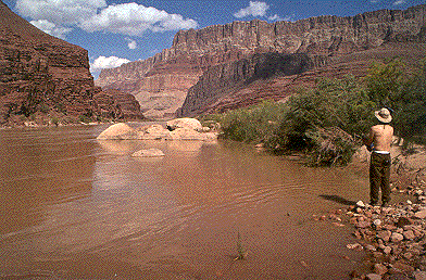
John cooling off at Tanner Wash, just above Tanner Rapids
 Poor
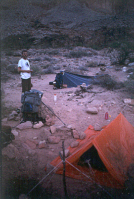
Camp at Palisades Creek after the storm
Poor
Camp at Palisades Creek after the storm
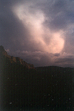 Gathering
storm at sunset
Gathering
storm at sunset

One of Wayne's Time-lapsed Photos at night showing the Earth's rotation against the starry background