|
|
|
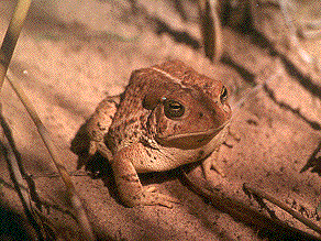
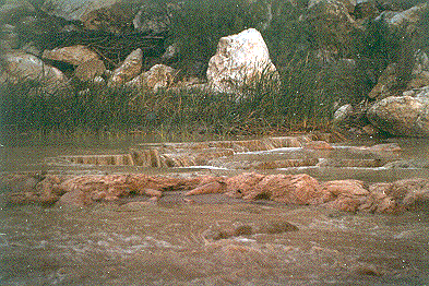
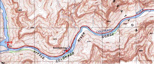
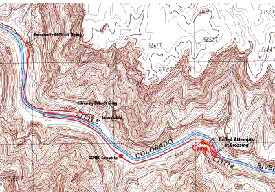
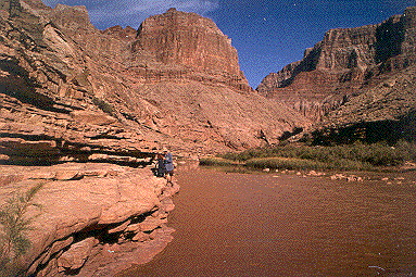
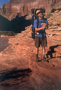
Last night we again filled the plastic container with water to let the silt settle before filtering. Slept well. Granola and coffee for breakfast. It must be said that I like my morning coffee and prefer not to do without it, even in the wilderness. So I brought along my very cool, portable French coffee press. It consists of a standard insulated plastic cup with an added attachment. Through the center of the snap-on lid is a small metal rod. On the lower end is a fine-meshed filter that is the same diameter as the inside of the coffee cup. On the upper end that sticks through the lid is a knob. To make a truly delicious cup of coffee you add coarsely ground coffee directly into your cup. Next you pour in the hot water, slide the filter into the cup and snap on the lid. I let it stand a couple minutes and then depress the knob, forcing the filter to strain the coffee through the hot water to the bottom of the cup. No other method of making coffee does as good a job. John has an identical cup and though he didn't bring it on this trip, he told me he uses it every day when at home. I really enjoyed my coffee while in Grand Canyon but I did leave half of my ground coffee at home in the freezer! Our options for further explorations were somewhat limited. We could continue heading up the Colorado by blazing our own trail, hang out here at the confluence or head up the LCR (Little Colorado River). We were both a little tired of blazing trails, so heading up the Colorado wasn't in the cards. The main river, though less muddy still made fishing impossible and the camping conditions weren't all that good, so we decided to continue on up the LCR. Along the LCR, on the north side, there is a narrow shelf that makes the going pretty easy. This shelf contours along with the river, about 1-3 feet above waterline. As we progressed, we passed several shallow caves, some with interesting cave-like structures. One feature that was really cool were some active "soda straws" exposed under protective shelves made not of your common limestone but salt. Along this Tapeets sandstone in this area of the Canyon, salt deposits are very common and contribute the brackish quality of the water in the LCR. The Native American tribes of the region have sacred salt mines along the Colorado River. We hadn't gone too far up the LCR when we met the same researchers we talked to yesterday. They were carrying buckets, fish traps and other equipment and were camped about a hundred yards up river. In addition to this well fortified camp, they had two additional campsites occupied by other scientists further up river. Along most of the LCR were travertine pools formed by the deposition of minerals from the water. I had seen pictures of them when the aquamarine water was running low and clear but because of the recent downpours upstream, it ran muddy during our days along the river. The walk was easy, and we made good time. We found the researcher's camp and stopped to talk with the men there. They related the same stories as their colleagues. One researcher named Paul suggested we be on the lookout for Dennis who had been coming to the river for many years and knew the trail out along the LCR and the Salt Canyon. He could tell us what we wanted to know about the trail ahead. He had asked us if it was our truck that was parked in the middle of the helicopter landing pad at the trailhead. I told him I didn't know it was a landing pad. I only parked there because it was the only flat spot around. Continuing up river, we met the second group. Dennis told us to cross the river soon, because further up along the north side of the river, the going would get difficult to impassable with tammies, mesquite and acacia. Also he warned us that we'd be coming to the Hopi Sacred Mound, where the Hopis believed their ancestors emerged from the earth that was also on this side of the river. He warned us that it is one of the most sacred of all Hopi sites, and not to walk near it (we didn't). Upon seeing my camera, he said not to even take a picture of it (I didn't). He said to cross the river back to the north side immediately after the Sacred Mound, as the crossing would be relatively easy and the route was again passable back on the north side. But because the going was so easy, we decided to continue on the north side ignoring Dennis's advice. A mistake of major proportions! We hit the tammies. We hit the mesquite. We hit the acacia. We got cut to ribbons. We again tried to follow our mantra,"When in doubt, go high." Well, we went high. We ran into every adverse condition but rattlesnakes. We tried to go up and around the vegetation, but ran into very steep, rocky terrain. Looked for cairns but found none. The going would get easier for a small distance, only to lead us into more acacia. The acacia would thin out, only to lead us to steeper slopes. Ultimately we were forced to descend back into the acacia. After a few hours of minimum headway, we came to an overlook where we could see the Sacred Mound, but the going was impassable. Total and complete frustration. We were about 200 yards from the trail on the east side of the mound and couldn't get to it. We backtracked perhaps half a mile and found a crossing to the south side. The river here was about 50 yards wide. We again took off our shoes and pants and started across. All went well till the last few yards at which the river, ran pretty fast, and much deeper. (We had used our walking sticks to probe the depth of the muddy water). John came up with a good idea. He suggested taking off our sleeping bags, that were fastened low on our packs and heaving it the rest of the way and swimming the last few feet if necessary. If anything got wet, no harm. As I stood in the river, with water up to my crotch, I untied my bag and prepared to heave. Ever try to throw something with a back pack on while standing in waist deep water? Well, I drew back and swung the bag with all my might. I immediately saw it would make it with yards to spare. But no! It hit the top of some tammies and sprang back into the river! Bummer! I was paralyzed. I must have stood watching my sleeping bag slowly begin to sink for a full minute. Fortunately it had lodged in some tammies growing by the bank and wasn't carried downstream. I looked at John in disbelief. I edged as close to the shore as possible and made a jump for it. That wet sleeping bag was plenty motivation and I made the shore easily, grabbing my bag on the way. It had only absorbed a pound or so of water. I guess it had been so compressed in the stuff bag that it didn't take on as much water. John threw his bag and it almost went out of the canyon. He had plenty of motivation after watching my fiasco. We regrouped on shore and continued east finding a trail immediately. After what we'd gone through, it looked like a freeway. We soon met up with the second group of researchers. Louie was the leader. Dewy was his assistant. I was going to ask them where Hughie was but decided not to. We briefly related our trip so far and asked about the trail out of Salt Canyon. Louie said he wasn't sure, but said Randy, the leader of the third group of researchers that were camped at the entrance to Salt Canyon would know. Louie offered to top off our water bottles with fresh, clear, water from their stash and we grateful accepted. He told us where a shallow crossing was to get back to the north side. Before he sent us up stream he asked if that would that be your truck parked in the middle of the helicopter landing pad...?" Again I explained my excuse. It was about 3:00. The going was again, hard. No clear trail. Researcher footprints here and there. We passed a shallow cave with some of their equipment just inside. We pressed on so we could cross the river before dark. We came to the island Louie told us about where a crossing would be possible. He said to watch for their footprints to see where they crossed. We found their footprints. From shore we tested the depth with our hiking sticks. It got deep quickly, too deep. For an hour and a half we searched for a good place to cross. John took off his boots in several promising locations and waded as far as he could. Each attempt failed. The water ran too deep and swift wherever he tried. We figured we could always swim across, but how would we keep our equipment dry? (During our search, we found several brackish springs.that we guessed we could drink in an emergency.) The light was rapidly failing in the canyon so we decided to go back to the cave, pitch camp and attempt to ford tomorrow. It was the only wise decision we made all that day. Dinner of freeze dried something or other and tea. We found the strength to hang our food in the brush. We've paid enough "critter tax." It was a very tough day. We slept out under a clear sky and watched the stars. I slept well. |
|
|
|
|
|
|
|
|
|
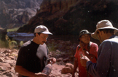
Louie, Dewy, and John |
|
|
|
|
 John
on shelf along LCR
John
on shelf along LCR