![[Company Logo Image]](_borders/citylogo.jpg)
sangermanpr.cjb.net
![]()
![]()
sangermanpr.cjb.net
|
|
|
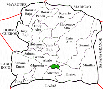
483 Years of History:Before you read this section, it is important that you learn some terms: Municipality (Municipio): Roughly the equivalent to a County. Puerto Rico has 78 Municipalities. Each Municipality is divided in several boroughs (barrios) and each municipality has a city of the same name. Few municipalities have an additional town besides the city. San Germán has the San Germán city (zona urbana, or urban zone) where the administrative offices, city hall and Parrish are located. It also has one small town located in the northeast of the Municipality called Rosario, with it's own Parrish, but no Mayor or local government. At a given time, San German was composed of 24 of the 78 modern municipalities, including Ponce and Mayagüez, from which all seceded, giving San Germán the name of City founder of Towns. Barrio: Boroughs. Postal Abreviation: Bo. - Each Municipality is sub-divided in Boroughs. Boroughs have no other purpose than identifying zones in a Municipality. San Germán have 18 of these, shown in the map below:
San Germán and it's boroughs, courtesy of "1898, La Villa de San Germán"
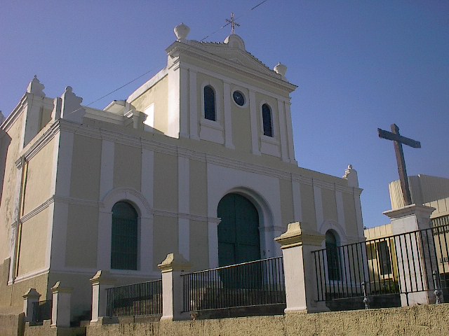
For over four centuries has our town been present in the Borinquen landscape. It has changed it's location several times, giving it the name of "The Pilgrim City". Currently only 54 square miles in territory, this Municipality was once the size of all of western Puerto Rico, covering from Arecibo to Ponce. Now reduced to a small city in a small island, this city is home to 38,000 inhabitants. For the towns nearby, plus a few tourists, our city is more than just an urban center. It's the second oldest city under U.S. flag, and the home of western Puerto Rican history. Our history starts somewhere between 1506 and 1512. If it starts in 1506, we are the oldest city in Puerto Rico. If it starts in 1512, we are the second oldest (San Juan's history starts around 1510). The theory of 1506 is supported by the historian Aurelio Tió, and it's still debated. The Theory of 1506 states that San Germán started as a town named Higüey, on the banks of the Añasco River. This small ville was destroyed by Chief Guarionex of the Taíno Indians, and it was rebuilt in 1511. The Theory of 1512 states that San Germán has it's origins the Bay of Guánica, founded in this year by Cristóbal de Sotomayor and known as Villa Tabora. This ville was moved to the Añasco area due to a Mosquito Plague in the Bay. The old San Germán ville was continuously attacked by Taíno Indians, by enemies of Spain (France and Great Britain), and it's distance from San Juan made it difficult to protect. But our people never backed up, moving the town's location to more protected places each time they were attacked. It was then that the town was given the name of "The Pilgrim City" (La Villa Andariega). The settlers finally arrived to a small valley between the Saint Martha Hills (Lomas de Santa Marta) and the Central Range (Cordillera Central). This valley is now known as the Guanajibo River Valley. It was here where the city finally started it's growth and became the Capital City of Western Puerto Rico.
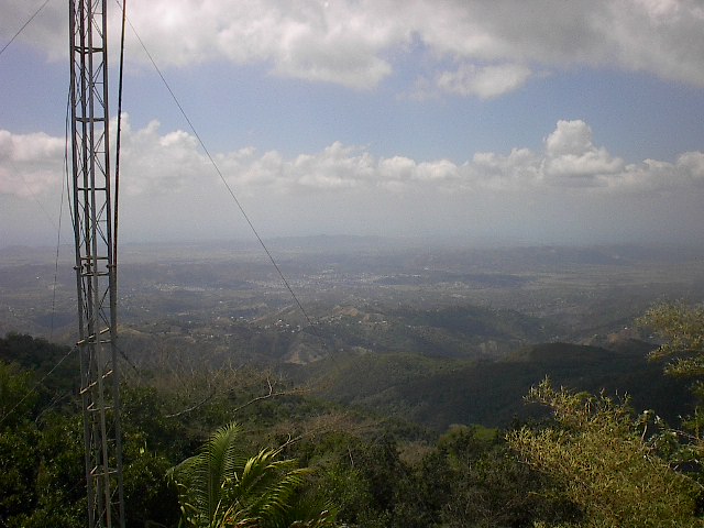
San Germán City, as seen from the highest peak in Western Puerto Rico. You can see how the city has grown nestled between the Saint Martha Hills (behind the city) and the Central Range (from where this picture was taken). San Germán is located in the Guanajibo Valley between both mountain ranges. At the horizon you can see the Caribbean Sea, about 8-10 miles from San Germán. Finally, in 1573 the town was incorporated, and in 1877 given the status of City by a Royal decree from the King of Spain. By this time, there were only two Municipalities in the island; San Juan, which covered from (present) Arecibo to Utuado, and from (present) Orocovis to Guayama; and San Germán, which covered the rest of the island. Centuries went by, and the city was completely forgotten by San Juan and Spain. It's settlers would survive with agriculture, and would bring imported goods through bargains with Caribbean pirates. In the 19th century, San Germán experienced much needed growth in the Fine Arts, Culture and Commerce. It was considered the biggest city in the western part of the island. At the same time, smaller towns were created along the territory. The distance between these towns and the mother city of San Germán was too much for these towns to survive, and an inevitable wave of secessions started sweeping the municipality. This wave of secessions affected the city's treasury, watching as taxpayers money started filling the treasuries of newly created Municipalities. The last towns to become Municipalities from the San Germán territory were Guánica and Lajas, in the last years of the 19th century. By the 1900's, San Germán was reduced to it's current 54 square miles, having only one town left in it's territory; Rosario. Rosario is still part of our Municipality, and it's people proud Sangermeños. Although there is still secession dreams in the town, the truth is that the enormous amount of Municipalities in an island only 100 x 35 miles in territory makes it almost impossible to create new Municipalities. Still, San Germán stands proud as the "City founder of Towns", mother-city of the 24 cities and towns listed below: Ponce, Mayagüez, Aguadilla, Arecibo, Coamo, Cabo Rojo, Hormigueros, San Sebastián, Añasco, Aguada, Rincón, Hatillo, Isabela, Maricao, Lajas, Guánica, Peñuelas, Guayanilla, Moca, Lares, Las Marías, Sabana Grande.
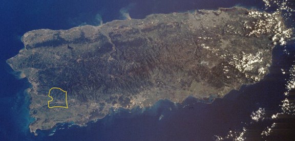
This picture taken from space, shows in yellow outline the limits of the municipality of San Germán in the island of Puerto Rico. The gray patch in the lower center of the municipality shows tle location of San Germán city. We are located approx 20 minutes drive from Mayaguez (the gray patch in the western coast); 40 minutes from Ponce (gray patch in the southern coast); and 2 hours from San Juan (huge gray patch in the northeastern coast). San Juan, although considered small by many outsiders, is actually a metropolitan area with a population larger than Baltimore or Phoenix, within a small land area. You should also be able to see at least 70 small gray patches. Every gray patch stands for a different town or city. Photo courtesy of Dr. Carlos Avilés and "1898, La Villa de San Germán". In 1897, Puerto Rico was given the Letter of Autonomy, where Spain granted independence to the Island of Puerto Rico, event celebrated in San Germán with parades and protocol events such as the planting of the Ceiba of Liberty, in Liberty Hill. Three sangermeños were appointed to the first congress of the Country of Puerto Rico; Francisco Mariano Quiñones, Manuel F. Rossy and José Servero Quiñones. While Spain was granting Puerto Rico it's independence, the United States declared war. Spain would lose this war, and Puerto Rico would become a territory of the United States. The U.S. Army entered western Puerto Rico meeting no resistance from locals, who despised Spain rule. The marching of the U.S. Army in San Germán streets would mark a new era in our town, an era we are still living today. The United States have maintained a far better relationship with Puerto Rico compared to Spain. The United States created under the Interstate program our first highway, PR-2 which crosses San Germán and connects it with Ponce and Mayagüez; It also gave our citizens U.S. Citizenship, which allowed hundreds of sangermeños to join the Armed Forces. It brought the first private university of Puerto Rico to San Germán (Polithecnic Institute of Puerto Rico, now Inter-American University), basketball, potable water, electricity and welfare to our poor population. One of our local prides is the Atléticos de San Germán Basketball Team (www.atleticos.org) , first professional basketball team in Puerto Rico, and holder of the championship titles in 1932, 1938, 1939, 1941, 1942, 1943, 1947, 1948, 1949, 1950, 1985, 1991, 1994 and 1997. We are also known to be the cradle of basketball in Puerto Rico. Today, San Germán is still a small city with little over 38,000 people living in the 18 barrios and urban zone. Although there is much debate over if Puerto Rico should become the 51st state, an independent country, or maintain the Status Quo of Commonwealth, San Germán still lives quietly nestled between the southwestern mountains of this beautiful island called Puerto Rico, silent witness of 4 centuries of history.
References:This page would like to acknowledge .
|
|
Send mail to [email protected] with questions or comments about this web site.Unless otherwise stated, information in this page comes from the Municipality of San Germán, Tourism Department; Owner's Interpretation; Some information and photos property of the website "1898, La Villa de San Germán" and it's owners, from which I am eternally grateful for being my inspiration; Pictures of San Germán in this website, unless otherwise stated are property of Michael González. The author of the pictures retains it's rights. Pictures can be used without permission for educational purposes, or non-lucrative purposes only. Please link the pictures to this website and give proper credit if using. Pictures will NOT be used for lucrative purposes.
|