|
|
|
|
|
|
|
|
|
|
|
|
||||
|
|
||||||
|
|
||
|
AYDINCIK The town where 8760people live in,lies along the shore and because of warm climate generally agriculture ( cucumber,tomatoes and eggplant in green-house) and fishing take an important role for a living. The Districh without big buildings has all the particularities of a Mediterranean village.What a pity that such a beautiful region is not known by tourists. Aydıncık awaits adequate investments. Aydıncık, a port of the province of İçel, lies on the Mersin - Antalya D-400 highway. The rown is 175 km from Mersin and 325 km from Antalya.It is 75 km west of Silifke and 52 km east of Anamur,32 km south of Gülnar. Mediterranean climate is predominant in the region.In summer the mean temperature is 30°C. The hottest months are July and August. During these months the temperature may rise to 35°C. The sea will be about 29°C. Humidity in summer is 75%. In winter the mean temperature is 12°C, the sea about 13°C. The coldest months are January and February. During these months are temperature can drop to I degree but frost is rare. Winter humidity is about 60%. Aydıncık is in a bay enclosed by the Taurus Mountains. In the foothills of Tülüce peak the İncekum and Büyükalan beaches where the the sea deepens gently, wellcome people to enjoy the area. Off Büyükalan lie to islands: the first is << leek island >>so named by Piri Reis. This is Büyükada, where grow narcissus and where ruins existe. The second is Küçükada . It is Küçükada where the rare Audouin's gulls (larus audouinii) can be found. In a harbour the beautiful blue sea makes a U turn. In the south of this inlet there is a peninsular about 25 metres in height and 200 metres in lenth. This peninsular has been artificially lengthened by 200 m to form the southern side of the fishing port. In the valley of Soğuksu , The Mediterrean becomes shallow to say farewell to the people of Aydıncık. Since the summer of 1998 water has been taken from Soğuksu Stream to Cyprus. Aydıncık's old name Gilindire is derived from Kelenderis the name mountainous Cilesia gave to the harbour town. With no historic connection at all the name Aydıncık was given in 1965 .The name Gilindire which takes us deep into history is no use inofficial and like a sunken boat,lies buried in the blue waters of Mediteranean. According to mythology Kelenderis was founded by Phoenician Sandokos coming from Syria in the year 2000 BC. It is believed that lonians developed the town as a colony. In Kelenderis which was an important Cilesian harbour lived lonian,Hittite,Assyrian,Phoenician,Rouman,Byzantine,Emevi Arab,Armenian,Selcuk and Ottoman periods. Towards the middle of the fifth century coins started to be minted. The name Kelenderis was shortened and written in Greek on coins. Of these coins one made in the second half of the 5 th century BC was found at Acemhöyük near Aksaray. At Bereket village near Aydıncık 35 staters found was dated 4 th century BC. At the time of the Ptolemies it came under the rule of Egypt. In 1979 during foundation excavations in the ancient city area 17 gold tetradrahmi were found. On the money were Ptolemy II Arsenoe II portraits. In the 7 th century when The Emevi Arabs were taking possession of Cyprus they occupied Gilindire Castle. With the help of the Armenians and Byzantines the castle again returned to the Byzantines. Towards the end of the 11 th century Byzantine sovereignty was removed and a small Armenian kingdom came into power. In the period of Alaeddin Keykubat, Ertokus Bey captured Anamur and Gilindire castles. This was in 1228. In 1461 the region joined the Ottoman administration. In 1867 the İçel sub-province joined Karaman province. At this time İçel'ssub-provincial districts were Anamur,Mut,Silifke and Gülnar whose centre was Kilindria. At the beginning of nineteen hundreds while Gilindire was an Adana provincial district,Gülnar was a market village for Nomads. On the 9 th March 1912 a Greek ship flying an English flag fired guns at Gilindire and then madea landing at Büyükalan. The peopleof Gilindire drove the enemy from the land . To get away from possible attacks from the sea the district administration was moved to Gülnar. In May 1916 Gülnar became a district and Gilindire lost attribute. In 1972 it was made a town and on 19.06.1987 Aydıncık (Gilindire) once again became a district.
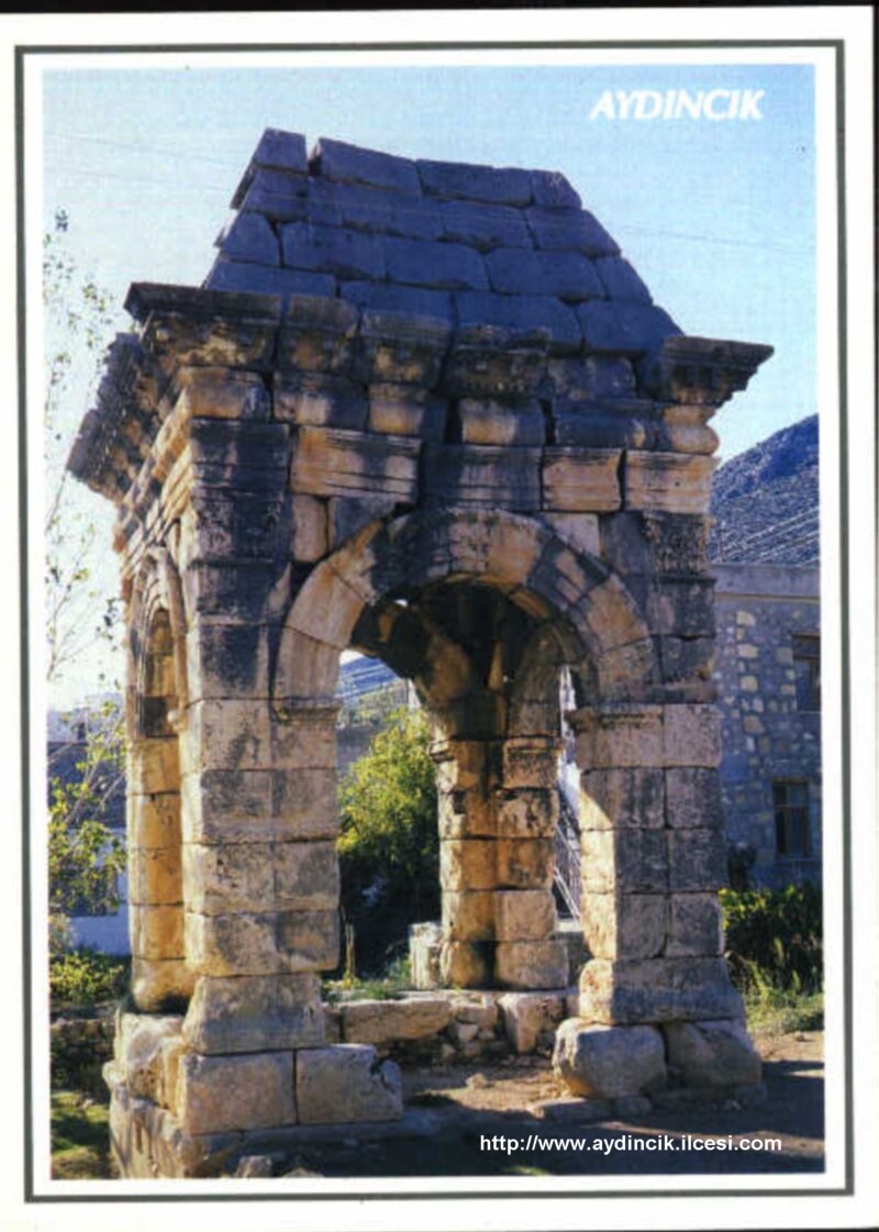
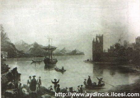
Because it has four great feet,the people's namefor this tomb is << four feet >> and it comprises three divisions: 1-burial room. 2- on four big supporting columns ( called elephant feet ) another room with four arched sides. 3- a pyramid shaped roof. This eight metres high historical monument could be of the second century A.O. Because the burial chamber has not yet been opened and though it must be a construction for an important person whether this person is buried within and it is a true grave or whether it is just a monumental construction is not known. Captain Beaufort's Chilindreh ( old Kelenderis ) harbour map shows someone's memorial but this person was not buried there and it is an empty grave. The oldest drawing we have of this grave is an 1851 gravure published by the Museum of Antiquities.
Kelenderis in its first period was a port town for mountain Cilesia. The Piri Reis map shows a castle on the point of bay. The map of Kelenderis harbour drawn by Captain Beaufort in 1818 shows an eight-sided tower and ruined castle on the peninsular. On the north-west side of the harbour baths are shown,and to the north garves. As well there is shown on the map a tomb made in name of someone who is not buried there. The first drawing of the harbour to reach us which was of interest was a gravure by W.H.Barlett in the 1838 publication of J.Carne. A ground mosaic found in 1992 which can be dated about the fifth century describes the Cilesian harbour.
These were constructed either in the firs half of the 5 th cuntury or in the 4 th century. The height of construction is today about 8,5 m and it occupies about 600 square metres. In 1962 while the old narrow Mersin-Antalya road was being widwnwd, part of the baths was demolished.
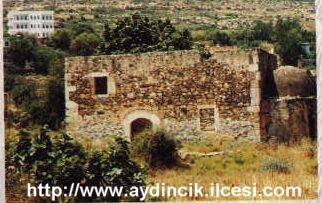
It is that this was built in the 19 th century on land close to the port. Right beside it a ruin was filled in and used as the church graveyard. According to Prof.Dr.L.Zaloğlu this place was cleared and a theatre came to light.
Concerning Aydıncık's past the best knowledge and the most worth while can be found in the excavation area of the inn ruin. The ground mosaics were found here.
In the east and west of the town were graves. During their excavation Phoenician and Persian amphora were found. In the centre of town beside the Mersin-Antalya highway vaulted graves still exist.
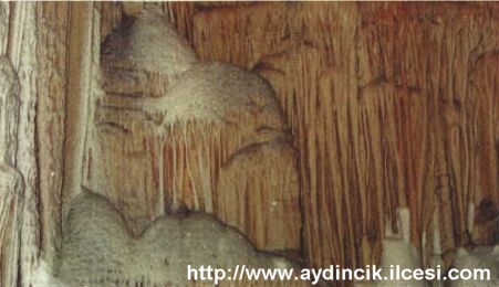
A natural wonder to the east of Aydıncık ! As yet there is no road, you can reach the bay in about an hour. On the right arm of the mountain a half moon shaped cavity which is mouth covered by bushes can be reached after you have wolked about 200 m. A cool breath of air will meet you . The first part of the cave is descended with difficulty. Then you find yourself surrounded by a bombed ruined city. Magnificent stalagmites and stalactites greet you.
Having gone ashore from your boat to the east of Aydıncık and having wolked 50 m towards the rocks, you stand before a cavity 80 cm high and 60 cm wide. Inside the air is warm and humid. At about 7 metres high the visitor meets flying bats. Going further down the he meets a forest of stalactites and stalagmites. A stairway had been made years ago from stalagtites and stalagmites . The pieces are so welded together that it is not possible to separate them. After an hour's walk you will find a pool about 100 metres long ,20 metres wide and in tree to five places 30 metres deep. At present what can only be reached by sea and perhaps waht might be considered the eight wonder of the world this cave about 15.000 m² awaits nature lovers.
Situated at Soğuksu to the west of Aydıncık ,this cave is of interest fot its lacties and stalagmites . It can be reached by land or sea.
According to K.Gökhan Türe the mouth of this cave is 7 metres under Mediterranean where salt and fresh water mix, there are about 2 metres of cloudy water. From there on the water is completely sweet and clear. At the end of a hundred metre tunnel fresh water comes though crachs in the wall. |
||
|
http://www.aydincik.ilcesi.com © 2003 Bu sitede yer alan yazı ve resimlerin her hakkı www.aydincik.ilcesi.com 'a aittir. Ticari veya özel alanlarda izinsiz kullanılamaz.
|
||

