Annadel State Park
Distance: 5.3 miles round-trip/3 hours Level: Easy
Elevation Change: 500 feet Rating: * * *
Directions: From U.S. 101 in Santa Rosa, take the Fairgrounds/Highway 12 exit. Highway 12 becomes Farmers Lane. Turn right on Montgomery Drive and follow it for 2.7 miles (veering to the right), then turn right on Channel Drive. Follow Channel Drive into the park, stop at the ranger station for information and maps, then drive to the end of the road and park in the lot (it's a total of 2.2 miles on Channel Drive).
Annadel State Park is a horsy kind of place. If you count the horse trailers in the parking lot, the hoof prints all over the place, and the horse "evidence" along the trail, you might think more horses visit here than people.
Then again, Annadel is also a mountain biker's kind of place. Most of the trails at Annadel are open to bikes (not just the usual wide fire roads). The bikers and equestrians share the trails with great equanimity, and trail conflicts are rare to nonexistent.
Considering all this, it�s surprising that Annadel is also a hikers kind of place, but it is. Annadel's 5,000 acres are filled with woodlands, meadows, seasonal creeks, wildflowers, and even a 26-acre lake, all of which are worth seeing on foot. One particularly pleasant trail, Steve's S, is designated for hikers only.
With dozens of trail junctions in this large park, a good map is essential. Pick one up at the ranger station when you drive in. And if you think you know your way around becauseyou've visited Annadel in the past, know that many park trails were rerouted in 2001-2002 in a major restorative effort designed to protect fragile meadows and marsh areas.
Start at the Warren Richardson trailhead at the end of Channel Drive. On one trip, we got out of our car and heard a loud ruckus. Two dozen male turkeys, divided into two groups, were battling over a flock of hens alongside the parking lot. It was like West Side Story with feathers.
Take the hikers-only trail from the far end of the parking lot or the wide fire road from its center; both meet up in a few hundred feet. At that junction, head uphill on narrow Steve's S Trail, leaving the road to the cyclists and horses. The trail makes a good climb over a mile with just enough of a pitch to get your heart rate up. It weaves through a dense and shady Douglas fir forest, interspersed with a few redwoods and bay laurels for variety. The woodland floor is lined with sword ferns. In early spring, look for rare redwood orchids among them.
After gaining a ridge, Steve's S Trail meets back up with Warren Richardson Trail heading right. Go right (south) and then right again on North Burma Trail to regain Steve's S Trail, heading left. You'll walk through an open meadow peppered with bright yellow mule's ears in the spring and early summer. Bordering the meadow are a mixed variety of oaks�canyon, blue, and valley. Continue on Steve's S Trail for a half mile to the northern edge of Lake Ilsanjo. You'll head back into the forest
again, but this time into an oak and madrone woodland. The black oaks
turn bright colors in the fall.
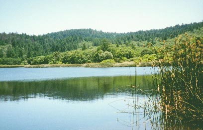
Go left to circle the lake clockwise. You'll gain the best views of blue water, tules, and paddling water birds as you walk across Lake Ilsanjo's earthen dam. The natural-looking reservoir is a refreshing contrast to the manzanita and chaparral surrounding it. If you're wondering about the origin of the lake's name, "Ilsanjo" is a combination of lisa and Joe, the names of the land's former owners, who built the lake's dam.
Ilsanjo's tule-lined shores are popular with bikers, hikers, picnickers, swimmers, and anglers. More than a few visitors make this a combination hiking/fishing trip, stalking along Ilsanjo's shoreline to cast for good-size largemouth bass and plentiful bluegill.
At the far side of the dam, you'll wind up on Rough Go Trail. Follow it past the lake for .5 mile, then bear right on Live Oak Trail. Go north and connect with the North Burma Trail; after 1.8 miles, turn right onto Channel Trail, which takes you .8 mile back to the parking lot.
Options
To add on a few more miles to this hike, take Spring Creek Trail from the west end of Lake Ilsanjo's dam. The trail follows Spring Creek for 1.3 miles to Canyon Trail, then connects to Rough Go Trail and eventually rejoins the loop described above. This option will add just under three miles to your loop. Or, if you've visited Lake Ilsanjo before, you might want to try one of Annadel's other special trails. Bring your binoculars and your bird identification book for a hike to Ledson Marsh, accessed via South Burma or Two Quarry Trails off the wide Warren Richardson Trail. Once you're near the marsh, you can loop around it on Marsh and Ridge Trails. For a bit of history, don't miss the half-mile Rhyolite Trail spur off Marsh Trail, which leads to the site of the Gordenker Quarry.
Trip Notes
A $2 day-use fee is charged per vehicle. Dogs are not allowed. Bikes are allowed on all trails except Steve's S and Rhyolite Trails. Park maps are available at the ranger station. For more information, contact Annadel State -Park, 6201 Channel Drive, Santa Rosa, CA 95409, 707/539-3911 or 707/938-1519, website: www.parks.sonoma.net.