Sugarloaf Ridge State Park
Distance: 6.8 miles round-trip/4 hours Level: Moderate
Elevation Change: 1,500 feet
Directions: From U.S. 101 in Santa Rosa, take the Fairgrounds/Highway 12 exit. Highway 12 becomes Farmers Lane as it heads through downtown Santa Rosa. Continue on Highway 12 for 11 miles to Adobe Canyon Road and turn left. (Or, from Highway 12 in Sonoma, drive 11 miles north to Adobe Canyon Road, then turn right.) Drive 3.5 miles to the park entrance kiosk. Park in the lot about 100 yards past the kiosk, on the left. Take the trail signed as "Lower Bald Mountain Trail."
While the grassy summit of Bald Mountain at 2,729 feet is the crowning glory of this loop trip in Sugarloaf Ridge State Park, each leg of the route bestows its own rewards. Take the most direct path to the summit, then loop back downhill on a series of trails for a roundabout tour of the park's varied terrain.
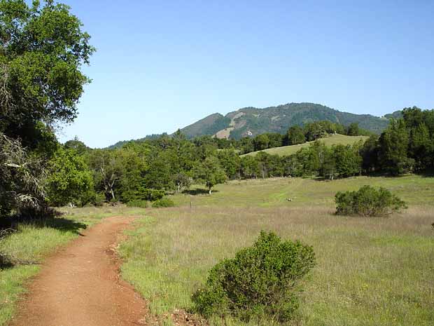
Start your trip on Lower Bald Mountain Trail from the parking lot just past the entrance kiosk. At its start, the well-graded path climbs a grassy slope. Deer frequently graze in the open meadow, which is covered with wildflowers in the spring, especially Douglas iris, California poppies, brodiaea, and blue-eyed grass.
Tunneling through a hardwood forest, the path meets up with Bald Mountain Trail, a paved service road. The pavement makes less pleasant hiking, but this 1.4-mile stretch ascends quickly through slopes covered with ceanothus, manzanita, chemise, and toyon. The blooming, scented chaparral will take your attention away from the asphalt.
At 2.3 miles from the start, reach the pavement's end at a saddle and trail junction. The left fork leads to microwave tower-covered Red Mountain at 2,548 feet. You'll go right for Bald Mountain, now following a dirt fire road. The final .5 mile ascends grassy slopes with occasional outcrops of green serpentine. The dirt road curves around the north side of the peak to a junction with Gray Pine Trail. Take the short spur on the right to reach the 2,729 foot summit of Bald Mountain. It's bald indeed; not a single tree obstructs the sweeping panoramic view.
Two signs at the top identify all the neighboring landmarks, including Mount St. Helena, Mount Diablo, Bodega Bay, Mount Wittenberg in Point Reyes, Snow Mountain, Mount Tamalpais, the Golden Gate Bridge towers, Angel Island, and the Bay Bridge. Most impressive is a rarely seen glimpse of the Sierra Nevada, 130 miles away. A quote from author Robert Louis Stevenson sums up the scene: "There are days in a life when thus to climb out of the lowlands seems like scaling heaven."
From Bald Mountain's summit, take wide Gray Pine Trail east, descending along a ridge. In .8 mile, turn right on single-track Red Mountain Trail. The trail dips and climbs through chaparral for nearly a mile. Watch for the left turnoff for Headwaters Trail; take it and enjoy a nice downhill stretch along the headwaters of Sonoma Creek. After half a mile, bear right on Vista Trail. The path skirts lovely meadows with fine views of the Sonoma Creek canyon and Sugar-loaf Ridge, then ends at paved Bald Mountain Trail. Follow the pavement downhill for only .25 mile to the left turnoff for Lower Bald Mountain Trail. The final mile is an easy descent back to your car.
Options
An alternate and slightly shorter route downhill from Bald Mountain's summit stays on Gray Pine Trail for a rollicking descent along the ridge-line. Gray Pine Trail rolls along and then descends for 2.5 miles to Meadow Trail, where you turn right for a mile-long stretch along Sonoma Creek to the site of the park's Ferguson Observatory (707/833-6979, web-site: www.rfo.org), which is open to the public for stargazing on certain weekends throughout the year. Beyond it lies the last quarter mile of Lower Bald Mountain Trail, which leads back to your car.
If you'd rather extend your trip instead of shortening it, take Gray Pine Trail east for 1.1 mile from Bald Mountain's summit to Brushy Peaks Trail. This pathway leads southeast for another 1.1 mile to the summit ofBrushy Peaks, elevation 2,243 feet. The trail continues past the peaks for two miles and then eventually joins with Hillside, Meadow, and Gray Pine Trails. Meadow Trail is the shortest route back to your car. The combined Bald Mountain and Brushy Peaks loop makes an eight-mile day.
Trip Notes
A $4 day-use fee is charged per vehicle. Dogs are not allowed. Bikes are allowed only on fire roads. A trail map is available at the entrance kiosk for $1. For more information, contact Sugarloaf Ridge State Park, 2605 Adobe Canyon Road, Kenwood, CA 95452-9004, 707/833-5712 or 707/938-1519, website: www.parks.sonoma.net