Sugarloaf Ridge State Park and Hood Mountain Regional Park
Distance: 7.0 miles round-trip/4 hours Level: Strenuous
Elevation Change: 1,900 feet Rating: * * * *
Directions: From U.S. 101 in Santa Rosa, take the Fairgrounds/Highway 12 exit. Highway 12 becomes.Farmers Lane as it heads through downtown Santa Rosa. Continue on Highway 12 for 11 miles to Adobe Canyon Road and turn left. (Or, from Highway 12 in Sonoma, drive 11 miles north to Adobe Canyon Road, then turn right.) Drive 2.2 miles to the small parking area on the left at a bridge over Sonoma Creek (it's 1.3 miles before the entrance kiosk for Sugarloaf Ridge State Park).
Special note: A storm in late 2002 caused a slide that destroyed the first section of Goodspeed Trail. The trail is scheduled for repair, but until that occurs, hikers can access the trail by following a dirt road that begins .5 mile below the trailhead parking lot, at an old, closed restaurant.
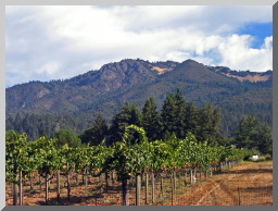
Mount Hood is a 2,730-foot peak in Sonoma County located just outside the border of Sugarloaf Ridge State Park. Despite its respectable size, Mount Hood has one drawback�its summit view is a big disappointment. Manzanita and pine trees cover its wide, rounded top. You can't see a darn thing from up there.
Fortunately, Mount Hood has Gunsight Rock, located .25 mile and 300 feet below its summit. From lofty Gunsight Rock, just about everything in Sonoma County is in view, plus the big mountains of Napa and Marin. Not only that, but Gunsight Rock's boulder-lined outcrop is perched so dramatically on the steep slope of Mount Hood that its precarious dropoff makes the vista even more impressive.
Getting to Gunsight Rock is just as enjoyable as being there. The route to the rock on Goodspeed Trail is a study in diversity. It passes by redwoods, bay laurel, manzanita, oaks, grasslands, wildflowers, serpentine, and wildlife. You get a sampling of much of the Bay Area's natural history on the seven-mile round-trip. For the best experience, pick a clear, cool day, preferably in spring when the wildflowers are in bloom.
Goodspeed Trail's trailhead and first two miles are located in Sugarloaf Ridge State Park. The trail's final 1.5 miles are located in Hood Mountain Regional Park. From the trailhead at the bridge on Adobe Canyon Road, you enter a shady redwood forest and take a mellow stroll through the big trees. Two footbridges carry you across Sonoma Creek and Bear Creek. The first quarter mile of redwood forest is so captivating that you may be tempted not to press onward, but do so and you quickly exit the shady stream canyon and enter a drier, rockier terrain. The trail begins its moderate but steady ascent on sunny slopes. Blue and white Douglas iris line the path in April.
At nearly one mile out, you'll cross a dirt road, then pick up the single-track trail on the far side. The trail drops down to a stream crossing that is dry in summer but a wide, coursing flow in winter and spring. Huge boulders line the stream.
Goodspeed Trail climbs out of the canyon, then continues through an alternating progression of sunshine and shade, grasslands and forest. The exposed slopes of Mount Hood are dotted with serpentine and wildflowers, including red paintbrush, California poppies, brodiaea, blue-eyed grass, and red thistles. The forested slopes are covered by a mix of bay laurel, oak, manzanita, and pine, plus woodland flowers like hound's tongue and shooting stars.
The trail gets progressively steeper as you go. Two conical-shaped peaks come into view at two miles. One looks very green and grassy, the other is covered with chaparral and woodland, but neither of these lesser summits is Mount Hood. Goodspeed Trail ascends along the southwest shoulder of the unnamed grassy summit, elevation 2,350, then makes a series of short, steep switchbacks to rise above it. Look for plentiful poppies and lupine in these grasslands in springtime.
You're given a brief rest at a small saddle, then�surprise�the trail drops back downhill on the northeast side of the forested summit. But not for long; it soon climbs again, and fortunately this final ascent is shaded. You come out to a broad saddle between the two small summits and Mount Hood, and very shortly thereafter is the left turnoff for Gun-sight Rock. Turn left and walk 200 yards to your destination.
A cluster of boulders with a wide notch in the middle, aptly named Gunsight Rock, presents sweeping views to the south, west, and north. Mount St. Helena in Napa and Mount Tamalpais in Marin are easy landmarks. The whole of Sonoma Valley can be seen in one glance. The city of Santa Rosa lies to the west. The dropoffs are extreme from this rocky promontory, so exercise caution.
If you choose to hike the final .25 mile to the summit of Mount Hood, just follow the trail uphill. Its grade steepens and you enter a dry, brittle' forest of manzanita and knobcone pines. The summit consists of a wide dirt clearing, possibly a turnaround for fire engines, encircled by tall chaparral. A visit to this uninspiring spot will probably inspire you to head back down to Gunsight Rock.
Options
Hikers looking for an easy hike in the neighborhood of Goodspeed Trail should drive uphill on Adobe Canyon Road to the main entrance to Sugarloaf Ridge State Park. A few yards west of the entrance kiosk is the trailhead for Canyon Trail, which descends a short half mile to a fetching waterfall on Sonoma Creek. The cataract makes a fine destination by itself, or can serve as a cool, refreshing finale to the Gunsight Rock hike. Note that this waterfall runs year-round but is best seen in the spring months.
Trip Notes
A $4 day-use fee is charged per vehicle. Dogs and bikes are not allowed. A trail map is available at the entrance kiosk for $1. For more information, contact Sugarloaf Ridge State Park, 2605 Adobe Canyon Road Kenwood' CA 95452-9004, 707/833-5712 or 707/938-1519, website: www.parks. sonoma.net