Bothe-Napa Valley State
Distance: 4.6 miles round-trip/3 hours
Level: Moderate
Elevation Change: 850 feet Rating: * * *
Directions: From Highway 29/128 in St. Helena, drive north on Highway 29/128 for five miles to the entrance to Bothe-Napa Valley State Park on the left side of the highway. (It's 3.5 miles south of Calistoga.) Turn left and drive .25 mile to the entrance kiosk, then continue past the visitors center to the horse trailer parking lot on the right. The trail begins on the right side of the horse trailer parking lot
Even the most devoted and enthusiastic Napa Valley wine tasters eventually tire of their task. If it's a hot summer day, perhaps they start to daydream of a shady redwood forest where they could walk for a while or sit by a stream. Such musing might seem preposterous: Where in the midst of the sunbaked vineyards could a redwood tree possibly grow?
At Bothe-Napa Valley State Park, that's where. Ritchey Canyon and Redwood Trails take you through a delightful stand of them, one of the most eastern groves of coastal redwoods in California. Paired with a visit to the summit of Coyote Peak, this loop trip will leave you even more intoxicated with Napa Valley's wine country.
Joining the redwoods are plenty of Douglas firs, buckeyes, and big-leaf maples, plus ferns galore. Look carefully among the branches of the trees: Five different kinds of woodpeckers dwell within the park's borders. We spotted the largest of these, the pileated woodpecker, on a tree right by the picnic area. He was working his way up and down a big Douglas fir like a telephone lineman on triple overtime.
Start your hike by heading up Ritchey Canyon Trail from the horse trailer parking lot. (You can also start by the small bridge near the visitor center, or access the trail from the park campground if you are camping there.) The first half mile is somewhat noisy due to the proximity of the highway and campground, but soon you leave those distractions behind. Ferns, wild grape, and spice bush line the path. Second-growth redwoods are mixed in with Douglas firs. Black oaks and big-leaf maples form a canopy over the trail as well as Ritchey Creek, which runs dependably year-round. (The oaks and maples wear bright yellow coats in autumn.) Keep the creek on your right; the trail narrows and meets up with Redwood Trail, which you then follow. Ritchey Canyon Trail crosses to the north side of the stream.
Three-quarters of a mile from the start, reach a junction with Coyote Peak Trail and bear left. The trail doles out a fair climb but remains shaded most of the way. Soon you leave the conifers and enter drier slopes and a bay and live oak forest. In short order the oaks give way to low-growing chaparral and scattered rock outcrops. Wide views open up on your right of conifer-covered Ritchey Canyon below.
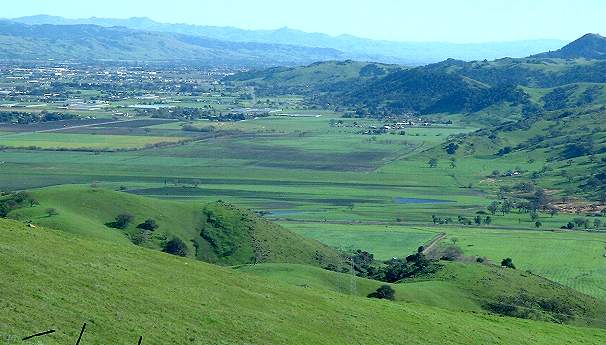
Near the top of the climb you reach a junction; the right fork will be your return. Bear left and make a short but steep ascent to a knoll just below Coyote Peak's summit. You're rewarded with a pastoral view of the vineyards and valley far below�the best view of the day. The summit is a short distance farther, but its vista is somewhat obstructed by trees. Peering through the branches, you can make out Mount St. Helena to the northwest.
Return to the junction with the western leg of Coyote Peak Trail and follow it steeply down the opposite side of the mountain. You'll soon leave toyon, chemise, and ceanothus in favor of shady redwoods. At a junction with South Fork Trail, turn right. Follow a concrete apron across Ritchey Creek, then turn right on Redwood Trail and cross the creek again. The next half mile on Redwood Trail is the loveliest of the trip, featuring the densest redwoods and ferns.
If Ritchey Creek isn't running too full and wide, you can cross it at an obvious (but unbridged) spur, then follow Ritchey Canyon Trail for part of your return. On the opposite bank of Ritchey Creek, Ritchey Canyon Trail passes the old Hitchcock home site, where Lillie Hitchcock Coit and her parents spent their summers in the 1870s. Lillie Coit is best known for lending her name and money to Coit Tower on Telegraph Hill in San Francisco.
Spring is the best season to hike at Bothe-Napa. In April and May, the buckeyes are in fragrant bloom and the creek is running strong. Wildflowers, including Solomon's seal and redwood orchids, bloom in the cool shade in February and March. Park volunteers manage a small Native American plant garden near the visitor center, where you can learn about the local native flora and how it was used by the people who once lived here.
Options
Another trail to try at Bothe-Napa Valley State Park is the History Trail, which leads from the picnic area beyond the group campground. This trail runs 1.2 miles to neighboring Bale Grist Mill State Park, passing a pioneer cemetery along the way. At the trail's end, you have an up-close look at the 36-foot waterwheel, still in operating condition, which ran Edward Bale's flour mill in the 1840s and 1850s. Perennially flowing Mill Creek powered the wheel.
Trip Notes
A $2 day-use fee is charged per vehicle. Dogs and bikes are not allowed. Trail maps are available at the entrance kiosk or visitor center for $1. For more information, contact Bothe-Napa Valley State Park, 3801 St. Helena Highway North, Calistoga, CA 94515, 707/942-4575, website: www.napanet.net/~bothe.