Sonoma Coast State Beach
Distance: 2.0 miles round-trip/1 hour Level: Easy
Elevation Change: 400 feet Rating: * * * *
Directions: From Highway 1 in Bodega Bay, turn west on East Shore Road. (The turnoff is signed for Bodega Head.) Drive .5 mile, then turn right on West Shore Road. Drive 3.5 miles to Bodega Head; take the right fork in the road and head to the west parking lot.
Say "Bodega Bay" and most people's thoughts turn to Alfred Hitchcock movies. And birds. Better they should think of hiking instead, and wildflowers, whale watching, and coastal vistas.
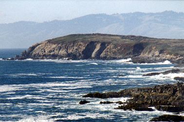
Bodega Head is the tip of the curving peninsula of land that juts out from the coast west of Santa Rosa and Sebastopol. The headlands of the head extend toward the ocean, then curve back in toward the mainland like the fingers of a hand bending inward. From a high point on Bodega Head you can wave to a wide audience that includes the expansive Pacific, the sheltered harbor at Bodega Bay, the northern tip of Point Reyes, and the rolling hills and farms of western Sonoma. On a clear day, this view is unparalleled.
The clear day is the tricky part. Bodega Bay is almost as famous for fog as it is for the Hitchcock thriller The Birds. When the fog finally clears from Bodega Bay, the coastal wind is often daunting. But there's a way to beat the system: Plan your trip for autumn or winter, and arrive in the morning, not the afternoon. This gives you the best chance for a sunny, windless hike.
Start your trip at Bodega Head's west parking lot (bear right at the fork as you drive in). The view from the parking area is mesmerizing enough. The sea crashes against dark sandy beaches, rugged bluffs, and rock outcrops. Tenacious sea palms grip the offshore rocks, holding on for dear life as each passing breaker explodes into spray. As soon as the wave dissipates, the plants spring back to an upright position, as if made of rubber.
Take the signed Bodega Head Trail from the north side of the lot. It climbs uphill on grassy bluffs to the highest point on Bodega Head, where a 360-degree vista is yours for viewing. An optional left fork at the start of the trail leads a short distance to the sandstone bluffs' eroded edges. This colorful miniature badlands looks like something straight out of Death Valley.
Follow the main path uphill to a signed junction. Take the left trail for Horseshoe Cove Overlook; the right fork continues to Salmon Creek Beach and Bodega Dunes Campground. The overlook trail dead-ends at a high, rock-covered point. There you can look down at rightfully named Horseshoe Cove and the University of California Marine Laboratory alongside it. To the east is the town of Bodega Bay and a cavalcade of RVs lined up along Doran Park on the sand spit protecting Bodega Harbor. It's fascinating to watch the fishing boats cruise slowly through the harbor, squeeze through the narrow channel between Doran Park and Bodega Head, then motor out to freedom in Bodega Bay.
When you've soaked in the view, retrace your steps to the parking lot and follow the trail that begins to the left of the restrooms. This footpath circles around the "closed hand" shape that is Bodega Head. It climbs initially to a memorial site for Bodega Bay's commercial fishermen, then hugs the edge of the bluffs as it curves around the Head's south side. On windy days, hikers can take refuge in a stand of cypress trees.
At the southern tip of the Head, you see what looks like an island rising from the sea. It's Tomales Point, the northern tip of the Point Reyes peninsula. On the clearest days, tiny Bird Rock Island is also visible, just off Tomales Point's coast. Geographically speaking, Point Reyes is directly south of Bodega Head. The two peninsulas are separated by only five miles of sea, although Point Reyes's peninsula is immense in comparison to tiny Bodega Head. If you have visited the tule elk preserve at the northern tip of Point Reyes or hiked the Tomales Point Trail, you were standing just opposite here looking north at Bodega Head. (See Hike 12 in the Marin chapter.) your trail turns away from the sea, make a choice: You can continue on a loop past the east parking lot and back to your car, or simply turn around and retrace your steps. The latter option is the most scenic. You'll enjoy Bodega Head's crashing surf, offshore outcrops, and secluded coves all over again.
Options:
After visiting Horseshoe Cove Overlook, follow the fork in the trail that is signed for Salmon Creek Beach and Bodega Dunes Campground. After crossing over the access road to the U.C. Marine Laboratory, you'll drop down to the start of a loop trail that traverses the dunes of South Salmon Creek Beach. Take the right fork, Upper Dunes Trail, and head northward. Several cutoff trails allow you to turn left and join the Lower Dunes Trail at different points, so just hike as far as you wish, then return on Lower Dunes. You can add on up to four miles on the Dunes loop. The loop can also be accessed from West Side Trail off West Shore Road, or from Bodega Dunes Campground.
Trip Notes:
There is no fee. Dogs and bikes are not allowed. A trail map is available for $1 at park headquarters at Salmon Creek or at the kiosk at Wright's Beach. For more information, contact Sonoma Coast State Beach, Bodega Bay, CA 94923, 707/875-3483 or 707/865-2391, website: www.parks.sonoma.net