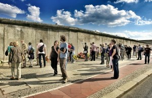
  RunsburgRunsburg is a divided city on the border of Friland and Hiveria, and has been so since the Fourth Frilandic-Hiverian War (1881). The western part (Fri: West-Runsburg / Hiv: Runsbourg-Ouest) belongs to the Frilandic Walamark shire and the eastern part (Fri: Aust-Runsburg / Hiv: Runsbourg-Est) to the Hiverian Solaria province, better known as the disputed territory of East Walamark. Runsburg is divided in two by the restricted zone (Fri: þa spargurdil / Hiv: la zone interdite), also called "the scar" (Fri: þa nar / Hiv: la cicatrice). In most places it consists of a wall, barbed wire, minefields and/or other blockages. All buildings in the forbidden zone have been demolished. Due to the many wars that have been fought over the area, there aren't many old buildings left in the rest of Runsburg either, although many historical monuments have been reconstructed, especially in the western part. The city has 280,680 inhabitants, of which 128,570 in West and 152,110 in East Runsburg. The population is largely Frilandic. In East Runsburg, about 30% of the population consists of Hiverian settlers. 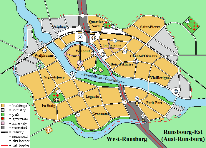 Important locations Important locations are marked on the map with a number, these are described below. 1. Checkpoint Birch Lane This border crossing on the Birch Lane (Fri: Berkangat / Hiv: Avenue des Bouleaux) is the northernmost of the three checkpoints in Runsburg. An incident at this location led to the Fifth Frilandic-Hiverian War (2009), also known as the "Birch Lane War". 2. Checkpoint Market Square The border crossing at the Market Square (Fri: Merkatrum / Hiv: Place du Marché, see no. 19) is located on the bridge between Waiþhuf and Louisienne, the centers of West and East Runsburg respectively. 3. Checkpoint Highway 1 Highway 1 (Fri: Storban 1 / Hiv: Autoroute 1) is an important artery that crosses the entire archipelago from west to east. Due to the strict controls at this point, so many traffic jams occur that this crossing is often nicknamed "Checkpoint the Campsite" (Fri: Markhald þa Biwak / Hiv: Poste-frontière le Camping). 4. Heroes' Square Heroes' Square (Haleþanrum) is dedicated to the more than 20,000 Frilandic soldiers who fell during the defense of Runsburg in the Fourth Frilandic-Hiverian War (1881). On the square is the 19th century station of (now West) Runsburg. On a journey from here to Hiveria, one has to leave the train, go through border control on foot and then take a new train at East Runsburg station. 5. Old Square The Old Square (Aldarum), which houses the town hall of West Runsburg. 6. Department store Gudjer During the Fifth Frilandic-Hiverian War (2009) a platoon of Sturmridars managed to hold on here for more than a week, surrounded by the Hiverian army. It was the only part of Runsburg that didn't fall into Hiverian hands.
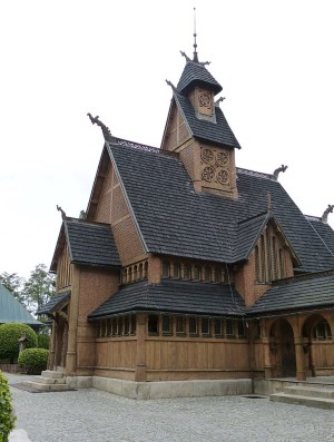
The Aesir temple (Ansanwi) is a Ferna Sed temple, named after the divine family of the Aesir. 8. King Þeudrik Square with Victory Column King Þeudrik Square (Kunung Þeudrikrum) is a busy traffic junction. In the middle of this is the 19th century Victory Column (Segsul) in honor of the Frilandic victory in the Third Frilandic-Hiverian War (1448). 9. Three Bullet Monument The Three Bullet Monument (Þrekulmendmark) stands near a railway embankment on which during the Fifth Frilandic-Hiverian War an encircled group of Rikshar soldiers held out for days against a much larger Hiverian force. When they ran out of ammunition, a negotiator came to demand their surrender. Their response was: 'Wiz haban nund þre kulan fur jiz!' ('We still have three bullets for you!'). After this, the Hiverians stormed the railway embankment and killed the last Frilandic defenders, while suffering exactly three losses on their side.  10. Walþhusan Stadium
The Walþhusan Stadium (Wadhreng Walþhusan) is home to the FF Runsburg football club. The old stadium at that location was destroyed by rioters in 1985 during a match between Frilandic FF Runsburg and Hiverian Olympique Runsbourg, which was actually intended to bring the two halves of the city closer together. 11. Bethlehem Church The Protestant Bethlehem Church (Beþlahaimkirik). The cemetery of the church is adjacent to that of the Vanir temple. There is also a section for non-believers and people of other religions. 12. Vanir temple The Vanir temple (Wenanwi) is a Ferna Sed temple, named after the divine family of the Vanir. 13. Our Lady Church In the Roman Catholic Church of Our Lady (Unsar Leuba Frokirik) is the tomb of Saint Matthew Simons son (Wi-Maþþaiu Seimonssun); a local saint and missionary from the 12th century. 14. Bokanburg barracks The accommodation of the Border control (Markhod) and a detachment of the professional army (Rikshar). 15. Hotel Skaun Utseg Hotel Skaun Utseg ("Beautiful View") overlooks Gronwatar Park. Well-known guests who stayed here were John F. Kennedy, Konrad Adenauer, Nikita Khrushchev and Walter Ulbricht. 16. Opera Square The Opera Square (Hiv: Place de l'Opéra / Fri: Objarrum) is named after the opera house that used to be on the west side of the square and was demolished in 1920 to enlarge the restricted zone. East Runsburg station and luxury department store Galerie de Bonheur are located on this square. 17. Saint John the Baptist church The Roman Catholic Saint John the Baptist church (Hiv: Église Saint-Jean Baptiste / Fri: Wi-Johan þa Daupjarkirik) stands on the site of the Haimdal temple (Haimdalwi), which was demolished by the Hiverian authorities in 1883. The surrounding cemetery was also cleansed of "heathens". Since 1967 the cemetery has been been re-opened to non-Catholics. 18. Rue de Jaquin The most important shopping street in East Runsburg, where the more expensive brands can be found (Fri: Sjakinstrat, formerly: Utangurdil (Outer Boulevard)). 19. Market Square The Market Square (Hiv: Place du Marché / Fri: Merkatrum) is popular with tourists due to the good restaurants that are located there. The town hall of East Runsburg can also be found here. The Market Square made international headlines on September 18, 2009, shortly after the Fifth Frilandic-Hiverian War, when king Waldrik gave a speech there to "support his people in occupied East Walamark". For this he crossed the border to East Runsburg without Hiverian permission, but the surprised border guards didn't dare to intervene. 20. Resurrection Church The Roman Catholic Resurrection Church (Hiv: Église de la Résurrection / Fri: Ristkirik) suffered heavy damage during the Fifth Frilandic-Hiverian War (2009). The destroyed part has been replaced by a modern glass construction by architect Daniel Jeanneret. 21. Sultan Ahmet Mosque The Islamic Sultan Ahmet Mosque (Hiv: Mosquée du sultan Ahmet / Fri: Sultan Agmeþ Mosk) was built in 2004 on the ruins of the Medieval Eastern Gate (Hiv: Porte Est / Fri: Austardur). It is the second largest mosque in East Walamark; the largest is the Al-Abyad Mosque in Solaria (Sugila). 22. Frilandic Terror and Genocide Memorial Center The Frilandic Terror and Genocide Memorial Center (Hiv: Centre commémoratif de la terreur et du génocide Frilandais / Fri: Mendmark Frilandiska skrekarai and ardmurþ) was built in 2010 on behalf of president Collignon. Part of the center is a huge cemetery for "the Hiverian victims of Frilandic war crimes and genocide". According to critics, however, the graves mainly contain fallen soldiers and people who died of natural causes. In Friland, the memorial center is therefore mockingly called "Collignon's fantasy monument" (Kollinjons telmendmark). Hiverian schools are required to visit the center annually. 23. Olympia Stadium The Olympia Stadium (Hiv: Stade Olympique / Fri: Olimpijawadhreng) is home to the Olympique Runsbourg football club. The square around the stadium is the Place Olympique (Fri: Olimpijarum). 24. Stenfort prison Stenfort (Fri: Stainfurd) is a notorious prison for dissidents and Frilandic separatists. According to ex-guard and whistleblower Julian Neige, torture is used during interrogations, which is denied by the Hiverian government. Human rights organizations regularly demonstrate at the gate. 25. Ruined castle Beaujardin Beaujardin (Fri: Skaungard) is a 14th century castle that was destroyed during the Fourth Frilandic-Hiverian War (1881). The ruin is in the restricted zone and can therefore not be visited. Neighbourhoods Hereunder you can find a list of all neighbourhoods in Runsburg.
East Runsburg: History Early history Runsburg ("river stronghold") originated around the year 300 on an island in the Swenþflaum. For many centuries it served as a center of power of local nobility. Around the year 800 king Gisalberht often came there to hunt in the nearby Dannanwalþ. The name of the Waiþhuf (Hunting Court) district still refers to this. During the Second Frilandic-Hiverian War (1142), Runsburg was temporarily occupied by Hiverian Crusaders, but soon liberated again by Frilandic forces under king Tiswald. In 1386, Hiveria annexed the city along with the rest of Walamark. During this period, a large part of the population was converted to Christianity. In the Third Frilandic-Hiverian War (1448) the city was liberated by a Frilandic army under king Þeudrik, followed by religious violence between Ferna Sed supporters and Christians. King Þeudrik put an end to this and had all destroyed temples and churches rebuilt. Runsburg experienced strong growth in the second half of the 15th century: duke Hludwig Helmarssun built the Hludwigshaim district, nowadays Louisienne, which was named after him. The hunting domain of Helmarlau, named after his father and nowadays called Bois d'Almire, was also quickly built up. 19th century A second growth spurt followed in the 19th century: on Gallows Hill (Galghau), where the riffraff used to be hung, the first industrial site was built. Southeast of that the train station was realised. On the west bank of the Swenþflaum the new Sigandsþurp district arose, named after the king at the time, and also on the Legawis city meadow the first buildings were placed. Due to the strong population growth and the attraction of the industry, even this wasn't enough; soon the districts of Nurþwik (Quartier Nord), Walþhusan, Fugalsang (Chant-d'Oiseaux), Gronwatar, Lutilhaban (Petit-Port) and Þa Staig also emerged. Within a century, Runsburg grew from a provincial town into one of the largest cities in Friland. A city divided The Fourth Frilandic-Hiverian War (1881) was disastrous for the city; Runsburg came to lie in the front line and fell victim to enormous devastation. Hundreds of inhabitants died and a large part of the historic city was destroyed. The peace that was enforced by the British Empire turned the front line into the new border, splitting Runsburg into a western, Frilandic part and an eastern, Hiverian part, separated by walls, minefields and barbed wire. This situation continues to the present. After the war the city had to be largely rebuilt. In West Runsburg the historic architecture was almost completely reconstructed, except for the area around the Aesir temple (No. 7 on the map), which was turned into a park. In East Runsburg, only parts of Louisienne (Hludwigshaim) and Bois d'Almire (Helmarlau) were reconstructed, with the exception of buildings with a distinctly Frilandic architectural style. The rest of the destroyed buildings were replaced by new construction in Hiverian style. 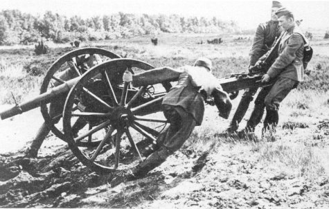 Artillery east of Runsburg, June 8, 1881. 20th century In the first half of the 20th century, East Runsburg in particular grew due to the arrival of Hiverian settlers, for whom the Saint-Pierre and Vieillevigne districts were built. However, the Hiverian government failed to attract enough settlers. Because of this, Frilanders remained the majority of the East Runsburg population. The tensions that arose between the two ethnic groups are still clearly felt today. From the 1970s onward, large groups of immigrants were also settled in East Runsburg, especially from North Africa and the Middle East. As a result, the Chant-d'Oiseaux (Fugalsang) district in particular acquired a strong multicultural character. 21st century An incident at checkpoint Birch Lane (No. 1 on the map) caused the outbreak of the Fifth Frilandic-Hiverian War (2009). West Runsburg fell after two days of fighting, but was already liberated nine days later by a Frilandic army under king Waldrik. Because the fighting mainly took place west of the city, Runsburg suffered little damage. However, in East Runsburg dozens of people were killed in acts of revenge between Frilandic and Hiverian citizens. The end of the war was followed by a fraudulent referendum, causing East Walamark, including East Runsburg, to remain in Hiverian hands. Because of this, the city remained divided. 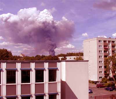 Fire in West Runsburg, seen from hotel Skaun Utseg.  |