  Hiverian KumangaGeneral information Hiverian Kumanga is an autonomous region of the African country Kumanga Yala, south of the Yagan plain, bordering the Wahadi tribal territory. It does not belong to Hiveria but is home to a large Hiverian minority, that settled here in the time that Kumanga was still a Hiverian colony. Because of this, the area is still called "Hiverian Kumanga". However, the official name of the area is Chavon, a Frenchization of Kumangan Nchi Vumbi ("Dusty Land"). The region is about the size of Luxemburg. The coastal strip is relatively fertile, but the rest of the area belongs to the sandy, barren Yagan plain. Those who visit Kumanga, usually land at the national airport in Port-de-Vivre, from where smaller flights, train and bus lines lead to other parts of the country. 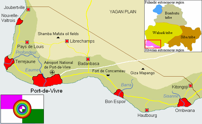 Government The regional parliament (Conseil Régional or "Regionale Raad") is led by governor Jean-Baptiste Gaillard. The Conseil Régional is formally subordinate to the national parliament, but in reality it has more influence in the region than the generally mistrusted government. In the national parliament the Hiverian minority is represented by the Parti pour le Bien-être de Kumanga Hiverienne ("Party for the Well-being of Hiverian Kumanga"), The PBKH is divided between a wing that want to keep the current status and a wing that wants a higher degree of autonomy. A minority of this supports unification with the Republic of Hiveria as an overseas territory. The region has its own media, jurisdiction and laws, even though these are subordinate to the Kumangan constitution. It also has its own flag (Hiverian purple combined with Kumangan green, the rainbow circle represents the cultural diversity of the area) and the Hiverian Franc is an accepted currency besides the Kumangan Owó. Population Hiverian Kumanga has about 304,000 inhabitants (10% of the total Kumangan population) and consists of Hiverians (40%), people of mixed heritage (25%), Wahadi (30%) and other ethnic groups (5%) Most of the Hiverian population lives along the west coast, in the area between Joubertville and Port-de-Vivre. In the rest of the autonomous region there are also large Hiverian communities, but these days they are a minority there. Especially the area between Badanbasa and Ombwana has had a large influx of Wahadi immigrants during the last decades. Mainly Christians, who have a lot to endure from radical Islamitic Ilaorun militias in the Wahadi tribal territory. Language and religion About 55% of the population speaks Kumangan French as its first language, 40% Kumangan (mainly Wahadi) and 5% other. Many children are being raised bilingual, with French as first language and Wahadi as a second language (or vice versa). Also in the rest of the country, especially in the big cities, Kumangan French is still frequently used as a universal language. The most important religions are Catholicism (60%), Islam (20%) and other (15%). 5% of the population is atheist. Culture The Hiverian minority in Kumanga is characterized by its humble attitude towards the past. Once it held sway over the Hiverian colony of Kumanga, conducted slave trade and lived in luxurious villas with servants. But all that remains for them in the new, independent Kumanga is a modest role and much shame about this period, which is still a very sensitive subject amongst many Kumangans. A large part of the Hiverian minority has therefore adapted to Kumangan culture as much as possible, and prefers to forget about its Hiverian roots. Still, many traces of Hiverian culture remain in this area. Besides some Hiverian holidays, Uhuru is also celebrated on August 14, the Kumangan independence day. Even though this date marks the end of Hiverian rule over the island, the Hiverian minority now celebrates it as the beginning of a new chapter in its existence, in which henceforth all inhabitants of Kumanga are free and equal. Typically Hiverian in this area, are the café's, wine tastings and restaurants. The music styles and local cuisine also have a distinct Hiverian origin. Furthermore, the city of Nouvelle-Valtrois is known for its many art studios. Famous Hiverian Kumangan painters are, amongst others, Banambo Valois, Jacqueline Gauthier, Remy Mbulangwe and Jean-Michel Savreux.
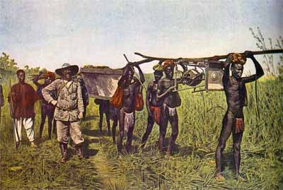
Police and militia troops Because of the political instability and far-reaching corruption within the police and the army, the region got permission in 2008 to have its own police force; the gendarmerie local ("local police"). Which is under direct control of the Conseil Régional in Port-de-Vivre. The protection of the Hiverian autonomous region is a task of the Kumangan government forces. However, because these do not succeed in stopping the attacks of Ogunti and Ilaorun rebels, civilians have created the Milice Régionale de Kumanga Hiverienne ("Regional Militia of Hiverian Kumanga"). The MRKH sometimes collaborates with the Kumangan government army, but is not formally under control of the national or regional parliament. Its units usually operate by themselves and answer only to Alexander Lacroix, nicknamed "Le Commandant". This former officer of the Kumangan government army is notorious for his brutal actions against the rebels that prowl the area, which is why he is wanted by the authorities but well-beloved by the people. The MRKH is made up of groups of civilians and paramilitaries with a varying degree of training, discipline and armament, from farmers with hunting rifles to former servicemen. Although the troops of "Le Commandant" have a couple of helicopters and armoured cars at their disposal, they mainly use SUV's, motorcycles and foot patrols. History In 1634 Hiveria received permission from the Wahadi to build a trading post in their territory, at the southeast coast of the island. Hiveria then built a fortress named Port-de-Vivre, that became not only a trading post but also a base of operations, from where the rest of Kumanga would be brought under Hiverian control. In the following years new settlements were founded, like Terrejaune, Nouvelle-Valtrois and Bon Espoir. Existing Wahadi villages like Badanbasa and Ombwana were also placed under Hiverian control. The territory of this early Hiverian colony was roughly the same as that of the current Hiverian autonomous region. The area attracted many colonists and was actively converted to Christianity, in which the missionaries were not limited to the colony itself, but also preached in the Wahadi and Siba territories. Especially in the land of the Siba they managed to make many converts. Hiverian influence in the Wahadi and Siba area territories grew to such a degree, that the country began to regard these areas as its property and started collecting tax there. This led to the so-called Tax Rebellion, in which the Siba and Wahadi made a joint attack on the Hiverian colony and looted Ombwana and Bon Espoir. However, the fortress of Port-de-Vivre, which had by that time grown into a large, fortified city, managed to hold out. Hiveria then sent reinforcements from Europe, that used the Tax Rebellion as an excuse to conquer most of Kumanga. In 1661 the entire island formally became a Hiverian colony, even though Hiveria's actual authority remained limited to the lands of the Siba and the Wahadi, while in the north the Frilandic trading post and the Bombutu territory remained mostly independent. Port-de-Vivre, by that time the capital of the Hiverian colony of Kumanga, developed into an important port and slave market. Excluding the Hiverian Revolution (1794) and the Fourth Frilandic-Hiverian War (1881), there were three centuries of relative peace in the colony. On August 14, 1961 Hiverian president Lejeune gave Kumanga its independence. In the new, democratic Kumanga the southeast, which was mainly populated by Hiverians, became an autonomous region. The First Kumangan Civil War (1969-1970) ended the democracy and the capital was relocated from Port-de-Vivre to Malibe. The civil war caused a large devastation in the area and many citizens of Hiverian origin were killed or fled the country, which is why the percentage of Hiverians in the region is much lower these days. In 2001 the democracy was reinstalled, but because of the constant threat of Ogunti and Ilaorun militias, the situation in the country remains very tense. More information: general history of Kumanga. 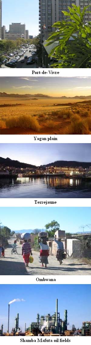 Settlements:
Port-de-Vivre ("Lively Harbour", Kumangan: Kwilabango) The former capital of Kumanga. Founded as a fortress, harbour and trading post, but nowadays one of the country's biggest cities. Terrejaune ("Yellow Earth", Kumangan: Kumala) Here the national oil reserve, a big harbour and an important naval base are located. Nouvelle-Valtrois ("New Valtrois", Kumangan: Mboulowa) In 1794 the Hiverian revolutionary army was defeated here by the colonial forces of the royalist governor Joubert. Badanbasa Originally a Wahadi city that was annexed by Hiveria. These days it houses a large Hiverian minority. Bon Espoir ("Good Hope", Kumangan: Banakisi) Known for its many bonbon shops and active music scene, with Hiverian chansons and Kumangan Mbiliwimbo music. Ombwana This Wahadi city was long under Hiverian influence, but since the First Kumangan Civil War the Hiverian population and culture have virtually disappeared here. Joubertville ("Joubert city", Kumangan: Mabouko) This border town is named after the popular governor Raoul Joubert. Between 1794 and 1926 this place was named Gaudinville, after the first Hiverian president. This because it was common after the Hiverian revolution to remove all references to former nobility. Pays de Louis ("Land of Louis", Kumangan: Bibonga) Named after king Louis I Concarneau. Between 1794 and 1926 the village was named Pays de Peuple ("Land of the People"). Librechamps ("Free Fields", Kumangan: Mashamba Huru) This village is located on the inhospitable Yagan plain. It's mainly populated by labourers, who work at the oil fields of Shamba Mafuta. Hautbourg ("Highborough", Kumangan: Kilima Ngome) This fishing village has surface rock layers from the Precambrian, which is why interesting fossils can be found here. Kitongoji This border town has long been an outpost of the Hiverian colonial army. Because the village was home to many beautiful Wahadi women, many soldiers converted to Islam to be able to marry them. Other locations: Aéroport National de Port-de-Vivre (Kumangan: Kwilabango Uwanja wa Ndege) The biggest and most important airport of Kumanga. Shamba Mafuta oil fields The oil industry at Shamba Mafuta is one of the pillars of the Kumangan economy and provides much employment in the Hiverian autonomous region. Fort de Concarneau This early 18th century fortress is now a museum. Giza Mapango Giza Mapango ("Dark Caves" in Kumangan) is a cave system of many kilometers across. It houses not only interesting animals, but traces of prehistoric human presence have also been found. Sometimes the caves are also used by smugglers. Yagan plain This barren plain covers more than one third of Kumanga and is the homeland of the Wahadi tribe. Barra (Kum. Agbara: "To flow") (river) Eaume (Kum. Omi: "Water") (river) Profondeur (Fr. "Depth", Kum. Ijinle) (river) Sisanne (Kum. Sisan: "To stream") (river)  |