Leaving Athens, there are two major bus stations and they are sometimes confused. Once you realize which one goes to mostly Peloponnesian destinations (the station at 100 Kifissou-take bus 51 from Omonia Square and it takes 15 min. to get there), get there early enough to make it to where your going quickly so you'll have some time the rest of the day.
Beyond Eleusis, the main highway splits right toward Thebes and left towards Megara and then Corinth. Megara was a city of great strategic importance and the city's favors were hotly fought over by the Athenians and the Spartans in the Peloponnesian War. Archaeologically little has been found here though. Some city wall remains as well as some towers have been discovered, but the archaeological collection is contained in the local High School.
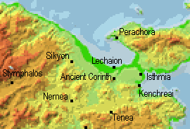
Passing through the Plain of Megara, the Yerania Mountains are skirted, but a wonderful view of the Saronic Gulf is seen to the left. On the peninsula that juts out to the north before you reach the canal, you can turn towards Loutraki, a resort town with hot baths known to the ancients as Thermae, and Perachora, the site of a beautiful sanctuary of Hera (do not miss out on the spectacular photo opportunities here!). You soon approach the Corinth Canal and the ancient Diolkos of Corinth, where in ancient times ships were hauled across the isthmus over a stone roadway. Unfortunately most of the Diolkos was destroyed when the modern canal was constructed. Ancient attempts to cut a canal were begun, but none ever made it very far. Pausanias (2.1.5) described some of the undertakings. (Here I bypassed Corinth at first and headed straight for the Argolid, which we will skip for now, since it doesn't make sense geographically to do it first).
 Just
to the east of Corinth is the ancient site of Isthmia,
which is worth a visit if you can get there, as Pausanias (2.1.7)
recommends. The
archaeological museum of Isthmia has some wonderful sculpture and votive
objects (dedications), but it is obviously not as frequented as the one
at Corinth. Isthmia was the site of a sanctuary of Poseidon and every
two years
Just
to the east of Corinth is the ancient site of Isthmia,
which is worth a visit if you can get there, as Pausanias (2.1.7)
recommends. The
archaeological museum of Isthmia has some wonderful sculpture and votive
objects (dedications), but it is obviously not as frequented as the one
at Corinth. Isthmia was the site of a sanctuary of Poseidon and every
two years 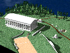 games
were held there similar to those at Olympia and Delphi. You can learn
more about their theater
online. Thanks to the Classics Department at Ohio State University
and our friends at the American School of Classical Studies at Athens,
the excavations at this important site have been placed online. The
Ohio State University Excavations at Isthmia have proven to be a model
online site for excavations across the world. But they are not just
for scholars. Take a look and see if you can learn something here.
I cannot leave out the University
of Chicago Excavations at Isthmia. These two departments work
hand in hand to uncover this large site and they have done some really
nice work at their online site also. Of interest to many might be
the Computer
Generated Reconstructions of the Sanctuary of Poseidon.
games
were held there similar to those at Olympia and Delphi. You can learn
more about their theater
online. Thanks to the Classics Department at Ohio State University
and our friends at the American School of Classical Studies at Athens,
the excavations at this important site have been placed online. The
Ohio State University Excavations at Isthmia have proven to be a model
online site for excavations across the world. But they are not just
for scholars. Take a look and see if you can learn something here.
I cannot leave out the University
of Chicago Excavations at Isthmia. These two departments work
hand in hand to uncover this large site and they have done some really
nice work at their online site also. Of interest to many might be
the Computer
Generated Reconstructions of the Sanctuary of Poseidon.
Corinth: (22,658 inhab.) Here is a word to the wise, if you are ever taking the bus from Pirgos to Athens and plan to get off in Corinth, know what you're doing! They just dropped us off on the side of the main highway ("Corinth here!" said the driver), a few kilometers from the main part of town! Again, here is when asking children questions paid off (it's much more likely that they will know English). The town was not that bad, but the accommodations we wound up with (the Hotel Belle-Vue, "central if a little shabby" according to the Rough Guide) were the worst I saw in all of Greece. I really was worried that every step I took could have ended up with my leg hanging down into the next room, me shouting, "a little help here." It is a tip-off that you better go elsewhere when the hotel clerk answers all your questions with the construction "yesno." UPDATE - I have just received an email (July 99) that the Hotel Belle-Vue is now closed. Thank goodness! As for other accomodations, though I did not stay there, there is a web site on the Corinth Youth Hostel.
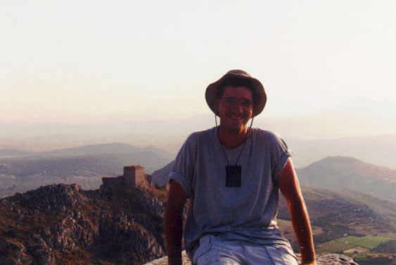
Ancient Corinth was worth the trouble though. It is a short ride up the hill from the modern city so you will have to go to the right station and take a bus up to the site (through some very narrow streets - those Greek bus drivers really are amazing!). The archaeological site of Ancient Corinth is fantastic (the entire site is photographed and explained here) and the archaeological museum of Ancient Corinth has some great sculpture and mosaics. The layout of the Roman city is not too confusing (here is the Corinthian Bouleterion). Take your time here though. Be sure and see the Peirene Spring (Pausanias 2.3.3), as well as the theater on the other side of the road. On my second visit I made it up to the Acrocorinth. We went to the very top, at the remains of the Temple of Aphrodite; quite a walk! Here is a photo of me at the peak of Acrocorinth. The view behind me is looking out southwards to the Peloponnese. Do not be too worried, but do be on the lookout for snakes. If you stay on the paths you should not have much to worry about though. Another reason not to wander off in the bushes are the numerous cisterns. Many of these ancient water gathering pots have not been covered up yet and you might just step off into one of them. The ancient fortress atop the mountain has a cafe, the Acrocorinthos, which has some rooms to let. But you had better call ahead since there are not very many available. From the top of Acrocorinth, and on a clear day, you can see all the way to Aegina and the Athenian Acropolis as well as the entire Gulf of Corinth to the west. Strabo visited this site and described it almost two millennia ago, but you can still read what he wrote (8.6.21) about the view and the city below. There is also a scholarly electronic journal about Corinth and the surrounding area that is available online: the Korinthiaka. You can find a plan to reconstruct the Roman city of Corinth, online of course, at the Corinth Computer Project located at the University of Pennsylvania.
Kenchreai: Kenchreai, the eastern port of Corinth which is a little south of Isthmia, is also an important archaeological site (Pausanias 2.2.3) whose excavations are available online thanks to Kathryn Conners, though in a more abbreviated format than some of the other sites. It was important during the classical period due to the walls that ran from Corinth to the Saronic Gulf here and in Roman times it served as an important port for the area.
Sikyon is also nearby and it has a nice but small theater (Pausanias 2.7.5).
Heading South: Once the heights of Acrocorinth have passed from view, the bus rides along the side of a valley (crossing the same set of train tracks numerous times), eventually passing the ancient village of Tenea, and then the major site of Nemea, famous for its sanctuary of Zeus. You can visit my separate site on Nemea, which I have just recently finished.
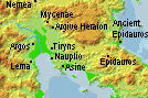
(Follow the link.) In the Argolid section,
you will find information on Mycenae, Argos, Nauplio, Tiryns, Epidauros,
and others. I will also skip over Tegea
here (though it lies between Argos and Sparta), because
it is officially part of Arkadia. I have a separate page for it anyway.
Sparta: (11,911 inhab.) 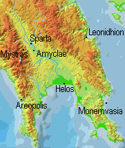 The
old route from Argos to Sparta (through Tripoli) is full of surprises.
Hairpin turns in the Kleisoura Pass and great views make it worth your
while as long as your not driving. The new national road from Argos
to Tripoli is a smooth modern highway with a lengthy tunnel. I had
the good luck to have gone through both, but I will admit that though the
new road cuts down on time and is much safer, the old one had its charm.
The modern town of Sparta (est. 1834) is a little south of the ancient
one, of which there is very little left. It sits below Mount Taygetos
and is described by Strabo (8.5.1).
If you are hoping for large monuments or temples, you probably have not
reviewed your history lately. We all remember that quote of Thucydides,
right? The town itself has a nice archaeological
museum, which has a collection with some pottery, very nice mosaics,
a few great pieces of sculpture, and many interesting votive objects.
The archaeological site, is reached via a beautiful tree-lined road just
north of the modern town and around the modern soccer stadium. It
might not seem that remarkable to a modern visitor, but Pausanias visited
there and gave a good description (3.11.1).
The Acropolis
of Sparta is not what you might expect, though there the remains of
a huge Roman
theater are found there (Pausanias
3.17.1). If you do visit, note the drawings of the ancient stage
in the Blue Guide, the skene would be decorated and rolled on metal rods
out of a shed adjacent to the theater. The one other site not to miss in
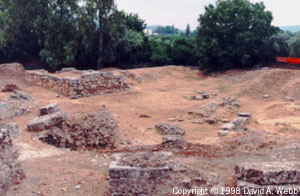
Sparta, is the Sanctuary
of Artemis Orthia. The temple (photo)
was the site of a ritual beating that young Spartan males had to endure.
Many were severely beaten and a number died. During the Roman period
a theater was constructed around the altar so that large crowds could gather
and watch the beatings! The site was excavated by the British in
the early 1900's and the
original publication is available online it its entirety!!!
One of the weirdest experiences in my visit last summer happened at the
sanctuary. We entered the site and Rosaria Munson was about to give
a presentation when small gypsy children (ages 4-6) began to take an interest
in us. They came into the site and began walking right in between
Rosaria and the group. Besides making sure our belongings were close
to us, we weren't paying too much attention until they started marching
through in order, beating their chests, removing their shirts and eventually
shouting. Rosaria just kept talking. We finally left but by
then about twenty children had shown up, raising hell, giving us the bird,
even flashing us. Wacky place. Too bad they were not there
about 2500 years ago! Just outside of town is another site that,
if you already are this far, it would be a shame to miss. I have
an entire page devoted to the Menelaion,
which was a shrine/temple devoted to Helen and Menelaos (and there is also
a Mycenaean Palace there!).
The
old route from Argos to Sparta (through Tripoli) is full of surprises.
Hairpin turns in the Kleisoura Pass and great views make it worth your
while as long as your not driving. The new national road from Argos
to Tripoli is a smooth modern highway with a lengthy tunnel. I had
the good luck to have gone through both, but I will admit that though the
new road cuts down on time and is much safer, the old one had its charm.
The modern town of Sparta (est. 1834) is a little south of the ancient
one, of which there is very little left. It sits below Mount Taygetos
and is described by Strabo (8.5.1).
If you are hoping for large monuments or temples, you probably have not
reviewed your history lately. We all remember that quote of Thucydides,
right? The town itself has a nice archaeological
museum, which has a collection with some pottery, very nice mosaics,
a few great pieces of sculpture, and many interesting votive objects.
The archaeological site, is reached via a beautiful tree-lined road just
north of the modern town and around the modern soccer stadium. It
might not seem that remarkable to a modern visitor, but Pausanias visited
there and gave a good description (3.11.1).
The Acropolis
of Sparta is not what you might expect, though there the remains of
a huge Roman
theater are found there (Pausanias
3.17.1). If you do visit, note the drawings of the ancient stage
in the Blue Guide, the skene would be decorated and rolled on metal rods
out of a shed adjacent to the theater. The one other site not to miss in
Sparta, is the Sanctuary
of Artemis Orthia. The temple (photo)
was the site of a ritual beating that young Spartan males had to endure.
Many were severely beaten and a number died. During the Roman period
a theater was constructed around the altar so that large crowds could gather
and watch the beatings! The site was excavated by the British in
the early 1900's and the
original publication is available online it its entirety!!!
One of the weirdest experiences in my visit last summer happened at the
sanctuary. We entered the site and Rosaria Munson was about to give
a presentation when small gypsy children (ages 4-6) began to take an interest
in us. They came into the site and began walking right in between
Rosaria and the group. Besides making sure our belongings were close
to us, we weren't paying too much attention until they started marching
through in order, beating their chests, removing their shirts and eventually
shouting. Rosaria just kept talking. We finally left but by
then about twenty children had shown up, raising hell, giving us the bird,
even flashing us. Wacky place. Too bad they were not there
about 2500 years ago! Just outside of town is another site that,
if you already are this far, it would be a shame to miss. I have
an entire page devoted to the Menelaion,
which was a shrine/temple devoted to Helen and Menelaos (and there is also
a Mycenaean Palace there!).
Mistras: A few miles to the west is the monastery town of Mistras (now only a few buildings are still used) from the middle ages. Founded in 1249 A.D., the main castle was an attempt to give the Franks a good position with which they could control the local Greeks. They soon were forced to give the site to the Greeks and then the Byzantine State of Mistras thrived until modern Sparta was repopulated in the 19th century. It is quite large and the last emperor of Byzantium was even crowned here. Mistras is worth the visit if you are in the neighborhood, and indeed is the only reason why many visitors even make it to Sparta at all. The site was also designated a World Heritage Site by UNESCO in 1989. They have a small, but cramped, Archaeological Museum of Mistras. The biggest structure, the Palace of Despots (pictured here), was being roofed while I was there and once covered it might make an excellent museum.
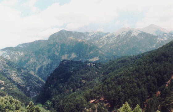
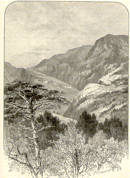
The mountains around Sparta (really just on the west) are amazing when you are first arriving. The site of Mistras is located near the bottom of their eastern slope. Most spectacular is Mount Taygetos (shown here behind the Menelaion). They also prove no small feat in crossing. The area from Sparta to Kalamata is one of the most desolate stretches of road in the Peloponnese, reaching some extremely high peaks along the way. The Langadha Pass (photo & 19th century drawing) is no easy feat to cross even on clear days and should be approached with care in inclement weather. I have to really recommend a place where we ate on the way through the pass. It is at a small village known as Trype (or Tripi). Usually these mountain restaurants are only interested in getting the tour buses to stop by giving the drivers big incentives, but this is a special place. There are two medium sized restaurants opposite each other on the road (right next to the road). I ate at the one on the left side of the road (going from Sparta to Kalamata) and had one of the best meals during my entire time in Greece. Some other from our group ate at the one on the right side (the side overlooking the cliff), and they were also quite happy with the food. There is also an extremely cold spring running through the restaurant. A great place. Also, one of my friends, Ted, swore this was the best food he had in all of Greece (he had the kid and potatoes at the same restaurant I did).
Other Laconian cities worth mentioning include ancient Amyclae (Pausanias 3.18.6) and modern Monemvasia (also known as the "Gibraltar of Greece.".
Peloponnese (part
2)