Located around a tiny cove at the furthest point of the Perachora peninsula, the shrine of Hera Acraea was probably a possession of Megara in its earliest days, but it later became a possession of Corinth. This location is also known today as Cape Melangavi but also has gone by the name of Peiraion, Peraia, Heraion, Akraea, and Akraia.
History
Strategically important to some, but scarce of water,
Plutarch records that in Mycenaean times, Perachora was under the control
of Megara. There were no substantial settlements
in the area but scattered pottery indicates the presence of a small number
of houses, possibly from a small fishing 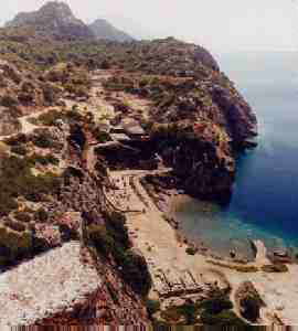 population.
It seems likely that a larger settlement may have existed somewhere on
the peninsula. There was (and still would be today if not for modern
piping techniques) a serious water problem at the peninsula's extremity.
There are no springs anywhere near the sanctuary and water must be collected
in cisterns. This, along with the relatively restricted space afforded
from the rocks, probably kept any population very limited. Under
the control of Megara, the area would have been of little importance since
their port at Pagai would have been much more important to them.
population.
It seems likely that a larger settlement may have existed somewhere on
the peninsula. There was (and still would be today if not for modern
piping techniques) a serious water problem at the peninsula's extremity.
There are no springs anywhere near the sanctuary and water must be collected
in cisterns. This, along with the relatively restricted space afforded
from the rocks, probably kept any population very limited. Under
the control of Megara, the area would have been of little importance since
their port at Pagai would have been much more important to them.
To Corinth, the
location was obviously much more desireable. During the geometric
period, the control of the the area was obtained by Corinth, and this completely
changed the character of the site. There does not seem to have been
an earlier sanctuary at the site or even a cult of Hera before the Corinthian
arrival. In about 800 BC, the earliest temple on the site, a limestone
apsidal chamber, was constructed and dedicated to Hera Acraea. The
original excavations at Perachora turned up an inordinate amount of Argive
pottery, which led many people to assume that the cult was an offspring
of the famous Sanctuary of Hera at Argos
(the origin of the goddess), but today it is still unsure how much of a
role they played. At this point in time, Corinth was still in the
shadow of Argos, whose political power
stretched over the northeastern Peloponnese. But as Corinth became
an important and independant city-state, the site of Perachora also gained
importance. As a lookout over the Corinthian Gulf all the way to
Naupactos and north towards Boeotia, it was invaluable to Corinth.
Throughout the Archaic period the site was held by Corinth and more temples
were constructed as well as a stoa, agora, and numerous other buildings.
The site's defensive importance was paramount and the two peaks (one between
the site and the lighthouse) were fortified during early classical times.
During Corinth's war with Sparta in 391-390
BCE, many Corinthians and their flocks were moved to the Perachora area
to keep them safe from marauding Spartans. The site was captured
by Agesilaos nevertheless. Xenophon describes the fighting (Hellenika,
4.5), but there was no serious damage done to the site by the Spartans.
The Hellenistic period saw the continued importance of the site (the huge
cistern with columns dates to this period), but in the Roman period it
reverted back to merely the location of a few homes. Since Roman
times the site has been deserted and robbed of its stone by nearby communities.
The Archaeological Site Today
Today the site is officially part f the prefecture of Corinth, even 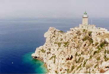 though
it is on the opposite side of the canal. Upon arrival, you will park
in a large lot above and to the north of the site. There are no periptera
or stores around, but while we were there a few old men were sitting under
a tree at the side of the lot selling fruit. From the parking lot,
the path that leads down to the site curves back to your left. But you
can go right and, following the path of the ancient road, around the hill
you will find an old lighthouse, built in 1897, that is very picturesque
(seen in photo here). Traces of polygonal walls here suggest the
remains of a fortified acropolis. I highly recommend taking a number
of pictures here, and for those of you who are able, to climb up to the
top of the peak in between the lighthouse and the archaeological site.
It will only take about four minutes to get up there, just beware of the
cisterns. Once there the view is absolutely amazing.
You have a better view of the entire Gulf of Corinth than you do at Acrocorinth.
The view back along the peninsula's coastline to the northeast is worth
a few photos also (part of this view is seen in the photo below).
This is the only place to take decent photos of the archaeological
site below, and it is the place from which I took the photo at top.
though
it is on the opposite side of the canal. Upon arrival, you will park
in a large lot above and to the north of the site. There are no periptera
or stores around, but while we were there a few old men were sitting under
a tree at the side of the lot selling fruit. From the parking lot,
the path that leads down to the site curves back to your left. But you
can go right and, following the path of the ancient road, around the hill
you will find an old lighthouse, built in 1897, that is very picturesque
(seen in photo here). Traces of polygonal walls here suggest the
remains of a fortified acropolis. I highly recommend taking a number
of pictures here, and for those of you who are able, to climb up to the
top of the peak in between the lighthouse and the archaeological site.
It will only take about four minutes to get up there, just beware of the
cisterns. Once there the view is absolutely amazing.
You have a better view of the entire Gulf of Corinth than you do at Acrocorinth.
The view back along the peninsula's coastline to the northeast is worth
a few photos also (part of this view is seen in the photo below).
This is the only place to take decent photos of the archaeological
site below, and it is the place from which I took the photo at top.
On the way down to the site, you will first arrive
at the little chapel of Agios Ioannis, moved to this spot in 1933 from
its original home directly above the apsidal temple. From here, you
can either continue down the path to the harbor or turn in the opposite
direction towards the inland part of the site. The oldest part of
the site lies below, so I will start there. Beside the harbor you
can still see the foundations of the Geometric Temple of Hera Akraia,
apsidal and made of limestone. This temple was built around 800 BC,
but cult worship at the site may predate that by a half century or more.
Pilgrims to the site made dedications by either placing objects in the
shrine or by tossing them into the water. It is quite likely that
the small house-models
found here may roughly represent the temple itself, but they were all made
in Argos, not Perachora. The temple remained in use till around 725
BCE when it either collapsed or slowly became derelict.
During the next century the site seems to have been
little used, but around 550 an archaic temple, usually referred to as the
Sixth-Century
Temple of Hera Akraia, was built slightly to the west (overlapping
the old one somewhat). This building was the largest temple on the
site and its remains are clearly seen in the lower middle part of the photo
at top. It never supplanted the temple of Hera Limenia though (see
below). Many of the foundation stones have been spirited away for
use by peasants in building their own houses, and a good part of this activity
took place in the decades preceding the first excavations, but a large
number remain. The temple itself was laid out in a peculiar way.
Inside the walls (there were no exterior columns), two short walls ran
the length of the building a few feet high. On top of these walls
stood a Doric colonnade. They were interuppted around a quarter of
the way from the back of the building where a cross wall separated the
cella from a back room, where the oracle may have been housed. The cult
statue was definitely housed in the rear (western) part of the temple as
the base of the statue has been found. Numerous exterior architectural
fragments have been found including parts of the architrave, cornice, metopes,
triglyphs, and even parts of the sima. It was topped by side akroteria
in the form of flying Nikai (a statue at each corner of the goddess Nike),
made of Parian marble and probably a group of Korai (statues of young women)
on the top. The temple stood until at least the 2nd century AD.
The designation of the two temples here as Akraia
no doubt refers to their place at the tip of the peninsula, not
on a high peak as the term is often used. Also in the lower section
of the sanctuary, you will find a 4C BC stoa cut into the cliff wall in
the shape of an "L". There are also the remains of a large, covered
altar built at a later date on top of the apsidal temple. The fine
triglyph
altar had a Doric frieze and was probably used with the sixth century
temple. Though we did not search it out, there are also the large 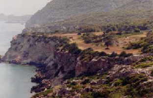 remains
of a Roman house just to the west of the modern jetty which protects part
of the cove (lower right of picture at top). I could roughly make
this out from on top of the peak above, but if you wander around down below,
take care of the underground cisterns. Another word of advice: Be
careful around the stoa. Although there are benches cut into the
walls and it provides some shade in the morning hours, there is also a
hive of hornets that live in the cliff walls. I would not worry too
much about this, just do not bring a meal to eat down in the lower section
of the sanctuary or you could get swarmed!
remains
of a Roman house just to the west of the modern jetty which protects part
of the cove (lower right of picture at top). I could roughly make
this out from on top of the peak above, but if you wander around down below,
take care of the underground cisterns. Another word of advice: Be
careful around the stoa. Although there are benches cut into the
walls and it provides some shade in the morning hours, there is also a
hive of hornets that live in the cliff walls. I would not worry too
much about this, just do not bring a meal to eat down in the lower section
of the sanctuary or you could get swarmed!
The upper part of the site is more spread out than
the lower. Past the chapel you will find a large double apsidal cistern
of Hellenistic date. To the south of this you may see the foundations
of a dining building, regularly seen in Greek sanctuaries. Further
up, you pass on the left the area of the sacred pool which has now been
filled in and another cistern behind it. It was a geometric period
construction (almost unique for its type) but it never held water long
after the rains subsided.
Climbing a few steps, you enter an upper terraced
area and at the furthest point you can make out the remains of a rectangular
building with a hearth in the middle. This was the Hera Limenia (Harbor)
Temple. It is enclosed in a large temenos whose eastern and northern
boudaries are faintly visible. The southern border is defined by
the cut away rock behind the temple and the western boundry (though lost
today) probably ran near the line of large blocks about 15 meters west
of the temple; blocks which come from a later building on the site.
No other buildings were constructed within the tenemos. The ground
within the tenemos was found to have held well over ten tons of pottery!!!!
This material came from votive offerings dedicated at the temple.
The wall directly beside the temple, which cuts across the temenos, most
likely was built in an effort to control water runoff and erosion, a terrible
problem at this particular site. This temple was probably built after
the first temple near the cove was abandoned in the 8 C BCE. and its gain
in prestige is linked to the increase in Corinthian trade at that time.
Above the foundations, the temple was probably constructed of bricks and
timber, but the extraordinarily heavy (and sturdy) roof must have had additional
support. Strabo says that there was an oracle here and many of the
offerings found in the sacred pool may have been thrown in prior to consulting
the oracle.
Other Practicalities
The beach at the site is rocky, there are sea urchins,
and one corner has a good bit of trash lying around (it looks like they have tried to burn it,
leaving an even less appealing mess) but some members of our group still
swam for a while here. The guide books say that this is safe, and
some even note the great snorkeling opportunities (but one was wrong when
it stateed that the stoa is submerged), just do not venture out too far
past the cove or you may run into dangerous currents and even sharks!
good bit of trash lying around (it looks like they have tried to burn it,
leaving an even less appealing mess) but some members of our group still
swam for a while here. The guide books say that this is safe, and
some even note the great snorkeling opportunities (but one was wrong when
it stateed that the stoa is submerged), just do not venture out too far
past the cove or you may run into dangerous currents and even sharks!
Transportation to the site is somewhat problematic
for those without a car. It is not a day trip from Athens unless
you do have your own vehicle. Buses do leave Athens for Loutraki
a few times a day, but I do not know from where or when. There is
also service from Corinth to Loutraki every half-hour. From Loutraki,
buses leave every hour for the village of Perachora, 10 km to the north.
Though I don't remember passing through the village of Perachora on route
to the site, the maps show that it is on the way, so I am sure they stop
at the village along the way. The maps read that the site and village
are 12 km apart. Another guide book states that walkers from Loutraki
can take a "delightful cliff path" (3 hours) direct to the Heraion, keeping
on the seaward side of Lake Vouliagmeni. This is the way that the
Spartan king Agesilaos took from Thermae (Loutraki) on to Perachora, the
route "para thalasson" (alongside the sea).
We were told that a week or so after we visited
Perachora a large forest fire destroyed most of the vegetation on the surrounding
hillsides, but was kept from reaching the sanctuary. This is not
suprising since there were countless wildfires in the summer of 1998, but
it is extremely unfortunate that an area of such incredible beauty was
severely damaged in this way.
Ancient Sources
Xenophon, Hell. iv. 5. (describing the Corinthian
war of 391-390 B.C.E.)
Plutarch, Cleomenes, iii. 814
Livy, xxxii. 23.
Strabo, viii, 380.
Plutarch, Q.G. 17.
Euripides, Medea 1378-83.
Pre-Excavation References
Bolte, R.E. viii. 418-9.
Le Bas-Reinach, Voyage arch. 29-30, pl. 15, 1.
Forchhammer, Halcyonia, 11ff.
Leake, Travels in the Morea, iii. 314ff.
--, Peloponnesiaca, 398-9.
Boblaye, Recherches geographiquies, 36.
Isambert, Itineraire, 64.
Bursian, Geographie von Griechenland, i. 382-3.
Curtius, Peloponnesos, ii. 552 and pl. 20.
Philippson, Der Peloponnes, 25-7.
Robinson, Corinth, i. 35-46.
Hanell, Megarische Studien, 77ff.
Modern Sources
Blackman, D.J. 1966. The Harbour at Perachora, BSA
61: 192-194.
Corso, A. 1985. Lheraion di Paro, ASAtene 62: 97-101.
Coulton, J.J. 1975. Towards Understanding Greek Temple
Design: General Considerations, BSA 70: 59-99.
--. 1972. A Tympanum Fragment at Perachora,
BSA 67: 207-210.
--. 1967. The West Court at Perachora, BSA 62:
353-371.
--. 1964. The Stoa by the Harbour at Perachora,
BSA 59: 100-131.
Dunbabin, T.J. 1962. Perachora II. The Sanctuaries of
Hera Akraia and Limenia: the pottery, ivories, scarabs and other objects
from the votive deposit of Hera Limenia. Oxford.
--. 1951. The Oracle of Hera Akraia at
Perachora, BSA 46: 61-71.
Dunn, F. 1994. Euripides and the Rites of Hera Akraia,
GRBS 35: 103-115.
Hammond, N.G.L. 1954. The Heraeum at Perachora and Corinthian
Encroachment, BSA 49: 93-102.
Legon, R.P. 1981. Megara: The Political History of a
Greek City-State to 336 B.C. Cornell.
Llinas, C. 1965. Le portique coudé de Pérachora,
BCH 89: 484-497.
Megaw, A.H.S. 1967. Perachora, Deltion 19: 107.
Menadier, Blanche. 1995. The Sixth Century BC Temple
and the Sanctuary and Cult of Hera Akraia, Perachora. Cincinnati.
Meyer, E. 1937. Peraia, RE 19, 1 cols. 565.
Payne, H. Preliminary Reports on Perachora.
--. 1930. BSA 30 (1928-30): 285-7.
--. 1930. JHS 50 (1930): 238-40.
--. 1931. BSA 31 (1930-31): 185-7.
--. 1931. JHS 51 (1931): 191-4.
--. 1932. BSA 32 (1931-32): 258-63.
--. 1932. JHS 52 (1932): 240-4.
--. 1933. BSA 33 (1932-33): 212-5.
--. 1933. JHS 53 (1933): 277-80.
--. 1934. JHS 54 (1934): 190.
--. 1940. Perachora I. The sanctuaries of Hera
Akraia and Limenia: the architecture, bronzes and terracottas. Oxford.
Picard, C. 1932. LHeraion de Pérachora et les
enfants de Medée, RA 35 (series 5): 218-29.
Plommer, H. and F. Salviat. 1966. The Altar of Hera
Akraia at Perachora, BSA 61: 207-15.
Salmon, J. 1972. The Heraeum at Perachora and the Early
History of Corinth and Megara, BSA 7: 159-204.
Sinn, U. 1990. Das Heraion von Perachora: eine sakrale
Schutzzone in der korinthishen Peraia, AM 105: 53-116.
Tomlinson, R. 1994. Perachora, in Placing the Gods:
Sanctuaries and Sacred Space in Ancient Greece, eds. S.E. Alcock and R.
Osborne. Oxford: 321-46.
--. 1992. Perachora, in Le Sanctuaire Grec.
321-51.
--. 1990. The Chronology of the Perachora Hestiatorion
and its Significance, Sympotica: 95-101.
--. 1988. Water Supplies and Ritual at the Heraion,
Perachora, in Early Greek Cult Practice: 167-71.
--. 1980. Two Notes on Possible Hestiatoria,
BSA 75: 221-28.
--. 1977. The Upper Terrace at Perachora, BSA
72: 197-202.
--. 1969. Perachora: the Remains Outside of the
Two Sanctuaries, BSA 64: 155-258.
--. 1967. Perachora, Deltion 22: 190-92.
--. 1966. Perachora, Deltion 21: 145.
--. 1965. Perachora, Deltion 20: 152-54.
Tomlinson, R. and K. Demakopoulou. 1985. Excavations
at the Circular Building, Perachora, BSA 81: 261-81.
Will, E. 1953. Sur la nature de la mantique pratiqueé
a lHéraion de Perachora, RHR 143: 145-169.
Links:
