 First, some Dutch words can help:
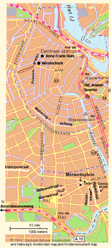
This map is a version of the map found on page 46 of Anne Frank: Beyond the Diary. With the help of a Hallwag map of Amsterdam, and the map in this Kindermonument tour. This compiled map has several locations and notes, a scale, and the correct location of the Anne Frank House (the AFBD got it slightly wrong, showing it where the Westerkerk is.) This is Amsterdam, a city of canals: blue is water, not streets. This map does not show all streets. In fact, there are streets along side of at least some of the canals. I got a couple of locations from this online map of Amsterdam, where you can also see more complete/extensively marked maps (but it is now gone). There is a new satellite image of the block of Amsterdam where the secret annexe was (their red + is not necessarily over the annexe even though the text describes the house).
First, some Dutch words can help:
dijk = embankment
gracht = canal
huis = house
kerk = church
plein = square
straat = street
toren = tower
weg = road, path
Centraal Station: during the occupation, Nazis often raided here to arrest and deport people (including Miep and Jan's landlady's daughter and her family). After the war, this is where Mr. Gies worked doing the paperwork for people returning from the camps.
The Anne Frank Huis is the Anne Frank museum, where Otto Frank's
business was during the war as well as the "back house" where they
hid (the secret annexe). The address is 263 Prinsengracht,
the web site is www.annefrank.nl.
Also, see notes about the immediate neighborhood.
According to Moon Metro: Amsterdam, the Anne Frank Huis takes less than an hour
to tour. It opens at 9 A.M. Related museums to try: for Amsterdam's history,
Amsterdams Historisch Museum
(at Kalverstraat 92 — is a circled AH on map);
to learn about the WWII Resistance efforts,
the Verzetsmuseum (at Plantage Kerklaan 61A
— is a circled V on map);
to visit the main point of departure for Dutch Jews deported during WWII,
the Hollandsche Schouwburg (at Plantage Middenlaan 24
— circled HS on map); and for the history
of Amsterdam's once-sizeable Jewish community,
the Joods Historisch Museum (at Jonas Daniel Meijerplein 2-4
— circled JH on map). Also, the city archives building, an elaborate 19th
century building includes rotating exhibits as well as the city archives:
Amsterdam Gemeentearchief,
at Amsteldijk 67, shown as a circled AG on the map.
Westerkerk, or Westertoren clock tower, is the church on the corner to the south.
Its bells rang every fifteen minutes, which took some getting used to for those
in hiding (Anne's 11 July 1942 diary entry; CE p. 216).
It is the tallest church tower in Amsterdam. On summer weekday middays, visitors can
climb the tower.
(There are aerial photos of the Anne Frank House area on page 532 of the Critical Edition, in the Frank House CD-ROM, in Miep Gies' book, and on page 49 of Anne Frank: Beyond the Diary.)
The Old Jewish Quarter is frequently mentioned in accounts of Amsterdam WWII history (but sometimes it seems to me they mean south Amsterdam, around where the Franks lived).
Weteringschans street is apparently where Weteringschans Prison was located (LSMAF, p. 174). The people in hiding were taken here after an overnight detention at the S.D. headquarters. They were kept here until August 8th, when they were sent to Westerbork. Mr. Kleiman and Mr. Kugler were kept in this prison during 7-11 Sept 1944, before being sent to labor service. (CE, p. 49-50)
37-II Merwedeplein is where the Franks lived (a third floor apartment — two floors above street level).
Around the corner to the south is where Anne first saw her diary. Here is a modern day photo of the shop, which still exists.
(There are photos of their apartment neighborhood on pages 22 and 43 of Anne Frank: Beyond the Diary, a photographic remembrance; pages 6 and 7 of the Critical Edition; and in this sizeable photo collection — Site down: 10 Sept 2003)
1 Victorieplein: just to the northeast of Merwedeplein, this square used to be called Daniel Willinkplein. Here, at #1, was Delphi a neighborhood tea room Anne mentions going to (along with Oase) early on in her diary before they went into hiding.
25 Hunzestraat: where Miep and Jan Gies lived in rented rooms on the ground floor during the war (AFR, p. 62-3).
1 Geleenstraat: Oasis (Oase), an ice cream shop and tearoom that the Franks liked to visit. It reportedly still exists. (CE, p. 185; see also Anne's original diary entries dated June 20th, June 30th, and July 8th, 1942; CE p. 185, 202, 206)
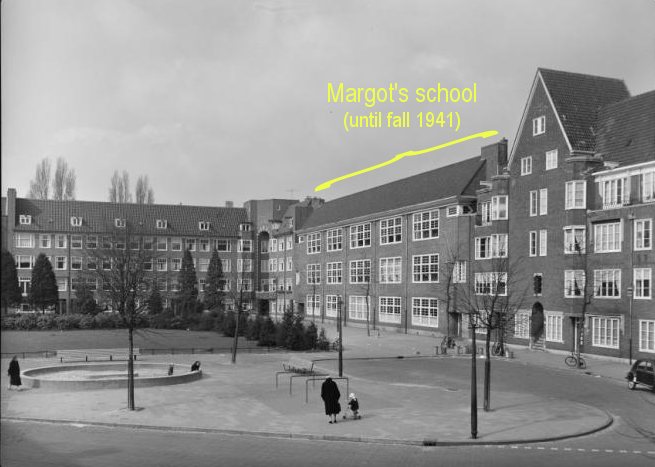
41 Niersstraat: Anne's school, the Sixth Public Montessori School, which is now named after her. It was a ten minute walk from home. (Margot rode her bike to attend a school on Jekerstraat — period photo.) Anne attended school here from May 1934 until 1941 when the anti-Jewish laws forbade it. Modern day photos are at this Kindermonument page. (Biography p. 53, 62, 131)
Rijnstraat:
#71-73: Koco, a Jewish-owned
ice cream parlor where an historic
confrontation took place between Jews and Nazis. This should be at about where
the "R" is in the map. Period photos are at this
Kindermonument page. (Biography, p. 122-3)
#238-3:
Before mid-1940, Jan Gies rented a room within this
apartment.
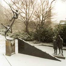
Gaaspstraat (north end of it):
8:
a memorial to Jewish children who died in the war. It is located where
a Jewish market had been.
photo,
winter photo
25-3: Miep and her foster family lived here,
across the street from the market.
25: In 1933, Mrs. Blitz-Roos lived in this
apartment, "several floors above" Miep's.
(AFR p. 14, 15, 24; Blitz-Roos is called "Mrs. Blik" in this book.
A researcher sent me her actual name and old address. I used to have 12-3 as her address:
the researcher explained that the house numbers were revised between 1933 and wartime.)
Near the Amstel river, and near the Frank's neighborhood, is Amstelrust, an old house which used to have a tea garden. The Frank's visited here at least once, in June 1938.
Euterpestraat is where the Nazis set up a lot of departments, including
the Amsterdam Headquarters of the S.D. (in former school buildings). These headquarters
are where the people in hiding, along with Mr. Kleiman and Mr. Kugler, were taken
on 4 Aug 1944, immediately after the raid. This is also where Miep tried (unsuccessfully) to arrange
a bribe to get her friends out (AFR, p. 202).
The street continues for a few blocks
west of the map. Shortly after the war, the Euterpestraat was renamed
Gerrit van der Veen Straat
(Gerrit van der Veen was a leading Resistance fighter). CE, p. 49.
modern-day photo
Amstelveenseweg Prison is where Mr. Kleiman and Mr. Kugler were taken on 4 Aug 1944,
after the group stopped at the S.D. headquarters. The prison appears to have been
on the large street named Amstelveenseweg (LSMAF, p. 51, 91), which is several blocks west of this
map.
They stayed for one month before being transferred
to Weteringschans Prison. (CE, p. 49)
Also:
Mrs. Stoppelman's details include her old addresses.
Cohen details is mostly their old addresses.
|
Relevant Street Name Changes since the War
|