46.46 miles, 3:23:40, maximum speed 30, elevation gain estimate 1800'. Hiked 9 miles, 2000'.
Up early for a cool clear day that warmed up as the sun rose. Could hear our host exhorting someone on religion – a preacher maybe? Never did meet him; Maxine could easily be imagined as a preacher’s wife. Lovely breakfast. Maxine went to a lot of trouble, more toward the home cooking side than the professional chef side. They’ve been B&Bing for five years. Did well until the two B&Bs opened in Chester. She said 6000 people attended the fourth of July parade in Chester last year.
I played with the front derailleur again, to no apparent avail. Seems to be a tradeoff between inability to quiet the ride and inability to reliably drop into granny. I wish I had a repair stand!
Turned off highway 36 onto A27, the Johnstonville road. Just after crossing a railroad track, I spotted the green of money! Made a quick stop, to Jacky’s mystification, jumped off the bike, and started scooping up dollar bills along the side of the road. There were also credit cards, even a social security card. A prescription for glasses. Very bad luck for someone. No wallet or purse.
Jacky joined me; we picked up everything we saw, stowed it in an empty pocket in a pannier. Thought we might pass a police station somewhere or wave down a patrol car. Rode on past Johnstonville prison. Doubtless there are police in there, but not the kind I want to meet.
By the time we got to highway 395 at Litchfield, the stiff south wind was well under way for the day. A big cloud of alkali dust was blooming up from the dry part of Honey lake.
Made really good time for the first 20 miles or so. Basin and range country, still descending slightly from Susanville. Isolated ranges everywhere, north-south orientation, road running along their valleys and over their shoulders when necessary. Long, long climbs, and long, long descents. Jacky measured 18 miles peak-to-peak on one valley. The climbs mostly didn’t require granny gears; the descents mostly didn’t allow coasting. We had a strong tailwind, made good time. Moderate traffic, good shoulder. No cops. Completely empty country. We had a full load of water bottles and food, and rightly. Strong south wind kept us cool riding east and helped when we turned north. However we got into rolling hills that cut our progress to 10 mph average.
We agreed that this tandem is not one we want to keep. We are surviving it, not enjoying it. The front fits me, though it’s difficult to manage, hard to control. I don’t know whether it’s possible to get a tandem that’s easier to control, given that I’m not six inches taller and fifty pounds heavier than Jacky. The back is too small for Jacky, and she’s sore and has numb hands. We’ll sell it, maybe try touring on separate bikes with me towing a trailer to equalize effort, maybe try some other tandems.
Passed a historical plaque on the Nobles-Emigrant trail. Is Nobles a man’s name? [Yes. William Nobles, a prospector from Minnesota, developed this trail in 1851 as an alternative to Lassen’s death route.] We encountered this trail again in Mt Lassen park.
Every time we told people we were spending the night at Ravendale, they would first express surprise that it was even possible, then sympathy. So we were psyched up for a pretty dismal night in a town whose size we estimated at one building.
As we left Susanville, we saw a billboard advertising Spanish Springs ranch, food and lodging. When we finally got to the ranch turnoff, a few miles short of Ravendale, Jacky suggested stopping, at least for lunch. The unpaved road disappeared up into the hills, with no sign of buildings anywhere, and it sure looked like a wild goose chase to me. I was not enthusiastic at all. But Jacky pointed out that we had nothing else to do today anyway, and we could at least get one real meal even if Ravendale was a complete loss.
So we tied up the bike at the rail fence (one without fenceposts), and walked in. The sign said one mile – of course, these are country miles we’re talking here. Grumble, gripe, growl! As we trudged up the hill in pursuit of our wild geese, cars kept passing us, some with horse trailers. Quite a few, actually.
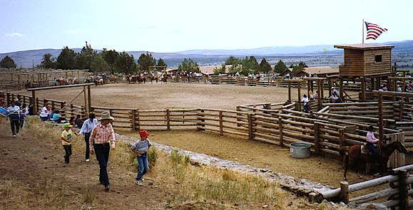
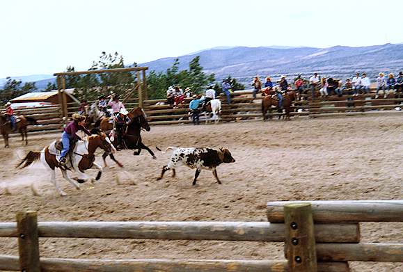
Well, turned out the place is a dude ranch, there was a junior rodeo today, and there was still one room available tonight, slightly permeated by reminders of a skunk in the crawl space. We assured them that we like skunk, and signed up.
While Jacky finished registering for the room, I called and arranged for a deputy sheriff to meet me in about an hour. Then I headed back down the hill for the bike. Actually managed to ride solo up the hill. It helps to have wide tires and a long wheelbase, and it hurts to have almost no weight on the rear wheel. Met Jacky a little below the top. It turned out that the previous occupants of our room had decided to stay – they must have liked skunk even more than we – so we got a no-extra-charge upgrade to a palatial cabin. A bedroom, living room, big kitchen, walk-in closets, etc. Couldn’t ask for better.
Jacky scrounged up some lunch while I waited for the sheriff’s deputy. He seemed a little surprised that anyone would actually turn in found money, but took the collection and gave me a receipt. Lodging, check. Lunch, check. Sheriff, check. Changed clothes, went out to see the sights. There was something of a rodeo going on; we watched for a few minutes.
Went off for a hike on one of the back-country riding trails. Naturally, we headed uphill, followed one of the trails to the north. The trail followed an open-wire telephone route – 8 pairs – for a ways, then went up past two small dams and dry ponds to a subterranean sometime river. Its bed was full of chunks of black porous lava, level with the surrounding terrain, but bordered with aspens. The river began at – presumably – a spring.
We kept hiking until the agreed turn-around time, slightly short of the crest, but high enough for a handsome view of Honey lake, several volcanic peaks and Mt Lassen over the ridges to our west. It was chilly in the wind as we started down. Glad we brought jackets.
Met an evening trail ride going up as we were going down. About 20 riders. Jacky thought one of them was a man she’d seen in a wheelchair at the rodeo. The rodeo was still in progress, with a much attenuated crowd. Showers, clean clothes, went looking for food.
The official food of the evening was barbecue from a pit just outside the dining room. We decided to order from the menu instead, and almost got ignored in the rush. Finally ended up with steak for Jacky, prime rib for me. Once in a long while! Couldn’t eat all the meat, but finished up the beans, potatoes, veggies and bread, and ordered dessert.
We started the day expecting a disastrous overnight – and ended up about as spoiled as it’s possible to be. We must be doing something right (turning in found money?)!
59.88 miles, 3:49:11, maximum speed 39, elevation gain estimate 700'.
Up early. Breakfasted in our room on stuff we had carried yesterday in case Ravendale was a no-op. Boboli, deviled ham, bananas. Altimeter completely dead now. I melted the battery caps by putting it over a light bulb. Have to get another when we get to a town with a bike shop. Very unsatisfactory.
Cool and clear. Startled a rabbit on our front steps when we went out. I rode the bike down the hill – lots of rabbits. Jacky walked down, accompanied by an ultra-scrawny dog. The dog came along with us, keeping up with the bike for about a quarter mile, then turning off into a collection of buildings that were probably employee quarters for the resort. On the road just after 8.
Rolled through Ravendale in a few miles. There was a real motel, with three or four cars in its parking lot – but no sign of a restaurant or grocery store. We did the right thing.
We rode the Madeline plains, high desert above 5000'. As yesterday, only a few grades required granny or allowed coasting. Cranked along at a goodly pace, typically 20 mph. Most of the day, the road had a wide shoulder, adequate to good surface, light to moderate traffic. No cops.
Stopped for coffee at Termo’s combined general store and gas station. Stopped again at restaurant in Madeline. Today was brunch Sunday, place was crowded. Brunch was a buffet of scrambled eggs, meat, hash browns, waffles, etc. We just had hot chocolate. Jacky went off to the washroom to shed her cold-weather tights. While she was gone, someone commented on the bicycle built for two, and I ended up anchoring about four distinct conversations at once, about bikes, grades, routes, etc. Friendly folks. They claimed we had one little bump to ride and then it was downhill all the way to Alturas.
It was actually several bumps, including a granny climb north from Madeline to Sage Hen summit. Along the climb, the country changes from open sage to sparse forest. There is a long descent all the way into Likely, with some really spectacular distant views. Warner mountains to the east and north. The forest ends halfway down.
Likely is in a green arroyo on the south fork of the Pit river. The green is very pleasant, but there’s not much there there. Waved to some teenaged girls as we rolled through. From Likely to Alturas is essentially flat with low rollers. Our stiff south wind disappeared around Sage Hen summit, and we seemed to be back in the west or northwest Pacific wind pattern. Slowed us down.
A dark blue pickup passed us and someone threw a full drink can at us. Didn’t hit us, but we both got some spray. Three guys in the truck, disappeared down the road. Three minutes later, a CHP vehicle came along, southbound. The first cops we’ve seen in two days. We waved them down, told them the story. They radioed Alturas police to watch for the vehicle. We weren’t optimistic, because we didn’t have a license number, and the CHP did not remember seeing a pickup. Big deal.
Ten minutes later, the CHP pulled up behind us. We stopped. They said the Alturas cops had stopped the guys and given them hell! So the system really does work sometimes.
Cops friendly, asked how often we got harassed. Chatted a minute. Between there and Alturas, perhaps ten miles, we passed them back and forth at least four times, watched them stop two cars. They were having a busy day.
Rolled into Alturas shortly after noon. Our longest day in miles, but also our fastest. A flat town with beautiful crisply detailed Warner mountains to the east. Only low hills to the west – surprised that we couldn’t see Mt Shasta. After careful inspection of the clouds on the horizon, we concluded that that cloud over there, the one with the pointy edges, was probably Shasta.
Had reservations at Best Western Trailside motel, saw it as we came into town. Ok, nothing special. People notice our bike – while I checked in, Jacky chatted up a couple from Vancouver who were admiring it.
Went out to see about lunch. Everything closed for Sunday, even the laundromat. Had a good pizza made to order – all veggies – at the non-smoking Pizza and Pasta restaurant. Wandered around town. Nice park. Tourist info stand, closed. Forest service, closed. Locomotive fenced in to prevent vandalism. Unusual architecture in the Modoc county courthouse. Library, closed. Strolling out to the north of town, we found a bike shop, Wheels. Officially closed, but someone was working inside.

Back to the motel for naps. Got a rag from the motelier, cleaned and lubed the bike. Figured out how the front derailleur was supposed to work, adjusted it. On a test ride around the block, I could use all 21 combinations, and it dropped into granny under load without protest. Maybe it will do better now.
Short Tour de France coverage on TV. Lemond advanced from 15th to 10th place overall. Back to Pizza and Pasta for pressions. Ate grocery store food in room.
37.16 miles, 2:45:32, elevation gain estimate 1500'. Hiked 1.5 miles, 300'.
Up early. Breakfast in our room. Then loafed until the laundromat opened at 8. Jacky did laundry while I walked the town. Picked up some bumpf from tourist info and forest service.
Two bike tourists from Seattle working on their bikes. I asked if they had tools and everything they needed. They had been on the road a week, heading for Tahoe. They planned to stay in Ravendale. I told them about groceries, motel, and Spanish Springs resort.
We took Centerville road – figured there would be less traffic and possibly more scenery. Right about the traffic, probably not much scenery on either route. The map calls it Warm Springs valley, but we saw no evidence of springs. Saw eagles, pistol and rifle club, what we thought was a housing development and later discovered was a resort. Saw a closed Mexican restaurant, the Alamo. Later, No Hunting signs posted by the hunt club, and three deer behind a tall fence. Road was pretty bad, wide transverse cracks. Especially hard on the stoker. Derailleur worked great.
Rolled into Canby a few minutes after 11. Canby was the general assassinated during truce talks in the Modoc wars.
All our fears of Ravendale came true here. Crummy old building, bar and restaurant downstairs, two rooms upstairs. Guy sent us up to pick whichever one we wanted. The rooms share a bath between them. On one side, the common door doesn’t lock; on the other side, the common door has had a peephole carved into it. Lousy plumbing, flies everywhere. The windows can be opened, but the upwind window is just above the exhaust fan from the kitchen. At least it’s cool.
Had peanut butter sandwiches on a picnic table at the ranger station two doors away. Stopped in to enquire about nearby hikes. Woman told us about Howards Gulch campground. There’s a new trail there, short but scenic.
So we took the unloaded bike out for a hike. Seven miles, up! By the time we got there, we wondered whether it was worth the trouble. The campground was just off the road. One campsite was claimed, but no one was around.
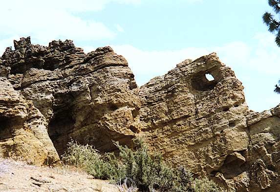
Well worth it! The campground and the trail were marvelous. Chipmunks, volcanic rock, a view of the highway, tracks, valley and mountains. We took the new trail about a mile and a half around a lot of Jeffrey pines (still sniffing the trees!) and some road-runner cartoon rock formations. Rocks look like a lava flow on top of sandstone strata, all of it thrust upward erratically.
Napped on a picnic table until the sun came out. A chipmunk bandit checked out the bike – he probably smelled the raisins in the rack pack. Sorry, friend, no hand-outs. Back to Canby. Stopped at ranger station to thank them. Turned out the woman we had talked to was a personnel clerk, not a ranger. Good for her! Helpful and knowledgeable.
To the hotel. Checked in formally. $17.50. At least we can’t complain about the price. Jacky tried the first shower, decided there was no hot water, made it a sponge bath. I let the water run longer and eventually got vaguely warm water straight from the hot spigot.
Grocery store for snacks. Read and wrote diaries on a picnic table by the store. Had to get our jackets as the wind came up. Looked over Lava Beds bumpf. We estimate 52 miles tomorrow without Lava Beds detour, about 71 miles with. I can see 600 vertical feet early on, with another 300 on the Lava Beds route. This is in addition to rolling that may not show on map, and it ignores the wind. A difficult day ahead, but unless we’re really in bad shape, we’ll probably do it. It would be a shame to be this close and not see the sights.
Wandered around town, found an amusement park (what, in Canby?). Closed, just a place to wander around and explore. Maximal use of old tires and cable drums, painted in gaudy colors, rides and stands for concessionaires. Amazing the things that turn up. A monument to somebody Abdullah, who died in 1989.
Read on the Forest Service lawn until the cold, darkness, and mosquitoes drove us inside. Back in our room, we had to swipe a light bulb from the other room before we had enough light to read by. Then to bed. Somehow we survived another one.
73.18 miles, 5:41, maximum speed 34, elevation gain estimate 1200'.
My idea that traffic would die down on the highway proved to be erroneous. Trucks went by – now and then – all night. Kept the window open, slept ok in intervals, but it wasn’t the best night’s sleep I ever had. The mattress consisted mostly of an underdamped field of springs.
Up early, peanut butter sandwiches in the room. Tried to fill water bottles, but the water smelled of oil, so we filled them from the hose at the ranger station. Goodbye Canby – and good grief! Clear and cold, fingers numb. Didn’t bother with a jacket because I knew we would be climbing immediately.
The climb out of Canby via Howard’s Gulch was the only long climb of the day. Actually seemed easier this morning than it did yesterday. There was only a mile or two of climb beyond the campground. Then we churned along at 15-25 mph. Back into open forest, lodgepole and Jeffrey pines. Saw four or five jackrabbits. Got our first look at Mt Shasta through the trees, round and white above the horizon, beautiful. The road had a good shoulder, good to fair surface. Stopped at the agricultural inspection station for water. Inspector said the shoulder ended at the turnoff to Lava Beds monument four miles ahead.
It was early, cool, easy going. We took the Lava Beds route. Light already, the traffic went to almost zero. The road was fair to poor as far as the monument entrance, then good.
Saw a sign at Tionesta for George’s Timber Mountain store. Stopped for coffee and sweets. Place was deserted. Turns out that George only charges for the sweets. There’s a kitty for coffee – put in what you think it’s worth – or take money out if you think it’s really awful. Waitress said the kitty hadn’t gone bust yet.
There was also a place (Eagle’s Nest RV park) whose sign advertised cabins “intermittently.” A real shame we didn’t know about them – staying here instead of Canby would have been a far better mileage split, and even if the accommodations were primitive, it would have been quiet, with scenic hiking right out the front door. Next time!
As we rode on toward the Lava Beds visitor center, the road climbed, first through gentle rollers, finally through a few hundred feet of granny grades around Caldwell and Crescent buttes.
Only a dozen people or so at the visitor center. The tandem was an immediate attraction, as always. Chatting with folks, got a strong recommendation for hiking and exploring in the Warner mountains. An excuse to come back someday.
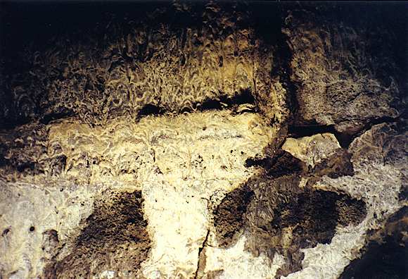
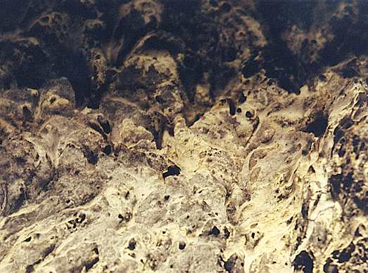
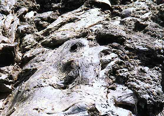
There are hundreds of caves in the monument. They are lava tubes, outer shells that cooled and froze around rivers of lava, which then receded. One of them, Mushpot cave, is at the visitor center. It is the only one with paved paths and electric lighting. These pictures show the way the molten rock froze on the ceiling.
Nice when we got back out in the daylight. Picnicked on the lawn from our hoard – rye crackers, Vienna sausages, raisins, almonds. Loafed a little before going on. Stopped many times on the way through the park. Schonchin butte is a cinder cone with trees on one side and nothing on the other, and a fire lookout at the top. Schonchin John was Captain Jack’s lieutenant (and Captain Jack was the Modocs’ leader during the Modoc wars).
Tied bike up at turnoff to Fleener chimneys and hiked in a mile to see them. These are the source of the Devil’s Homestead lava flow, which we passed a little further down the road.
Lava that flows like fudge is called pahoehoe, five syllables, obviously a Hawaiian word.
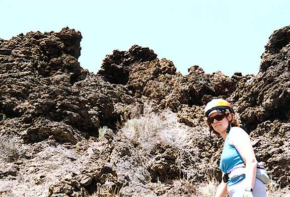
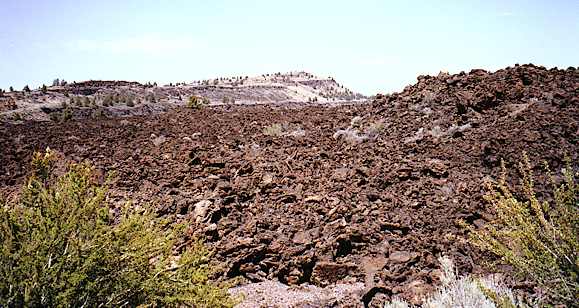
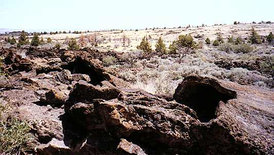
The Devil’s Homestead is a flow of “aa” lava (two syllables) that really does look like a river, a wide level expanse of broken rock. If the word devastation didn’t exist, it would have to be invented to describe this. Undisturbed terrain is visible in both the foreground and background of this picture. The edge of the flow is quite abrupt.
Still, sage grows here and there in the rock, frequently in continuous lines that I speculate are collapsed lava tubes that have accumulated more soil or water than the rest of the rock field. Sometimes the openings of the lava tubes are visible.
It also looks like something to describe with fractals. At any level of detail you examine, there’s more fine detail beneath it. I also realized there’s macroscopic detail above the obvious – the surface really isn’t even close to being flat – but the size of the irregularities is hard to perceive because there’s no perspective. Did I say I wanted to see obvious, visible evidence of vulcanism? Whew!
There is an immense view to the north and east. A sign said 150 miles on a clear day – easy to believe. Gillem’s bluff is a high, steep hillside with lava cliffs, many of them fractured in ways reminiscent of the Devil’s Postpile. The road runs at its base for several miles. Stopped briefly at Gillem’s camp, where the road turns east. Saw Canby’s cross from the camp, didn’t stop. We already know that story. Interesting, though: the sign talks about how the Modocs’ decision to assassinate Canby sealed their fate. One would think it sealed Canby’s fate, too! Stopped at Captain Jack’s stronghold, took the short loop trail. Full view of Mt Shasta from here, head in the clouds.
We were both hot, tired, bonking. Ate some raisins and almonds. Squirrel was sniffing around our panniers when we got back to the bike. Hung around while we ate, hoping for a handout, no luck.
West part of Tule Lake is dense grass, probably marshy. The whole valley is brilliant green. Display says most of old Tule Lake has been drained for farms. We’re still in the great basin. Where does Tule Lake drain to? It isn’t an alkali lake, so it probably does have a drain, but we can’t tell from map. [We were later told that a canal had been dug to drain it into the Klamath.]
The road runs along dike that forms the south edge of Tule Lake sump. The air was thick with insects – something like mayflies or caddis flies? Got covered with them – geared down so I could breathe with a mostly closed mouth – else I would have inhaled them by the dozen.
Tired and grumpy. Skipped the side trip to the petroglyphs and to Newell where the Japanese internment camp was. Turned north, headed for town. Prisoner’s rock interesting and impressive. Strange shapes.
Lots of birds along the drainage canal. White herons, several kinds of ducks. Seagulls, red-winged blackbirds, one big eagle. And many examples of a bird I couldn’t identify [ibis]: wading birds the size of a heron, black or dark brown, very thin neck and head, downwardly curved bill. Frequently these birds would void upon becoming airborne. Makes sense, I guess – reduces weight.
We had a reservation at Park motel, half a mile south of town, by happy coincidence. Old motel, cinder block construction, no other customers. Still, Tulelake was a big improvement from Canby, and very welcome after a great, but difficult, day. One of the local crops is horseradish. There is an annual horseradish festival in June.
After showers, we walked into town. Laundromat first, then we looked for a restaurant. Several bars, a hotel modeled on the one at Canby. Debated supermarket versus drive-in Mex. Then we noticed an umbrella over a table in the next block. No! Couldn’t be! But it was – a nice-looking place, Joanna’s Pizza and Pastry. They had breakfast too, open at 6. Someone told us that if you showed up at 5:30, Joanna would let you in. Good food, and the prices were incredible: a 10-inch pizza for $4.45. We had the $8.45 14-inch pizza with lots of veggies, and finished it! Good! Once we’re off the bike, cleaned up, sheltered and fed, we’re happy as clams!
Got a couple of ice cream bars for motel. That vanilla smell touches a very deep chord! Tonight the TV has stories about earthquakes at Mt Shasta. We can see Mt Shasta and even Shastina through a gap in Gillem’s bluff.
View Guestbook
Jacky’s home
Dave’s home
View old guestbook
Email: ![]()