Biked 3.44 miles, 23:18, maximum speed 33, elevation gain 0.
Walked to Safeway and bought rolls for breakfast. Back to the motel for the cantaloupe we’d had for a while. Ate in the motel room. In the first five minutes before I stopped counting, I saw half a dozen trucks with welding generators heading out for a day’s work on the pipeline. Loaded up the car, checked out, went down to see central Burney. Not as much of a no-op as we originally thought. Stopped at a store (open at 8, no less!) and got a few items of clothing to give us a little more flexibility in laundromat days.
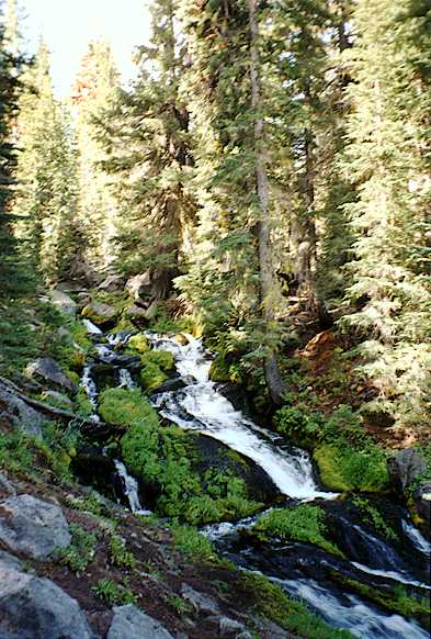
Drove to Fall River Mills. Hilly, some impressive road cuts. Open forest near highway 89, becoming treeless further east. No shoulder on road. Penstocks coming down a steep hillside, presumably to a generating station.
Fall river is not very impressive, though there is a vista that displays it to its best advantage. Old disused bridge across Pit river, away down in the valley; its access road is almost obliterated by years of landslides.
Fall River Mills also not very impressive. The only recommendation at the forestry station was the Pacific Crest Trail. Stopped at the Fort Crook museum for a minute, closed. From outdoors, it would appear that the museum focusses on Fort Crook, ten miles north of here.
We had the idea of hiking some part of the Pacific Crest Trail. The trailhead at highway 299 was not very inviting – looked hot and exposed. We debated going back to the McArthur-Burney Falls state park trailhead, but decided to go on to Old Station instead.
There has just been a fire at Hat Creek. The USFS work center was set up as a fire camp. Stopped in for a minute to see about maps and trails, but they clearly had other things on their minds, so we went on. A little further south, we passed the point where the fire had burned along the road, a few hundred feet, still smoking. The fire was out and the fire camp was disbanding.
Came on into Old Station. Mt Lassen B&B looks nice, and has its own meal service for guests. But we’re at the Rim Rock ranch, a collection of aged cabins, in a room above the garage. Adequate. $27.50. Can’t complain. We unpacked everything but the bicycle and helmets.
Lunch turned out to be Hobson’s choice. Uncle Runt’s, one of the town’s two restaurants, is closed on Monday, the other, Brangus Burgers, is closed on Tuesday. Grilled cheese for me, burger for Jacky. We agreed that we had satisfied our grease quota for a month.
Drove out to Subway cave. This is a lava tube without lighting or a paved path. You supply your own flashlight and jacket. A bit of an anticlimax after Mushpot cave at the Lava beds.
Then we drove out highway 44 in search of PCT trailhead. 44 climbs the Hat Creek escarpment in one long grade. This is a thousand-foot vertical displacement along an ancient fault line.
Stopped for a map check. Funny noise when I started the engine, and the brake warning light wouldn’t go out. Drove to PCT turnoff and half a mile down a good but unpaved access road to the trailhead. Car acting funny. I shut it off, tried starting it again – it wouldn’t crank. Tried pushing it. Let it roll down into a little dip, but couldn’t get it to start. Oh-oh! No hiking today.
Glad we had the tandem up top. We had our helmets, bikie gloves and my cycling shoes. Jacky rolled up her pant legs and loosened the toe clips so she could ride in running shoes. We rode the bike down to summon help. No sooner did we start the long descent down the escarpment than the bike went unstable. Stopped and pumped up front tire hard, to check another theory I had developed. No difference.
No shoulder, quite a bit of traffic. A loaded logging truck waited behind us till we got a place to move over – thank you, mister! I balanced the speed somewhere between my concern about traffic and my concern about the bike.
Phone booth at edge of town. Called AAA Burney, Ken’s towing service. Ken was out but called back ten minutes later, about 3:20. Said he’d be over in 40 minutes.
Jacky took the bike back to motel, returned with overnight essentials in case we ended up spending the night in Burney. Two hours passed – no tow truck. Finally called and told them we would be back at motel. Packed everything up, so we would at least have all our stuff, whatever might befall. Figured we’d have to spend the night in Burney, because all the garages would be closed by the time we finally got there; we’d have to leave the bike here until we got the car running again.
Ken finally showed up. Had to stop and chat with motel people, of course – if you’re in a hurry… There was room for the bike crosswise behind the cab, so we had everything with us. Told motel people we might or might not be back, left the key.
Ken started troubleshooting at the beginning. Step 1 was to jump our battery. Step 2 was to check the starter solenoid – lo and behold, the wire had come off, doubtless a testimony to unpaved roads. A quick fix, once you know what to fix. The complexity of the symptoms had thrown me off the track of even thinking about simple problems – but I should certainly have known about sneak paths in electrical circuits. An education.
Gave Ken a $20 tip, thanked him profusely, went back to Old Station to reclaim our room. Ken drove back too, to finish his chat with the proprietors.
Too late for more adventures. Showered, went out looking for food. Got stuff at the country store for an early breakfast. Decided to go back to the Brangus bar and grill for a Hobson’s choice steak. Evening meals were served in the bar; the restaurant section was closed.
Good decision. Not only was the food better than expected, but we collected some anecdotes as well.
Asked waitress about pipeline. She referred the question to a fellow sitting at the bar, who had his own collection of anecdotes.
As we left the bar and grill, the full moon was rising.
Hiked 15 miles, 8 hours, elevation gain estimate 4000'.
Up early. Had peanut butter sandwiches in our room and headed out. The starter wouldn’t crank. Took about five minutes to re-connect the wire. I can see why Ken didn’t get it on squarely: it’s blind. If this keeps up, we’ll get really good at it after a while.
Jacky was in a regrettably frivolous mood this morning, though she pointed out that there was no one to regret it. Stopped for coffee at Hat Creek resort (south of Old Station: in fact the Old Station post office is there). Looks okay; on some future bicycle tour, this would be the closest place to stay north of Lassen park. We could have eaten pizza there last night, but I think Brangus was a better choice.
Commercial vehicles are not allowed through Lassen park. Nice to be free of logging trucks for a while. 35 speed limit and moderate traffic – would make a fine cycling route for people willing to climb hills. Us, for example. Entrance station not open yet (7:45), nor the visitor center.
We consulted the map, decided to park at Hat lake, hike past Terrace lake back to the road, take the road to the summit trail and ascend the summit. We started hiking about 8:30, estimated we’d reach the top between 12:30 and 1:00. Figured this would give us the best weather conditions at the top – late enough for morning clouds to burn off, early enough that thunderstorms wouldn’t be brewing up yet. Took both hiking water bottles, dressed warmly. Lots of cookies, raisins, granny bars.
The trail at Hat lake starts around 6500', where it intersects the Nobles-Emigrant trail, climbs along west fork of our old friend Hat Creek for a mile and a half. Cool, open woods, pleasant and quiet. A deer standing along the trail, watching us. Steady ascent for three miles until we got to the road. The road is another two miles of ascent. Gentler grade, easier on lungs, but harder on feet.
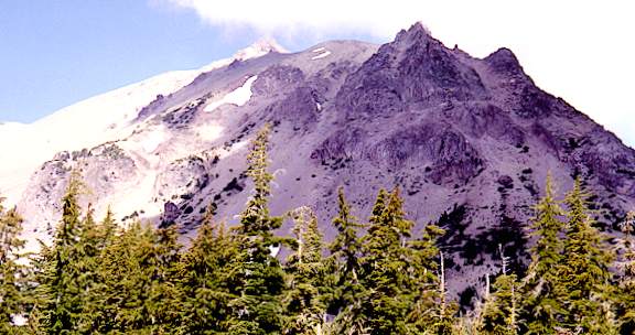
The Lassen peak trailhead is a little past the road summit, at 8460'. It takes 2.5 miles to climb to 10457'. The sign in the parking lot says the maximum grade is (a mere) 15% – what it doesn’t say is that, when you work out the numbers, the average grade is also 15%. At least you know what you’re in for, right from the beginning.
The trail from Hat lake was deserted, cool and shady. The trail to Lassen peak was open, sand, gravel, stone – and busy. We had food, water, and cold weather clothing – lots of folks just did it as a casual jaunt from their cars. They would have been in real trouble if a thunderstorm had brewed up. But it didn’t, not today. You’d never know the whole park had been closed by snow only two weeks ago. We saw little patches of snow above 8000', but the only good-sized snow field was right at the top.
It was hot enough hiking uphill, but not unbearable, and it was pleasantly cool at higher elevations, especially when clouds blew over, the breeze came up, or we stopped climbing.
Established a slow, steady pace that allowed us to keep moving. This turned out to be about the same average pace as another group – a woman wearing a black skullcap, girl of 10, boy of 8. What first attracted our attention was that both females were wearing dresses. The kids, full of energy, would rush ahead, then have to stop and wait for mom, who would walk too fast trying to keep up, then have to stop to catch her breath. We passed them back and forth several times.
The trail makes its way over to a fairly sharp ridge, then ascends the ridge via a semi-infinite series of short switchbacks. There are volcanic outcroppings here and there, but most of the route is loose stuff, dust or sand – ash, I suppose. There are bands of distinctly bluish rock running across the ridge, other bands of red rock, and black. Interesting geology.
Above 9000' the other trees give out and the white bark pine takes over. I initially thought they might be bristlecones, till I read the brochure – they are very similar, but not quite as gnarly as the ones on the White mountains. Even so, there are enough differences that I wasn’t surprised to learn they are a different species. About 10000' they become bushes instead of trees, then give up, and the rest of the climb is barren except for lichens and a few tiny plants here and there. Didn’t see or hear any of the pikas or marmots common to such country. Maybe they stay away from the trail.
As we climbed higher, the crowds thinned out. We met people heading down; it was interesting to see how happy they looked, now that their climb was over. We lost sight of our friends, figured they had given up and turned back.
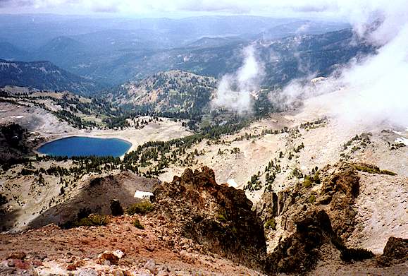
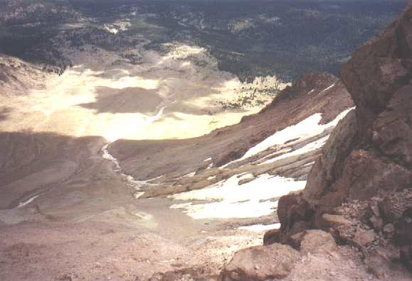
The following picture looks down the trail at Lake Helen, which as I understand it, is the most recent lava-emitting orifice of primordial Mt Tehama, of which Mt Lassen is but a puny remainder. Notice the band of red in the foreground.
Finally got to summit outcropping, only to learn it was a false summit. Had to cross a shallow dip full of snow, then scramble up a rockpile to reach the top. Clouds alternating with sun. When it’s warm, it’s actually very enjoyable to have clouds blowing past, alternately revealing and obscuring landscape near and far.
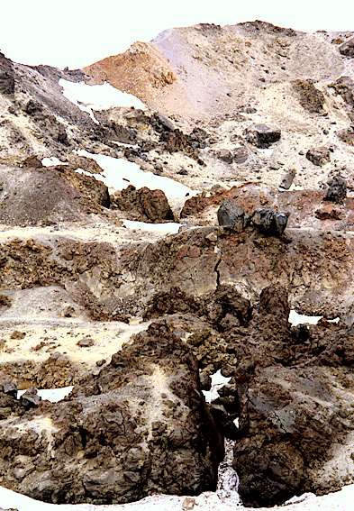
Here’s the summit crater area. Steam is said to issue from some of the cracks, but we didn’t see any.
Signed the register. There were six or eight notebook sheets full of names, and the oldest entry was dated July 11. A popular place.
Here’s the devastated area, where the mudflow of 1915 destroyed everything in its path. 75 years later, the lower reaches are slowly being reclaimed by the forest. Hat lake, where we started this hike, is at the south (right) edge of the devastated area, not really visible in this picture.
As we started down, who should appear at the top but our friends, who hadn’t given up after all! Talked to the mother for a minute. It turned out that her father had hiked the peak trail many years ago. Told her it wasn’t a bad hike at all, 45 minutes or so. Would you believe two hours? She said he was retired, 77 now, and had just moved back to the area. I suggested that she should challenge him to demonstrate the simple 45 minute hike himself one of these days.
Let’s omit the hike back. Suffice to say that we made it. We had no enthusiasm for further sightseeing today. Just drove out and headed for our motel. Still, one can’t help noticing how lovely the road is through the forest. And there’s Bumpass Hell, whose name fascinates, and Cold Boiling lake. We drove past the Sulphur Works, where great malodorous clouds of steam emanate from the ground. There’s Diamond peak, with unlikely rock forms straight from a road runner cartoon, and Brokeoff mountain, which looks as if its side blew out (it didn’t). We’ll be back someday – there’s lots more to see!
The Lassen Mineral Lodge is a collection of old cabins, gift shop, bar, café and country store conjoined at roof level. Cabin ok, price ok. Restaurant had lasagna, pie à la mode, and Sierra Nevada porter. Good. But oil lamps are a mistake. My food tasted like kerosene. We extinguished the one on our table.
Called Portola for B&B reservation tomorrow. We’ll try a physically sedate day.
Up early, a few calories in our room, headed for Chester. Breakfast at the Kopper Kettle, where we ate July 3. Smart enough not to order full size breakfast this time. Frivolity again this morning. Regrettable.
Waved to a couple with a loaded touring tandem at the grocery store in Greenville. On to Quincy where we stopped for coffee and a cantaloupe – helps assuage the feeling of inadequate fruit and veggie intake.
All these towns have murals. Artistic quality varies, but they tend to be pretty good. A good way to add beauty and interest to small and sometimes rundown little towns.
Saw a lone cycle tourist working his way up a grade – standing out of the saddle. Hard way to do it. Too bad it’s an exception to see cycle tourists. On the other hand, I developed the distinct impression as we drove back along these roads that it would be a heroic effort to go bicycle touring here – and we’re cyclists ourselves! I begin to understand how the ordinary joe considers this kind of thing completely inconceivable.
Portola is hot and open. There is a strip along highway 70, a bridge over the Feather river and railroad tracks (sign says No fishing or jumping from bridge). The old town is away from the road. Unfortunately, neither side seems to have the critical mass to survive and be interesting.
Found the B&B. No one home – they told me they would be at the groundbreaking for the new library this morning. Left the car, wandered around. Ended up at the railroad museum.
All Diesel, no steam; we were told later that they planned to acquire some steam, mostly to satisfy those who don’t believe it’s real railroad if it doesn’t have steam. Quite a few hobbyists working on restorations – looks as if they have an inexhaustible source of raw material for restoration.
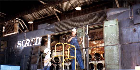
Some interesting cars: a troop sleeper car with 30 bunks, from WW II; a business car – a lounge with armchairs, antique Emerson TV, microphone with push-to-talk for radio communication to the outside world. Outside, a covered platform with a railing: the image of Harry Truman making speeches at whistle stops was irresistible.
Stopped at junk store to look for books to while away the time. Kid, six or eight years old, came in to tell us about his busy summer working there and riding his bike. Wearing a little blue apron. Lived in Manteca, he was visiting his grandmother for two weeks; she let him help out in the store. Great kid, reminded me of Matthew on our 89 cross-country tour.
Loafed, read, wandered around. Still no one home at the B&B. When I phoned for reservations, they told me which room we would have, and the door was wide open. So we moved ourselves in. Met the hostess, Lynne, when she got home. Jon was our host; we met him later. He said the Dutch in his ancestry influenced the spelling of his name.
Then off to the real old-fashioned drugstore soda fountain. About this time (in retrospect) Jacky lost her wad of bills, about $70. Called the next day, but neither the B&B nor the drugstore had found the money.
Checked bird book at (old) library – convinced that Tule Lake birds were indeed ibis and that the gray, black and white birds we’ve seen in the last couple of days are Clark’s nutcrackers. Lots of talk at the library about their new building. They hope to be able to move in in November; they are busy collecting donations, twisting arms, holding fund-raisers. Our B&B hosts are helping fill out applications for corporate grants.
Asked about Flatlanders, a restaurant with an Ecotopian menu. Lynne said she had seen their kitchen and didn’t eat there. Went to Log Cabin instead, alleged to be a German restaurant. Indeed, Jacky ordered Jägerschnitzel and Spätzle, but most of the menu was standard GOB. I got both noodles and baked potato by asking, and the salad included raw cauliflower. And they had Beck’s Dark. Not bad.
There is a beaver lodge in the Feather river, visible from the bridge. Our hosts said dusk is a good time to see the beavers, but we didn’t.
Woman watering her yard – puddle on the path. She was very apologetic as we came along – not for the inconvenience of the wet path, but for wasting the water that had gone into the puddle. Jon said watering is restricted between 10 AM and 5 PM, and people are asked to conserve. But existing construction doesn’t have water meters (new construction will), and one bloody-minded household can waste as much water as ten conscientious people can conserve. Obviously a controversial topic.
B&B has a tree book, but it’s not the western edition: no entries for lodgepole, Jeffrey, ponderosa, white bark or bristlecone pines. Not much help. Talked about tree-sniffing; Lynne said:
It’s okay to sniff the trees,
as long as you do it high up!
My sentiments exactly! (This regrettable frivolity is even infecting our hosts, now!)
Along with their efforts on the new library, Jon and Lynne have the chamber of commerce telephone at their home. Puzzles, a popcorn machine. Lynne was just freezing two hundred dozen cookies she had baked for the rest stops on the August 1 Portola-Sierra century they were sponsoring. They encouraged us to come back and ride it… not this year, I think.
Hiked 2 miles, flat.
We were up early, but we had acceded to our hosts’ suggestion of breakfast at 8:30. Foolish us: everyone else had asked for earlier breakfast; they all ate and left while we stood around chatting and waiting. Jon knows a lot about railroads, as might be expected. There was a crowd coming for the weekend to go on a train ride; the B&B was booked up. Good conversation, good breakfast when we finally got it. Great selection of raw fruit, french toast, sausages. But next time, we’ll at least express our preferences for an early start.
Mid-morning and already hot by the time we got out of there. Took Beckwourth-Calpine road A23 to Sattley. It runs along the western edge of Sierra valley, another big flat patch completely surrounded by mountains. Got gas at Sattley (or was that Sierraville?) – 40 mpg on this last tank.
Highway 89 south from Sierraville is an old narrow road with a bad surface and lots of logging trucks. Would be no fun on a bike. The road only improves a few miles from Truckee.
Stopped at ranger station outside Truckee, got some trails and natural history info. Town is confusing – drove around a while, more or less lost, as usual. Stopped to phone Best Western Truckee Tahoe Inn, which is southeast of town on 267. We were west of town on Donner Pass road at the time, so we went on out to Donner state park.
Strolled along lakeshore trail enjoying the woods and the lake. These woods are white pine, I think, much duller color than the red of the Jeffreys and ponderosas we have been seeing. Saw several western tanagers, very colorful yellow birds, and an amazing number of little juncos. These are birds the size of chickadees that like the forest floor and would be invisible if they didn’t move.
Picnicked on lawn at museum. There was a separate admission charge for the museum, so we skipped it.
Downtown Truckee to wander around. Lots of stores have signs restricting parking to customers only – pretty tacky, but maybe necessary in a tourist trap town, which this clearly is. Still, worth a visit. Quaint old buildings, lots of B&Bs, Ecotopian restaurants, even the first Mexican restaurant we’ve seen in a while. Old jail fixed up as a museum (closed). Historic red light district next door to the jail. Wandered in and out of a bike shop or two just to feel homey.
Showers, naps at the motel. TV story about Perot’s withdrawal from the presidential race. Thunderstorms brewing up – drove back to town rather than walking. Got a topo map of Donner summit area. Very helpful woman at outdoors store located in old blacksmith shop – penciled in Pacific Crest Trail on the map, since PCT was created after map was made. Stopped at Bar of America for brews, ate at Casa Baezo, a non-smoking Mexican restaurant. Hot salsa, good food, Negra Modelo.
Hiked 11 miles, 4 hours, elevation gain estimate 1300'.
Up early. Motel offered cereal, juice, breads starting at 6. Out a little after 7. Left car at Lake Mary off Donner Pass road. Picked up Pacific Crest trailhead at 7:45. We’ve been thwarted the last few times we’ve tried to hike the PCT. Perhaps the gods will smile upon today’s effort. Responsibility for smiling would presumably rest with the great god Nike? Oh, dear, more regrettable frivolity.
Cool clear morning. Beautiful country, starting with Lake Mary, a mirror surface when the wind dies down. Snowsheds along railroad are long timber tunnels just big enough to pass a train. Lots of variety – dense forest to desolate gravel and everything in between. Rock from granodiorite to glacial moraine – well rounded volcanic boulders – to hard conglomerate that defines many of the cliffs and outcroppings.
Wildflowers everywhere. Saw a couple of hummingbirds, a graceful hawk, and several little hoppy toads.
The trail climbs out over Sugar Bowl ski valley, but the bowl is only sporadically visible. The views of Boreal ridge and Summit valley are much better. The trail near Roller pass runs along just above conglomerate cliffs. Hiked past Donner peak, Mt Judah, Mt Lincoln, down toward Anderson peak. After looking at 20% grade on Roller pass, we figured that a scout who recommended such a route would probably have been fired – from a cannon. (A regrettable thought!) Fortunately, the steep part was only a hundred vertical feet or so. Ran out of time and turned back at 8000', about a mile from Anderson peak. Met a northbound backpacker on our way in, and a dozen or so day hikers on our way out. Nice to be earlier than the crowd.
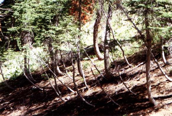
On slopes, the trees all start out bent downhill, then right themselves. Don’t know why. My best theory contemplates the pressure of snow, maybe creeping avalanches. Although the picture shows small trees, even the big ones have this characteristic shape. Clearly a continuing phenomenon.
Soda Springs for lunch. Good veggie mini-pizza at the Summit Pizza Factory. Took I-80 and California 20 to Grass Valley. Looked as if there were quiet side road alternatives to most of I-80, probably better road surface as well. Quite a climb out of Bear river valley at the top of highway 20. Passed two cyclists near the crest. Highway 20 is mostly a pretty good route.
Grass Valley has an old downtown, pretty interesting, seems lively. No significant number of vacant buildings. Sarsaparilla at deli, library, bookstores. Got Audobon guides for wildflowers, birds, rocks. When I get trees and insects as well, I’ll really be dangerous.
Went to park for nap. Park was at Brighton and Cornwall streets – there’s a monument nearby to 1850 discovery of gold-bearing quartz and spawning of hard-rock mining in California. Read somewhere that half the gold ever taken from California came from Nevada county. Two places downtown offering pasties, a delicious smell. Cornish miners, anyone?
On the other hand, the area at Church and Chapel streets is devoted to the Catholic church. Big old graveyard – most graves pre-date 1900. As well as optional items such as verse, the name of the spouse who paid for the stone, or in one case the name of the masons who carved the stone, the gravestones include three mandatory pieces of information: name, dates, and where in Ireland the decedent came from. True, not everyone was Irish: there was one from England, one from Canada, even one from Illinois. But easily 90% were Irish immigrants. Makes sense, I guess, for the Catholic cemetery.
Anna fixed up a great Thai meal and we sat on balcony and watched the sun set. Their view from Alta hill over Deer creek and Yuba valleys looks off to the northwest – Mike says there are visible identifiable features 170 miles away in the coastal mountains. Deer came out to munch on the garden, thwarted because Mike and Anna didn’t plant one, but it was too dark to see more than shadows. Mike and Anna have seen fawns in season, bears, even a fox with two kits checking out the motorcycle in their driveway.
Hiked 7.2 miles, 3 hours, elevation gain 1600'.
Up about 6:30, updated the diary on the back deck while enjoying the sunrise. Anna fixed pancakes full of pecans and apple shreds, and we topped them with peach fragments and blueberries. Mike showed us the route he would take to Feather Falls if he were going.
So we tried his route. Up 49 to the middle fork of the Yuba, west on Moonshine road, a truly abominable surface. Mike had actually described it as unpaved, and but for the absence of dust, it might as well have been. Marysville, Oregon Hill, La Porte, Challenge cutoff, and Forbestown roads are a medley of everything from abominable to excellent roads, but all are very scenic drives through the forests. Lumpkin road starts out great and turns into ten miles of grades that we mostly did in second gear and sometimes in first. The Civic was very unhappy with the climb, lots of valve clatter. We’ve been unable to buy high-octane gasoline for it, and it matters when we ask it for torque.
By the time we got to the Feather falls turnoff, it would have been easy to convince us that it wasn’t worth it. Hot, dry foothills forest. Poison oak everywhere at this elevation (1500 – 2500').
We were here many years ago. Since then, the first mile and a half of the old trail has been turned into a good unpaved access road. The trail is now 3.6 miles long, and my memory of a flat and easy hike clearly pertains to the part that has been replaced by the access road. Today’s trail is all hill, either up or down. It crosses one creek and several low places that probably become little creeks in winter.
Nice to be out of the car and onto the trail, even if it is hot and vertical. Lots of lizards, two banana slugs. Bay laurels creating a pleasant-smelling little nook along the trail.
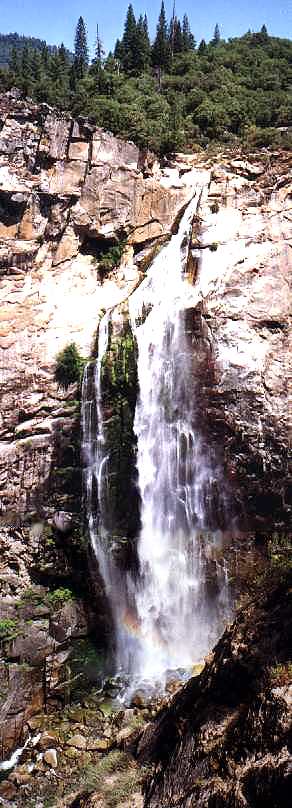
The heat and the hike are worth it. There’s an observation platform built out into the gorge, level with the top of the falls; across the gorge is Bald Dome. There was a lot of water in the river, and it’s a long way down. This is the sixth highest fall in the continental US. Despite what Jacky says, she doesn’t really get down on all fours and peer through the railing when she’s in high places.
Enough! Home, James. Got in about 7:00, and glad to be here. Walked to Whole Foods for a few groceries – a cool evening, green in all directions – a nice place to come back to.
View Guestbook
Jacky’s home
Dave’s home
View old guestbook
Email: ![]()