30.8 miles + 6 miles hiking, elevation gain estimated 2800 + 200'.
Carlo’s night chef fixed breakfast yesterday, but today was his day off, and Carlo did the cooking. Carlo really should stick to management and let his chef do the cooking. Still, a good guy. We enjoyed staying here and chatting with him.
Cool and partly cloudy when we set out. Steady climb to Bassetts. We made a bet on a sign that was too far away for either of us to read. I bet the sign said No fishing from bridge, and Jacky bet it said something else. It turned out that I was right about one of the signs; there was a second sign with river information. So we both won – we each owed the other a chocolate chip cookie.
Went up Gold Lake road, a total of 6700 – 4187 = 2513'. Altimeter still on the fritz. Stopped at Snag lake and Gold lake. Country looks a lot like Yosemite, exposed granodiorite, unusual in northern California.
Cold and windy at the top. Didn’t stay long. Bundled up for the descent. All the work we put into the climb was wasted: we didn’t even get a fast descent, because of newly graveled road. Set the drum brake as a retard, and made it down without setting a pannier on fire!
Highway 89 in Graeagle is narrow with no shoulder. Glad we didn’t come this way all the way from 49. The area is nirvana for golfers – courses everywhere. Graeagle was a strange spread-out town, open forest with houses built amongst the trees. Meadows, mountains in all directions. Stopped for a mediocre lunch at a good-ole-boy restaurant.
Interesting names: the town is Graeagle, but there is a Gray Eagle creek and lodge; a week later, we passed the body of water called Tule Lake on our way to the town of Tulelake.
The road got much better after we joined highway 70. Stopped at the ranger station for a Plumas forest map (we realized somewhere along in here that Plumas is Spanish for Feather, as in Feather river). Too bad the scale is so small and elevations aren’t shown, but at least it shows trails, fire roads, public vs private property.
Rode on over gentle rollers to Cromberg. The Long Valley resort is a cluster of housekeeping cabins. We got a two-bedroom cabin, the last one vacant, for $55. Turned out to be best cabin accommodation of the trip – kitchen facilities were clean, complete and modern. Very pleasant woman running it, too. Opal reminded Jacky of everybody’s mom. Lying down for a bit. Doctors don’t know what’s wrong. Maybe it’s what killed the neighbor man? She told us about a hike along the river.
After a short nap, we went out to try the little hike, down old Cromberg road to a cemetery. Two deer tentatively crossing the road, ran off into the woods when they saw us. Never did get right down to the river. Road eventually became paved again, went past a Sierra Pacific mill – no logs, shut down – and through the sparse cluster of houses called Sloat before rejoining highway 70/89. Lots of property for sale. Sniffed a pine tree. No scent – does that mean it’s lodgepole?
Ate in cabin from the grocery store across the road, even though it had limited selection. Got a Sacramento Bee to read about earthquakes. Put altimeter over the bathroom light to heat it up again. Will one more temperature cycle resuscitate it?
41.27 miles, 3:11:20, maximum speed 37, elevation gain estimate 800'. Hiking: 6 miles, estimated 500' gain.
Happy Dominion day! I did the “cooking.” OJ, banana bread, coffee, milk and half a banana each. Gave key to the landlady, who would have liked to talk for an hour or two. Escaped into a crisp, clear morning and headed north. The road rolls some, and crosses Lee summit, but the trend is down. Highway 70 eventually goes to Oroville. Not today, not us, thank you.
Stopped when we rolled into Quincy. Town appeared to be a dead loss. Five lanes of main street, strip development. Found a laundromat. Chocolate chip cookies to pay off gambling debts. Headed out.
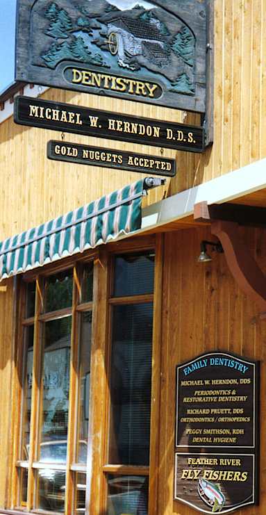
Then we discovered there are two Quincys! The real Quincy is about three miles further west. From viewing it as a total nothing, we changed our opinion completely – a nice little town. I was reminded of San Anselmo in Marin county. Tied up the bike on the courthouse lawn, explored a really nice old museum and strolled the streets. The dentist strikes me as a good guy!
Several references to Crescent Mills spell it Cresent. Sheesh!
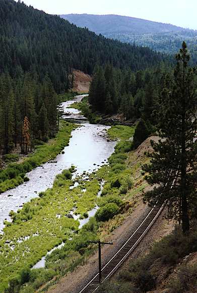
Headed out. Stopped at the crest overlooking Spanish creek, where the railroad emerges from one tunnel, only to enter another. A second (or maybe the same?) track winds by high on the hillside and crosses a trestle.
This is the first day I can breathe without pain. Starting to feel good, instead of just okay.
Saw an eagle being attacked by red-wing blackbirds at Crescent Mills. Every once in a while he would rear his wings, but mostly he just ignored them.
Not much further north, the walls open up and a nice sized valley appears (Indian valley). Greenville is near the northwest corner. Rode into town, where we decided to skip Digger Moore’s Sierra Lodge. Old ratty building in the heart of the town. Most unforgivable of all, one of their three signs was spelt Siera! A neglected downtown second floor hotel above a bar.
Back down the road to the Oak Grove motel, got another housekeeping cabin. Nothing like as nice as the one at Cromberg, but another opportunity to do our own cooking.
Decided to go for a little hike. Stopped at grocery store for small Bobolis to make up for no lunch. Short-cut a stream and tracks, and headed out, with the idea of walking the three miles to Round lake. Round lake is 900' higher than Greenville, on a grade that starts off at something like 10%. The lack of a real lunch (only a granny bar) got to Jacky along with the heat, so we gave it up before getting to the lake. Hideaway resort on the Hideaway road to Round lake looks like a better place to stay. Next time.
I never noticed before, but rail fences, those of the zig-zag persuasion, don’t need fence posts.
Still sniffing trees. Jacky, who first thought the scent wasn’t at all like vanilla, now developed a craving for some vanilla-flavored dessert. Stopped at grocery store for meal fixin’s, got a small peach pie (yes, yes, I know, but the appeal of peach overwhelmed the vanilla impulse).
The rain at Sierra City was snow on Lassen, enough to close the road. The road was only reopened today. TV news showed cars going slowly through snow-covered countryside. Maybe it’s just as well we’re not going that way. Worked on routes. Decided to go to Mt Shasta via Alturas and Tulelake, then back fairly quickly through the central valley. Booked two weekend nights in Mt Shasta city.
27.51 miles, 2:27:08, maximum speed 27, elevation gain estimate 1200'.
Awoke to the sound of a woodpecker and logging trucks. A sunny cool day. Ate in our room and headed out. There was a road sign as we left Greenville, something like:
Greenville mill closed
by US government
and spotted owl.
We had also seen signs in windows: We support logging!
The climb to Canyon Dam was pleasant, much of it not requiring granny gears. We could hear a train climbing out of Indian valley for a long time. He got to the top at the same time as we: three locomotives. Once at the top, he pulled away quickly. Looks as if the dam here is what defines the lake, keeps it from being just another part of the Feather river.
The road from Canyon Dam clockwise around Lake Almanor to Chester has a wide shoulder and rolls very gently. Half-step gearing is perfect here. A perfect, cool, sunny, beautiful forest and lake. A ride around the lake would be a great moderate sport ride. This is the way it’s supposed to be!
Stopped at a rest stop/campground for granny bars. Sign says PG&E generates 720 MW of hydroelectricity on the north Feather watershed. A lot of power! Map shows tunnels and penstocks from Lake Almanor to Butt Valley reservoir to Belden forebay to Rock Creek reservoir to…
From a map check, we noticed that our road aimed directly at Mt Lassen. Sure enough, it eventually popped into view. Lots of snow – don’t think we even really want to go there just now. By the shape, it’s easy to believe it’s a volcano.
Met a southbound touring tandem, and a few miles later, two solo bike tourists. More traffic on highway 36, but still a bike shoulder – it’s even posted as a bike route. Lots of cyclists in Chester, but an appallingly high percentage, maybe 70%, riding on the left! It boggles the mind!
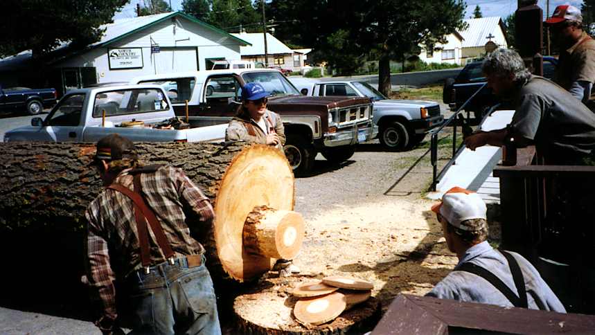
Got to Chester by 11. Again a town in two parts. This time, the old town is east of the Feather river bridge. Both B&Bs (Bidwell house, Cinnamon Teal) look nice, but are booked up. Too bad we won’t be here Saturday: there’s a parade and a log-cutting contest at the Chester Bar.
Missed Antlers motel where we had reservations, had to phone. West of bridge. Almost missed it again – not very visible. Junky motel, an oversized bed in an undersized room that smelt of smoke. Went next door to Knotbumper’s restaurant for a pretty good lunch on a covered deck. Got on the phone – reserved for Alturas, Canby, Tulelake. Jacky took a nap while I walked out beyond the airport, first to the tourist info stand, then to the ranger station, to see if there were any good hikes in the immediate vicinity. Bottom line: no. Not even lakeshore hikes or views. So we decided to just loaf around town this afternoon.
We strolled around, napped, sat in the park. Saw eight or ten little girls working on a dance routine, maybe for the fourth of July parade. Saw some other kids stuffing red and white tissue paper into chicken wire for a float, and a couple unloading a buggy from a pickup. Saw a flock of ten pelicans wheeling, circling, heading out in a vee. White with black along their wings. Very elegant!
There’s a rusty railroad track crossing the road, but I saw a Collins Pine locomotive using it. Collins Pine has a big facility here, visible from the road as a wide green lawn. There’s PR for you!
Some guys at the pub with chainsaws and axes, practicing for the logging contest to be held on the fourth. Pretty skilled: they produced a stack of wooden pancakes with the chainsaw, uniform thickness, not split.
The “Mexican restaurant” turned out to be part of the supermarket’s deli, so we ate at a café in the old town. Had quesadillas (on the small side, but enough, after all the pretzels we ate at the bar). The waitress didn’t ask if we wanted the homemade pumpkin or chocolate pie. Unlike most of the restaurants around here, this one had a no-smoking room. Native Indian paintings (the subjects, not necessarily the artists) on the walls.
Went to the library. A hummingbird had flown in, and had fallen irretrievably in love with the fluorescent lights. Everyone (including Jacky) was trying to get it to leave, but it wouldn’t go. They turned out the lights, but two sections remained on as emergency lighting, and the bird stayed with them. Librarian called the humane society in Westwood. They suggested getting it to perch on a broom. Jacky got it to perch on an upraised mop, but it flew off when she headed for the door. It was closing time, and the bird was clearly going to have to spend the night in the library.
35.79 miles, 2:43:33, maximum speed 46, elevation gain estimate 2200'.
Up sixish. Breakfast at the Kopper Kettle. Mine was enormous – three pancakes, three eggs, a big slab of ham. Two plates. Even with Jacky’s help, couldn’t finish more than half of it. Obviously designed for lumberjacks.
Cool and pleasant as we rode out. Depending on which map you consult, the map shows the road crossing an arm of Lake Almanor. In fact, there is a little water north of the road, but not much. You can’t see Mt Lassen from Chester itself because of intervening hills and forests, but we got nice views in our rear view mirrors as we climbed out. Open forest, good road, wide shoulder, until highway 36 turns away from the lake.
Rolled uphill to Westwood, where we stopped for coffee. Westwood qualifies as the big town around here, I guess: they even have a humane society; a humane society, however, that politely declines to respond to hummingbird-in-the-library emergencies.
Now that we’re heading directly away from Mt Lassen, we’ve entered Lassen county.
Eventually got to the grade that culminates in Fredonyer pass, elevation 5748'. As we started up the grade, I realized that I was bonking – what! after all that breakfast!? Too much protein, maybe. But it was a steady climb, with no good place to pull off for a calorie break. So we grunted on up to the top before stopping for granny bars.
A long, steep descent, mostly free of passing traffic. New kind of country east of the pass: smaller trees, further apart. Small bushes along the ground, with a few tufts of grass here and there on bare red earth. Here, you see vegetation against the background of the soil; further west, you can sometimes see the soil behind the foreground of vegetation. Classic eastern Sierra landscape. The distant view is barren of trees. And hotter! Here’s our summer! We have clearly crossed into the Great Basin.
The road runs several miles through a nice meadow – reminded me of Leavitt meadow at Sonora pass, mostly yellow with some green. Low hills enclosing all directions. A plague of grasshoppers, a flock of birds – not at the same place. Did the birds already eat all the nearby grasshoppers? Or maybe vice versa?
Finally, another climb, followed by a steep drop into Susanville. Town is actually built up onto the lower slope of the hill. It was noon. We found our B&B, Roseberry house. No answer to the doorbell, so we tied up the bike and went out to see the town.
Our initial impression of Susanville was fairly negative – hot, dry, dying downtown – but it improved steadily as we explored. Found a little deli, where we had a big lunch – that always helps. Wide open spaces. Victorian houses. Saw some nice (well-watered) lawns and gardens. A few trees, but general feeling is sunny, not shady. The high school, on whose lawn we took a nap, was nice.
Sought out CSAA to see about local maps – here, but especially Mt Shasta vicinity. They were closed for the holiday. Maybe joining this organization wasn’t such a great idea after all.
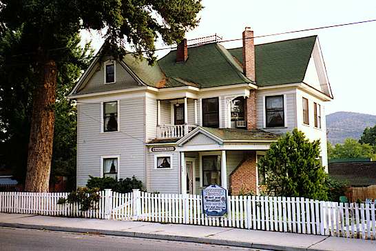
Stopped for root beers, headed back to the B&B. Checked in – more naps, showers. Out to do laundry. I strolled while Jacky slaved over hot washing machines. Roseberry House B&B, two blocks off Main street, is a rambling two-story house built in the 1800s. Very nicely kept – full of wallpaper, knick-knacks, lace doilies. The Roseberrys were prominent citizens in the late 1800s who raised four kids and then took in tourists. Bill and Maxine Ashmore, the current owners, also had four kids, three boys and a girl who was killed in a car accident. We stayed in what was the bedroom of one of the boys.
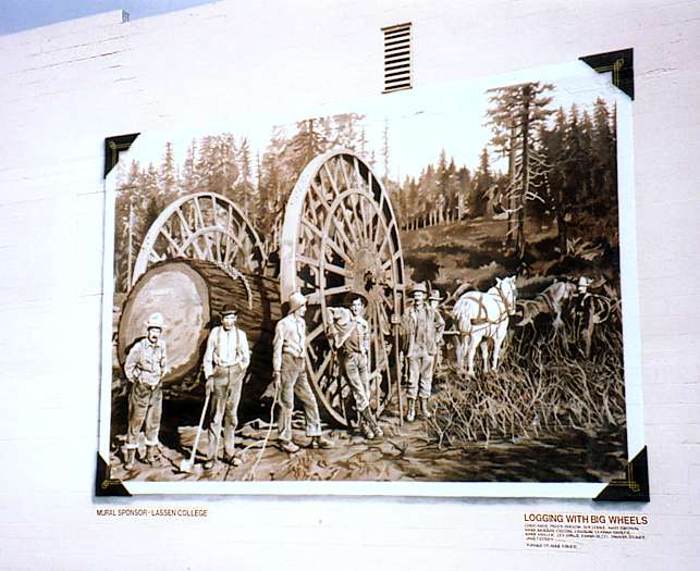
Saw a muralist at work on a scaffold. Asked him if he would mind if I took a couple of pictures. “Not at all,” he said, “I’d be honored!”
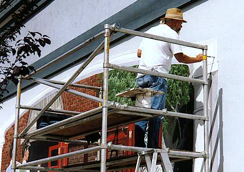
He told me he had had to interrupt work during the winter and had therefore left the unfinished mural with more complete cartooning than he normally would have. He had also done a couple of other murals in town, including one of Isaac Roop and his daughter Susan, the founders of the town. His name was Ben Barker; the Roop mural was also signed Leanna Lord Barker, presumably his wife.
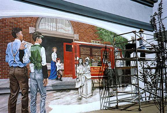
It’s hard to appreciate the scale of this mural. It helps to look at the concrete block texture of the building wall.
When I was putting this diary up on the web (February 1999), I looked for a hotlink to Barker. I’m sorry to have to report that the only thing I found was a reference to “the late muralist Ben Barker of Susanville.”
Old stone courthouse, classical and dignified. Some nice houses here, green lawns, flowers. Not hard desert. Some of the peaks south of town look a lot like volcanic cones. Passed a geothermal node, presumably owned by a power company. Nothing to see but a small building with a tank and a pipe coming out of the ground. It’s about time we started seeing evidence of vulcanism!
Clouds came over, breeze came up. Very pleasant as it cooled off. Ate at a Chinese restaurant – skipped the Szechuan entrées in memory of Carson City ’89. Crisp, almost raw veggies – broccoli, cauliflower, carrots, bell pepper, onion, water chestnuts, snow peas, celery, and some things I couldn’t identify. Great! We’ve been short on veggies lately. Asked for and got chopsticks. Couldn’t eat it all. Burp!
View Guestbook
Jacky’s home
Dave’s home
View old guestbook
Email: ![]()