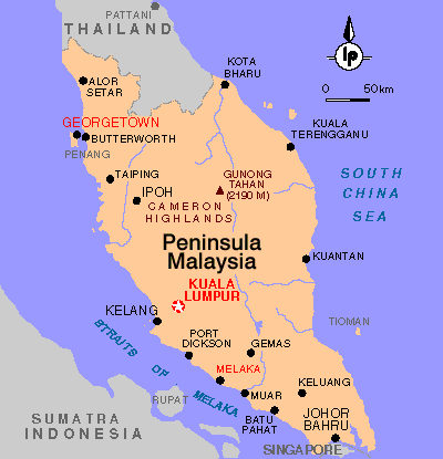
Malay Peninsula or Malaya (ancient Chersonesus Aurea), projection of the Asian mainland, extending generally south from about latitude 13°30' north to about latitude 1°22' north, and bounded by the Gulf of Thailand (Siam) and the South China Sea on the east, by Singapore Strait on the south, and by the Strait of Malacca and the Andaman Sea on the west.
The length of the peninsula is about 1210 km (about 750 mi), and the maximum width is about 320 km (about 200 mi). The Isthmus of Kra, the narrowest portion of the peninsula, has a minimum width of about 64 km (40 mi).
A discontinuous mountain range extends the length of the peninsula. Gunong Tahan (2187 m/7174 ft) is the highest summit. The vegetation is rich and varied. Dense, biologically diverse rain forest covers about half of the peninsula, though the rain forest is endangered by encroaching agricultural and commercial use of the land.
The fauna is similar to that of Borneo and Sumatra, except here it includes the elephant, rhinoceros, and tiger. The peninsula contains rich mineral deposits and is one of the chief tin-producing regions of the world. Other mineral deposits include silver and gold. Agriculture, carried on by 90 percent of the population, is the leading industry; the principal crops are rubber, tea, and rice.
Politically, the peninsula is composed of part of Myanmar (formerly known as Burma), part of Thailand, and part of Malaysia.
![]() States
States
![]() Tourism
Tourism
![]() National Symbols
National Symbols
![]() History
History
![]() Geography
Geography
![]() Flora & Fauna
Flora & Fauna
![]() Economy
Economy
![]() Culture
Culture
![]() Festivals
Festivals
![]() Transportation
Transportation
![]() Accommodation
Accommodation
![]() Foreign Exchange
Foreign Exchange
![]() Food
Food
![]() Fruits
Fruits