Walking The W&OD Trail
SEARCH THIS SITE | MAP OF THIS WEB SITE
|
|
Walking The W&OD TrailSEARCH THIS SITE | MAP OF THIS WEB SITE |
|
"Obviously the farther you get from Washington, the more rural the scenery becomes, but the view from the path is surprisingly attractive even through the close-in suburbs," -- Alan Fisher, Country Walks Near Washington.
Circuit HikesDifficult Run Loop Trail W&OD Mile Markers 14.5 - 16.5 This hike takes four hours. It roughly follows an equilateral triangle, one side being the bike trail, the second side being the Colvin Run Trail, the third side being Difficult Run Trail. Only one hundred yards of this hike are on roads. Click here for a map. Good places to begin are: Lake Fairfax Park; Hunter Mill Road at the W&OD or historic Colvin Mill, all of which have parking. 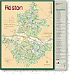 If you are interested in circuit hikes in Reston, check out the maps of Reston published (on the web) by the Reston Association.
The Reston Association boasts of fifty-five miles of hiking trails for jogging, walking or biking. Probably about half of these trails are mere sidewalks, but the other half are true trails. They form the best trails system in Fairfax County. Many circuit hikes are possible. A trail which passes the habitats of beavers is The Glade/Twin Branches Nature Trail, beginning as a natural-surface trail just west of Buckthorn Lane (Mile 15.4). After crossing Twin Branches Drive, it becomes a paved path, called "The Glade." The Western end of "The Glade" is Reston Ave. By turning North on Reston Avenue's sidewalk, you may re-join the W&OD at Mile 18.1, thus complelting a seven-mile circuit hike. Using Metro, it is possible to travel one-way on Metro and return on foot. This avoids out-and-back hikes in the Dunn Loring/Falls Church/Arlington areas. Utilize these Metro stations on the Orange Line: Dunn Loring, West Falls Church, East Falls Church and Ballston. Side Trails from East to WestIntersecting with Four Mile Run trail, but not with the W&OD, is Long Branch Trail, part of a network of trails in Four Mile Run Park. Some have compared this park to Rock Creek Park. Mile 2.3. Yet another trail in Arlington is Lubber Run Trail which does not connect directly with the W&OD, but which is reached by taking the first spur trail north-east of Arlington Boulevard, then straight on First Road N. for a half block, right on Greenbriar Street one block, and left on Arlington Boulevard for one block. Mile 2.8. At Bluemont Junction, near the caboose, a branch trail ascends the old railroad bed to Ballston and to Metro. Mile 3.0. Custis Trail. Enough said. Mile 4.0 Falls Church City's Four Mile Run Demonstration Trail. This path provides a pleasant alternative to one of the bleakest blocks on the trail, the block east of Lee Highway. Starting at bridge over Four Mile Run, Mile 5.2, leave the W&OD, going straight to Van Buren Street, and cross into Isaac Crossman Park. This trail follows Four Mile Run and Gresham Place to emerge at the corner of Lee Highway and Gresham Place, one-half block west off the W&OD crossing of Lee. Length: half mile. Condition: completed. (Mile 5.2 - 5.6) Difficult Run Trail. To Great Falls Park via a trail along the banks of Difficult Run. To Oak Marr Park in Oakton (outside of Fairfax City) going the other direction. Colvin Run Horse Trail Beginning one block off the W&OD, at #1807 Michael Farraday Court. (Mile 17.x) A natural-surface trail, it winds through the wooded valley of Colvin Run to Lake Fairfax Park. Inside this large park, generally follow Colvin Run on the south bank. On the eastern edge of the park, the horse trail resumes. It crosses Hunter Mill Road and it ends across Route 7 from Colvin Mill. Total distance: several miles. Directions: trail begins on the western edge of the rear parking lot of #1807 Michael Farraday Court. Other connecting trails which I classified as biking trails. Links
|