|
Nearby Towns & Villages

|
| Pamiers and its famous 3 bell towers - Click on photo for LINK |
The local town of Pamiers
is famous for its 3 bell towers and also is the birthplace of Gabriel Fauré, the classical French musician and composer.
It also boasts awards for the equivalent of "towns in bloom" - 'Ville Fleurie'.
Local facilities include good restaurants, bars, supermarkets,
large public indoor and outdoor swimming pools, (one of 50m). The main square of Pamiers, Place de la Republique is paved in red marble and a lovely place to sit with a
drink and watch the world go by. Every week, 3 large open air farmers markets are held on Tuesday, Thursday and Saturday mornings,
plus a "flea" market every Sunday morning. Nearby you will find the old Tour of the Cordeliars and the large Church
of Notre-Dame-Du-Champ. Pamiers
lies in an ancient alluvial plain of the Ariege River in the area called La Basse Ariege. Here there is a rich fertile soil
ideal for agriculture which is evident all around. Pamiers has 16,000 inhabitants and is the most important town in the department
as it is the economical capital of the Ariege.

|
| Place de la Republique - Pamiers |
The town itself dates back to the 5th century
and its name was derived from the fact that the land around the Ariege River at this point was divided into six sectors based
on a measurement called "Pams" (from the Latin "pannium" meaning pieces). Originally it was called "Ville
de Pams" - you often hear the word "Appamee" relating to Pamiers! In the 18th century a plural stance on the
word was introduced making the name "Apamias" derived from ecclesiastical language and also similar to the Occitan
language. The name "Pamias" still exists today on the town sign, alongside the French name Pamiers as you enter
the town via the old route from Toulouse, RN20.
Pamiers has the "Chemin de St Jacques de Compostella" (The Way of St James) - an ancient pilgrims
route from Arles to Santiago in northern Spain.

|
| Church at St Victor Rouzaud (on Chemin de St Jacques) |
The village of St Victor Rouzaud has a large
15th century church and a thriving community situated 13 minutes outside Pamiers and 5 minutes from St Victor du Fau. The
"Chemin St Jacques de Compostelle" (The Way of St James) runs straight through the village on towards Montegut-Plantaurel.
This was a pilgrims route to Spain. Using the GR78 route (national footpath) from Pamiers, it would take approximately 2.5
hours to get to St Victor Rouzaud.
Information on the Chemin St Jacques de Compostelle - look at "Pamiers - Montegut" section

|
| Chateau de Foix - Click on photo for Foix LINK |
Foix is the administrative
capital of the Ariege. An ancient town with a fine fortress perched on a hill above the town, called Chateau de Foix.
Simon de Montfort attacked the fortress many times without succeeding to capture it. It has 2 square towers dating back
to the 13th century and the round tower was built at the beginning of the 15th century. Cardinal Richelieu was determined
to dismantle the fortress, but again without any success. In times gone by, the Chateau was used as a prison. Foix has a good weekly market on Monday and Friday mornings.
Verniolle link
It is believe that Verniolle was a Roman settlement as many
objects and bits of pottery found there date to that time, 250 BC. Verniolle is first mentioned by Pierre, the future
Bihsop of Gerone (his brother was Raymond Count of Carcassonne) in 1008. In 1034 the name "Vernola" was mentioned
3 times in the Charter. At the beginning of the 13th century the church at Verniolle belonged to Saint-Antonin of Pamiers.
The village was never fortified but the Count of Foix, Gaston tried to build a fort in 1382, but this project was
eventually abondoned. However, there was a construction of a strong house between 1460 and 1517 to protec the village
from soldiers who were devastating the country at the time, following fights between the Bishop of Pmaiers and the wars
of succession from Foix. The Church of Saint Laurent was obviously demolished during this time as it was quoted
as having been rebuilt in 1551.
Today, Verniolle is a peaceful, charming village witha baker, restaurant
and other commercial enterprises and a beautifully restored Mairie and market square. Each Sunday morning, there is
a small open air market.
Saverdun Link
Saverdun is a town of approximately 4000 inhabitants located at 50 km in the South of Toulouse
is just off the RN 20 in direction of Andorra. The main town is on the side of the Ariège river, and is an altitude
of 335m approximately at its highest, but other parts of the town are slightly lowerer and built on slopes and alluvial terraces.
Saverdun sits where the two rivers, join on the Western edge of the alluvial plains of the Ariège and Hers. The ground
around this area is very fertile and there has been a lot of agricultural development with regards to growing cereals,
corn, sunflower and cattle breeding. The local economy has also grown through artisan and commercial activities.
Saverdun is located north of Pamiers and south of Toulouse at a height of 218-333 metres above sea level. It has a population
of approximately 4000 people on a land area of 44.04km2. The site of Saverdun was inhabited very early in history, because of its proximity of the river;
artifacts have been found dating back from the paleolithic period; tools and other objects made from stone. Other objects,
like weapons, going back to Bronze Age and Iron Age have also been found there. There is also evidence of Roman occupation
with the remains of villas which brought a diversity in the local population of Iberian and Celtic origin. This diversity
caused great invasions by the barbarians: Vandals, Visigoths, etc. which in turn caused the inevitable destruction of historic
buildings. The name Saverdun is of Celtic origin and it means strengthened height. In the Middle Ages, it was protected by
a castle built in a high elevation dominating the valley. Saverdun has been the centre of wars of religion related to
Cathar heresy. It was the official place of Protestant worship. It is believed that Pope Benedict XII whose name was Jacques Fournier was born in Saverdun (which
at the time was in the Comté de Foix) in 1280. Jacques became a Cistercian monk at Fontfoide Abbey, 15 kilometres
south-west of Narbonne; he later became Abbot of Fontfroide. He eventually left to go and study at the University of Paris
(which was renamed in 1970 La Sorbonne after the name of Robert de Sorbon who founded it in about 1257). In 1317 Jacques was made Bishop of Pamiers. He rigorously hunted
Cathars to try to wipe out Catharism. This was a name give to a Christian religious sect with dualism and gnostic elements
and flourished in the Languedoc region of France during the 11th, 12th & 13th centuries.
For his works he won praise from religious authorities but alienated local people. Jacques created the Fournier Register which was a set of records from the inquisition
into heresy run between 1318 and 1325. He launched an extensive inquisition in Montaillou which was one last bastions of the
Albigensian heresy. He conducted a campaign against the last remaining Cathar believers in this village, as well
as others who questioned the Catholic faith. This involved many lengthy interviews to extract information which
often involved torture. All the information was recorded in great detail and sometimes resulted an entire village being
arrested as it happened in 1308. In 1326, on
the successful rooting out of what were believed to be the last Cathar adherents in the area, he was made Bishop of Mirepoix.
A year later, in 1327, he was made a cardinal. In 1334 he was made Pope Benedict XII and was based in Avignon.
He died on April 24th in 1342. The manuscript of Jacques Fournier's Inquisition Record is currently found in
the Vatican Library and modern editions are available in Latin and French. "Verdun" a city in Quebec in southeastern Canada was named after it was granted to Zachurie
Dupuis a French military pioneer who was born in Saverdun.
Saverdun with its infamous links to Cathar history is a 15 minute drive from Pamiers. There is a flea market each
Saturday morning held in the town centre.

|
| Mirepoix - click on photo for Mirepoix LINK |
Mirepoix, a very
pretty medieval town about 25 minutes away by car. Originally the town of Mirepoix used to be part of the County of
Foix. In 1207 the Count granted it a Charter. Catharism was becoming more widespread and there were thought to be about 50
"Perfects" houses in Mirepoix. In 1209, Simon de Montfort captured Mirepoix and then entrusted it to his Lieutenant Levis. Pierre-Roger de
Mirepoix, tried to retake his town in 1221 but unfortunately died during the siege. In 1279 a dam broke up at Puivert and the original town thought to be built
in the 1100's right next to the River Hers, was destroyed and carried off in the floodwater. Jean de Levis rebuilt Mirepoix
in a slightly different location in a more regular style of the original bastide towns. The timber framed houses were built
over hanging the pavements - "couverts" which were there to protect the people from the weather. The "Consuls" house, now the hotel called "Maison
de Consuls" has beams decorated with carvings of human heads or monsters. There is a very good large open air market on
Monday morning and a farmers market on Thursday morning.

|
| Click on photo for link to Carcassonne |
Carcassonne, a 12th
century fortress town which summarises all that which was the best military architecture of the Middle Ages. Viscount Trencavel
surrendered Carcassonne during the Albigensian Crusade and it was then given to Simon de Montfort and later to the King of
France. Carcassonne was then annexed to the Royal Estates. It was originally built over an older construction dating from
the Dark Ages which had already replaced a Gallo-Roman building.
Carcassonne was one of the main towns mentioned in the "The Labyrinth", the book written by
Kate Mosse.
Castelnaudary Link
The large town of Castelnaudary which
is also situated on the Canal du Midi is the capital of the Lauragais. It is situated 50km south east of Toulouse
and the Mediterranean and was a Roman settlement area. In 1211 after some of the had departed the town, Simon de Montfort
was beseiged here. It was thought to be a weak town by the Counts of Toulouse and Foix.
It gained its prosperity
during the 17th century when it was a large exporter of agricultural and manufactured products. There is a 7 hectare
"bassin" which is the largest area of open water on the Canal du Midi and is a popular tourist area for sailing
and boating. On 15th May 1681 work began on the Canal du Midi here
and the town is famous for the 4th Foreign Legion Regiment which started in 1976. Castelnaudray is also the self proclaimed
capital for the recipe of Cassoulet.

|
| Click on photo for more information on Carla Bayle |
Carla Bayle, a fortified village
and Hugenot citadel situated on the top of a hill between the Rivers of the Leze and the Dourne and at the mouth of the Arize.
One of its most famous inhabitants was the philosopher, Pierre Bayle. The views of the surrounding valleys from this village
are wonderful. Surrounding the bastide village are ancient and beautiful ramparts and equally stunning houses. Carla Bayle
is famous for its inhabitants who are mainly artists and crafts people. Many arts and crafts exhibitions are held there throughout
the year. There is a superb man-made lake just below the village which is open all year round.
It is set on 12 hectares and facilities include, swimming, sailboarding, fishing & canoeing. The lake also has a
picnic area.
Carla Bayle has a market each Sunday morning.
St Martin D'Oydes is situated 16km
NW of Pamiers and is a medieval circular bastide. It was built like this mainly for the defence of the inhabitants; the houses
surround the church. In the 19th century a moat was built as a 3rd line of defence for the church but was later covered because
of the stench of polluted and stagnant water. If both the moat and houses were breached by attackers, the inhabitants took
refuge in the clock tower. This is also where Tony Blair (ex-Prime Minister of Great Britain) and his family had their holiday
in summer 2001.
Mazeres
is a very pretty 13th century "bastide" (which means hilltop town) town situated adjacent to the Hers River.
Gaston de Foix, Duke of Nemons was born there. In 1515 he lost his life at the Battle of Ravenna. A medieval pageant
is held there each summer. Other events include a large open air market each Thursday morning and a tractor fair each Spring.

|
| Eglise at Vals - click on photo for Vals LINK |
The village
of Vals just off the Mirepoix road is a medieval village with cave dwellings in the rock next to a cave church
constructed in the 12th century. Inside it is decorated with Romanesque frescoes. Some archaeologists believe that the village
may have been a religious Roman site too.
Like all the area, the town of Saint-Girons
saw a Roman occupation. St-Girons is situated in the Courserans area of the Ariege and has a long association
with cigarette-paper manufacture. The most striking thing about St-Girons is its central pavements, made of a local reddish-pink
marble with finely chiselled gutters to take the rainwater from down-pipes. And although there are no other memorable sights,
it's a very pleasant town, with a folklore festival in mid-July and a theatre festival in early August.
At the Pont-Vieux, there are picturesque rapids on
the River Salat. The bridge leads you towards the old commercial centre of the town on the right bank, with some marvellously
old-fashioned shops, their fronts and fittings unchanged for generations. To the right, past the tiny Cathedral, is the Place
des Poilus, which hosts the faded elegance of the Grand Hôtel de France and the equally old-fashioned Hôtel de l'Union, where
you can still stay. The latter's ground-floor café is a splendid balconied period piece facing the riverside Champ de
Mars, a wide gravelled allée of plane trees, which provides the site for a big general market on the second and fourth Monday
of every month, and for a regular produce market every Saturday morning.
There were a number of escape routes during
the World War 2 through France but the Comete Line, the Pat O'Leary Line and the Marie Claire Line were the most famous. One
of the O'Leary networks went through central France to Agen & Toulouse then to the central Pyrenees to the starting
point of "Le Chemin de la Liberte" at St Girons. The high mountain route into Spain was carefully chosen as it
avoided all official checkpoints. Between 1940 & 1944, there were 33,000 successful escapes along the entire length
of the Pyrenean chain and 782 escaped over the mountain peaks of the Ariege. During the war several escape trails were
established near St Girons and other towns and villages surrounding it like Foix, Tarascon, Aulus-Les-Bains, Massat, Castillon,
Seix & Seintein all had invisible mountain routes towards the Spanish frontier. By the beginning of 1943 German
surveillance had increased often due to the betrayal by Frenchmen who worked for the feared Vichy-run paramiltary force "La
Milice" and there were many ambushes along the trails. Despite this increased surveillance the St Girons-Esterri escape
route via Mont Valier remained operational until the end of the war.
A booked called "The Freedom Trail" published by
Scott Goodall gives a detailed guide to Le Chemin de la Liberte, historical notes of the area and the walking trails from
St Girons to Spain.

|
| Click on photo for St Lizier LINK |
St-Lizier sits on a hilltop and
is full of history; it is walled, arcaded, cobbled, cathedraled, half-timbered, pretty and and very quiet outside of
summer. Architecturally the most interesting
building in town is the Cathédrale de St-Lizier , with its distinctive octagonal tower posing picturesquely against
the mountains to the south - is open to the public between May and October. Inside are some twelfth-century frescoes faded
almost to invisibility, and a fine Romanesque cloister, also twelfth-century, with an array of unique, sculpted column capitals.
A second cathedral, Nôtre-Dame-de-Sède, within the grounds of the bishop's palace, is closed indefinitely
for renovation, though the palace is also home to the Musée Départmentale de l'Ariège on the first
floor which contains a permanent ethnographic collection devoted to the Vallée du Bethmale. It is, however,
worth walking up to the palace anyway, for views over St-Lizier, and continuing on round the old ramparts. Tarascon-Sur-Ariege
is a small utilitarian metallurgy and iron ore mining town but is in reality one of the most fascinating places in Europe
and is situated on the Ariege River. The geography of the area is stunning, created by glaciers and large rivers in prehistoric
times. There are many caves around Tarascon which were occupied by Stone Age man and plus many artefacts have been found in
the area. Caves were made in this area of the Ariege due to the abundance of limestone. The finest of the caves are at Niaux
"Grotte de Niaux" only 2kms from Tarascon. Cave paintings are still visible and tours around the caves around
Tarascon are very well worth a visit. There is also a very informative prehistoric park which is an interesting place to visit
for adults and children alike. In
the centre there is the church of St Michel presiding over an arcaded square with small parts of the surviving medieval walls.
Walking further on, from the Tour du Castella, which is now a clock tower there are views over the five valleys which all
meet here. Tarascon hosts 2 major livestock fairs at the beginning of May and at the end of September for the transhumance. Tarascon and some of the highest peaks around it are often used
as part of the major and famous cycling race, the Tour de France each year. Ax-Les-Thermes Link
The spa town of Ax Les Thermes is 20 kilometres
southeast of Tarascon on the Ariege River. The town is completely walled in by mountains and its location is an ideal base
for exploring the surrounding peaks and as a stopping point on the way to Andorra or the N20 going to Font-Romeu and then
on to Perpignan and the Mediterranean.
The town is quite pleasant and has a few medieval buildings
and above Place du Breilh, the church of St Vincent is of architectural interest for its Romanesque tower. Just across the
road you can dangle your feet for free in the Bassin des Ladres, a pool of hot sulphurous water which is the only remenant
of the hospital founded in 1260 by St Louis for soldiers wounded in the Crusades
Narbonne Link
Narbonne known as Narbona in Catalan and Occitan
and the Roman Narbo is the largest commune in the Aude department in the Languedoc-Roussillon region. It is 849 km from Paris
and is it the Sous Prefecture of the Aude. Narbonne was once a prosperous port and it is now located about 15 km from the
shores of the Mediterranean Sea, but fell into slow decline in the 14th century, for a variety of reasons. The decline was
mainly due to a change in the course of the Aude River which caused increasing silting of the navigational access. The Aude
river had a long history of overflowing its banks, fluctuation in flow, direction and sediment deposit and as the Mediterranean
sea level slowly rose the 'sea port' aspect of Narbonne was no more
During the 16th century, the people of Narbonne were keen to
maintain a link to important trade, and so began costly works to the Aude River's access to the sea, so that it would remain
navigable to a limited draft of vessel and also a link with the Royal Canal. The works were finished with the construction
of the Canal de la Robine, which finally linked to the Canal du Midi (then the Royal Canal) in 1787.
Limoux Link
Limoux is a market town and a
sub-prefecture in the Aude, a part of the ancient Languedoc province and now the Languedoc-Roussillon region. It lies on the
River Aude and is about 30 km due south of Carcassonne.
The town is perhaps best known for its Winter festival called
Fècos, often referred to (inaccurately) as a Carnival or fête. Fècos is the name of a dance characteristic
of the festival). It is generally referred to as Carnaval de Limoux in French language. This takes place between January
and Easter and is conducted in Occitan,, the traditional language of the area, hence Laugue-d'Oc ("tongue" - language - of
the Occitans). The cafe scene is dominant in Limoux where food and drink represent the dominant cultural pastime. A
local refreshing sparkling white wine is also made here, which is very pleasant on a warm afternoon.
Fanjeaux
is located in the Aude, 360 metres above sea level hanging on a rocky promontory. It is in the Lauragais area between the
Pyrenees Orientales and the foothills of the Massif Central.
It has an ancient Oppidum Roman temple and a town which had
3000 inhabitents which was destroyed many times. Fanjeaux, celebrated by the troubadour Peire Vidal, was very much related
to the events which shook Languedoc in 13th century and was one of the bastions of the catharism in Lauragais. Fanjeaux
was in the centre of preaching against the Cathare heresy. The town had many noblemen and was a major centre of Catharism.
Rennes-Les-Bains Link
Rennes-les-Bains
is a spa village in the Corbieres region in the heart of Cathar country. The natural hot spring waters have been enjoyed by
bathers for thousands of years and was in fact popular with the Romans who had a colony, "Colonia Narbo Martius" in Narbonne.
The water is about 46° centigrade and the village has an outdoor heated swimming pool, hammam or Turkish bath, jacuzzis, and
gym. Today they are still used as a cure for rheumatism and skin problems. The village is in the valley of the River Sals
(a saline/salty river) which is 48km from Carcassonne, 20km from Limoux and 3 km from Rennes-le-Chateau.
Rennes-les-Bains has been mentioned in many books in connection
with Rennes-Le-Chateau. Dan Browns novel the Da Vinci Code and in Kate Mosses novel Sepulchre written in 2007.
The village is also well known for its curé, Abbé Henri Boudet, its supposed links with Bertrand de Blanchefort and the Grand
Master of the Knights Templars.
The village has been twinned with the city of Rennes in Brittany
since 1985.
Rennes-Le-Chateau Link
Rennes-le-Chateau, Rènnas del Castèl in Occitan, is a small and medieval castle village
near Rennes-les-Bains. It is very well known and many people visit it due to the fact that it is the centre of many
conspiracy theories. In the 1950s a local restaurant owner, Noël Corbu tried to increase business and started
to spread rumours of a hidden royal treasure which had been found by a local priest in the 19th century inside
a Visigothic pillar of his church. This priest was Father Berenger Sauniere; he had supposedly found proof of a secret
society which was known as the Priory of Sion. The story and the society were found to be a hoax, but became the centre of
hypotheses in documentaries and books such as the Holy Blood Holy Grail and the The Da Vinci Code.
The area has beautiful scenery with rocky jagged ridges,
deep river canyons and limestone plateaux and caves. It was a Visigoth site in the 6th & 7th
centuries and it was the site of a medieval castle which existed in 1002, although there are no remains above ground now.
There is evidence of a church, Church of Mary
Magdalene which is as old as the 8th century. This became a ruin by the 10th or 11th century
whereby another church was built on the site. This church survived and was renovated in the 1800s by the local priest,
Berenger Sauniere. He had come into quite a bit of money very quickly and added some features to the church which appear unusual
to modern eyes.
The area has become
the focus of increasingly sensational claims involving the Knights Templar, the Priory of Sion, the Rex Deus, the Holy Grail,
the treasures of the Temple of Soloman, the Ark of the Covenant, ley lines and sacred geometry alignments.
The village of Camon is built around an abbey which Charlemagne probably
built in 778 although written evidence suggests that it only existed from 923, and according to the Saint-Benoit the fortified
abbey was destroyed twice. The newly appointed Bishop of Mirepoix, Philippe de Levis in 1502 (prior to that of Camon)
ordered the rebuilding of the abbey and its buildings that one can admire and see today with its ramparts which encircle the
village.
Camon is one of the most beautiful villages of France with its little streets with roses
climbing up the outside of houses that line them. Occasionally In the centre of Camon during the
summer months there are evening processions with candles which are also used to illuminate the ramparts. There
are wonderful artisan markets and floral festivals.
Chalabre is a commune in the Aude department
and is a relatively unspoilt bastide with shady streets and alleyways. Industry
in the town died out about 70 years ago but there are still buildings relating to it around the
village.
Like many villages in the region the population has dropped from about 1800 in 1962 to just under 1200
in 1999. The road to Lac de Montbel runs through Chalabre and encourages visitors to stop and visit
the village. The land around the village is very fertile with good flowing rivers and the climate isnt
as dry as it is on the coast. Chalabre has its own Chateau which dates back to the 12th century. Many
Medieval pageants are often held here which normally include Medieval dancing to jousting.
There is also a local
church Saint Pierre which dates from 1552 with its own bells from the same time. A
plaque can be seen in the village to celebrate the birth of Joseph Raynaud who was born in 1911. He joined
the local Maquis in the Ger during the war and was killed by the Nazis on 7th July 1944.
Find out more about towns, villages, flora & fauna of the Ariege & Aude
Fishing Fishing is possible at Sabarat, Lac de Carla-Bayle a 20 minute
drive from us or nearer in the Ariege River close by, plus at Lac Mondely & Lac Montbel. A fishing permit for holidays
cost about 30 Euros and can be bought locally. Link to Mas D'Azil

|
| Grotto at Maz D'Azil |
One of the most famous grottos in the World and an exemplary
site of a prehistoric dwelling and also served as a refuge for local persecuted people, some Cathars and also Hugenots.
The main road runs through the grotto and inside it is a Museum of Prehistory.
Photos of the paintings at the Cave at Niaux Link
The Grotte (cave) of Niaux (near Tarascon-sur-Ariege)
The village Niaux is situated on the Vicdessos River in the Ariege.
The cave site was first visited in 1864 and explored further during the 20th century. The wall
paintings are finished in a black-outline which is typical of the Magdalenian period of Paleolithic art approximately 11,000
to 17,000 years ago. Niauxs drawings have been carbon dated and were thought to be from the era 13,000 14,000
years ago.
Like many caves, Niaux has distinct areas, one of which is the "Salon Noir" which has panels of bisons and
horses drawn in outline. There are also drawings engraved into the clay floor which include fish and bison. Another part of
the cave known as the Réseau Clastres which is connected to Niaux but is in fact a separate cave. This cave was discovered
in 1970 and contains five paintings and is on display at the Park of Prehistoric Art, near Tarascon-sur-Ariège.
Visits to the cave are strictly controlled in order to keep an even temperature of 12 C to preseve the wall
paintings of bison, horses and ibex. The caves are not lit and visitors are given torches in order to protect the paintings.
Ski-ing Locally and Snow Sledging

|
| Plateau de Beille, excellent for cross country ski-ing |
Downhill ski-ing is possible at Ax Les Thermes, Les Monts D'Olmes
and Ascou Paihes - all of these resorts are about 50 minutes away. Cross country ski-ing and raquettes walking at Plateau
de Beille near Les Cabannes is about 40 minutes away. Just before the summit at Plateau de Beille is an ideal spot
to park up, arrange your picnic and champagne and watch your children, friends and family sledge to their hearts content with
the panoramic views over the Pyrenees.
Skis, sledges and all winter sports equipment can be hired or
bought from most of the resorts.
Downhill Ski Resorts in the Ariege
Ax Les 3 Domaines - 1400-2400m - 75km piste
Guzet - 1100-2100m - 40km piste
Les Monts D'Olmes - 1500-2115m - 18.5km piste
Ascou Pailhes - 1500-2000m - 20kms piste
Mijanes Donezan - 1530-2000m - 9kms piste
Goulier Neige - 1500-2000m - 5kms piste
Cross Country Ski Resorts in the Ariege
Plateau de Beille - 1800-2000m - 75kms piste
Domaine du Chioula - 1240-1640m - 60kms piste
Etang de Lers - 1300-1615m - 30kms piste
La Tour Lafont - 1250-1500m - 15kms piste
Other Links
Click on the logos or words below to enter each website
| Click on banner to enter their website |

|
| Midi Pyrenees Properties agency - specialist property estate agents |

|
| Click to enter site |

|
| Hiking in the Pyrenees - Click to enter site |

|
| Click on Link to Dotty Kitchen Catering in the Aude region |
Link to Owners Direct - www.ownersdirect.co.uk where these gites are also advertised
Link to www.tourist-paradise.com
|
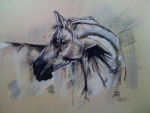
| Link to Claire Howlett - portrait painter of animals, pets, natural life and seascapes |

|
| Take a look at SARA SPENCER'S artwork and photography |
| Your Commission-Free French Property Finder |

|
| French Property Centre |

|
| All sorts of information about the area, forums, classified adverts etc |
Link to CATHAR COUNTRY INFO

|
| The Ariege Network |
|