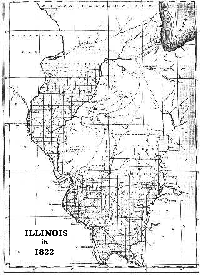
Illinois Maps


  Home  |
 Why "Egypt"?  |
 The Birger Gang |
 Great Tornado of 1925  |
 Herrin Massacre  |
 Railroads & So. Illinois  |
 Illinois Maps


  Maps currently available:

IIllinois in 1822

RR in 1949Counties in Little Egypt

RR in 1949Railroad maps on the Railroads & southern Illinois page
 
Illinois as a young state in 1822

This 1822 map clearly illustrates the early settlement patterns of the four-year-old state. White settlers had first migrated into what became southern and western Illinois. This may surprise many since the Chicago and central plain areas are what first come to mind when most people think of Illinois. In fact, Illinois' first heavy commercial activity centered on the Mississippi and Ohio river valleys. 

Careful scrutiny of this unique image, while difficult due to the small print, can provide some interesting insights in Illinois and Southern Illinois history.


1822 Illinois map
(click on image to see enlarged version)
Counties in Little Egypt 

This image simply shows the counties that many consider to be included in Little Egypt.

Counties map
(click on image to see enlarged version)


  Home  |
 Why "Egypt"?  |
 The Birger Gang |
 Great Tornado of 1925  |
 Herrin Massacre  |
 Railroads & So. Illinois  |
 Illinois Maps

Last updated August 8, 1999
Please send comments & suggestions to: [email protected]


This page hosted by  Get your own Free Home Page

1