
|
|
|
|
|
|
|
|
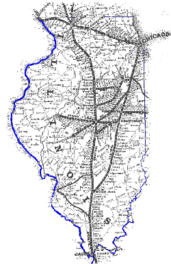
| Illinois
railroads in 1876
Railroad networks were relatively abundant in Illinois, even as early as 1876. This image, taken from an 1876 Illinois State Atlas, shows the railroad lines and cities and towns they served to connect. The railroad lines were established primarily to transport raw materials, produce, and finished goods, of course. Towns and industries sprang up along the path of the railroads. Therefore, the selection of a railroad's path could mean the death of towns not destined to be on the route, or new opportunities for those who chose to live along it. Note the lack of railroads in Southern Illinois in 1876, relative to the central and northern portions of the state. This is a clear indicator of how development had shifted north significantly since 1822. Some expansion of rail service would soon occur in Little Egypt with the discovery of abundant coal beds in the region. |

(click on image to see enlarged version) |
|
|
||
| Illinois
Central Railroad
The Illinois Central Railroad was the first great railroad network planned in the midwest, and the company was a leader in facilitating the development of Illinois and the region. The system began with its primary function being the transportation of coal from Illinois and Kentucky, but grew in importance for the delivery of agricultural and manufactured goods, and passengers as well. The railroad was chartered on February 10, 1851, and opened its first section from Chicago in May, 1852. By 1856 it was the longest railroad in the world. Eventually, by the late 1800s, the Illinois Central extended as far as Albert Lea, Minnesota and Baton Rouge, Louisiana (see map). In the 1900s the line reached west to South Dakota, south to New Orleans and Miami, east to Indianapolis, and north to Madison. Today, the Illinois Central, while not as dominant as it once was, remains as a major rail carrier in Illinois and the region. Source: Modelski, Andrew M., Railroad Maps of North America, 1984 |
(click on image to see enlarged version) |
|
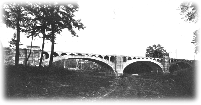
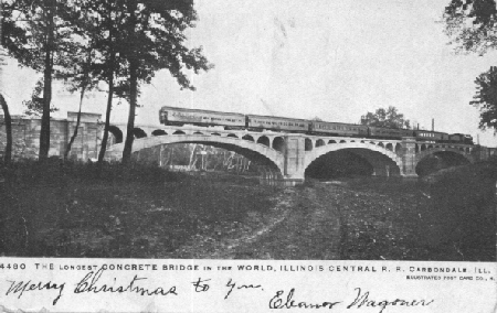
The postcard below dates back to 1906, and is a photograph of the Illinois Central's bridge over the Big Muddy River, between Carbondale and DeSoto. The postcard claims the structure to be the longest concrete bridge in the world at that time. Erected in 1902, the bridge still stands and carries railroad traffic daily, though the concrete is crumbling in places. This postcard carried Christmas greetings from Eleanor Wagoner to Mrs. Quinn Sickler of Sand Ridge in 1906. The postcard photo was used to create the animated train image above.
| Illinois railroads in 1949
By 1949 Southern Illinois was criss-crossed with a network of railroads. Many of these routes had been developed in the late nineteenth century and early twentieth century in order to access coal mines and deliver the material to markets. In addition, the railway systems provided passenger service during the height of rail travel in the '20's and '30's. The lines were owned by a variety of railroad companys, including the Illinois Central, Missouri Pacific, New York Central, and Gulf, Mobile, and Ohio systems, among others. Additional track was owned by coal companies. In truth, rail was already in decline by 1949, and over
the next several decades much of the track was pulled up and the railroads
abandoned (see next paragraph). |

(click on image to see enlarged version) |
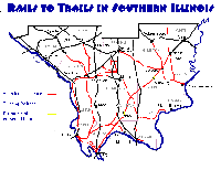
| Rails to Trails in Little
Egypt
Today, well over half the railroad beds in Little Egypt have been abandoned. Tree-lined, abandoned railroad beds are visible today as they criss-cross the countryside and cut through towns. In many ways they are a sad reminder of more bustling, energetic and certain times. Little has been done to take advantage of this incredible resource and the legacy left behind. One alternative that a growing number of communities are pursuing is to convert old railroad beds into recreation trails. They make ideal paths for biking, jogging, and walking since they are level, raised, and often do not require extensive engineering and labor to convert (compared with creating entirely new trails). Currently, as far as I can discern, the only effort to convert railroads to trails in Southern Illinois that has actually resulted in new bike trails is taking place on the old New York Central line running from Vienna to Harrisburg. Portions of this trail are complete, including a great stretch at Tunnel Hill that that runs through the old railroad tunnel. If you are aware of other efforts in the area, or have more accurate information regarding the status of railroads, please let me know. |
(click on image to see enlarged version) |
|
|
|
|
|
|
|
|
Last updated August 15, 1999
Please send comments & suggestions to: [email protected]
This page visited
times since August 15, 1999
This page hosted by ![]() Get your own Free Home Page
Get your own Free Home Page