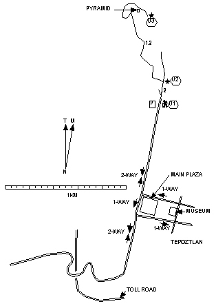
Tepoztlán |
Length each way = 1.4 km. Exertion index = 360 going 10 returning. Maximum elevation = 2101 m.
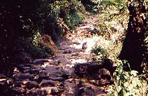
 It's a
little bit of a stretch to call this a hike. The trail is almost
entirely on stones that have been laid step-like up a very steep hill.
But the vegetation is natural and the stones were laid hundreds of
years ago by the Tlahuica people who settled here. About 50 meters from
the top there's a steel ladder which probably was installed later. The
pyramid is a small temple platform with remnants of Mexica (Aztec)
decorations.
It's a
little bit of a stretch to call this a hike. The trail is almost
entirely on stones that have been laid step-like up a very steep hill.
But the vegetation is natural and the stones were laid hundreds of
years ago by the Tlahuica people who settled here. About 50 meters from
the top there's a steel ladder which probably was installed later. The
pyramid is a small temple platform with remnants of Mexica (Aztec)
decorations.
The trail up to the pyramid begins at the north end of Cinco de Mayo Street which is the main street through town. At the main square if you're driving you have to go right and go around the block because of one-way streets. On the way you'll pass the museum which is worth a stop.
At the north end of town Cinco de Mayo Street ends directly at the trail. There is a paid-parking lot there. Also there is a fee to see the ruins which is paid at the top of the trail. A sign at the bottom indicates how much the fee is. You can hike up for free.