DAY 3
DAY 5
FINISH:
miles
Miles City, MT
2904.7
to Jamestown. I exited the Interstate at Jamestown and headed north onto Route 281
through towns such as Carrington and Minnewaukan until I reached Route 2 near
Churchs Ferry. I traveled west on Route 2, and about a half hour later, I saw a sign
which caught my eye - "Geographical Center of North America 5 Miles." This was an
attraction which I didn't know I would be seeing, and it's the type of thing I would go
many many miles out of my way to see, so it was just plain dumb luck that I found it.
Actually, you could say that it found me. The Geographical Center of North America
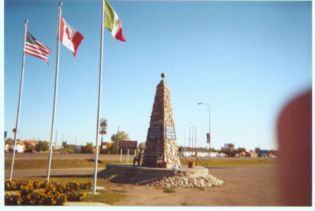
diner, at the intersection of Route 3. At
the Geographical Center of North
America, you can read a bit about its
history and how the location was
determined. There is also a directional
sign located there, which shows you
distances to 4 faraway locations in
North America (see picture to the right.)
From Rugby, I headed north and west
through Bottineau and Westhope on my
way back into Canada. At the border,
the customs official asked for my
destination. I replied "Saskatchewan,"
to which he replied "You can fit 4
Texases inside of Saskatchewan; could
Rugby, North Dakota
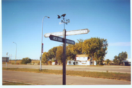
Acapulco, Mexico 2090 Miles
Lubec, ME 1500 Miles
Arctic Circle, Canada 1450 Miles
Neah Bay, WA 1100 Miles
in Saskatchewan before, and that I would be there only for a few hours, driving through
the southeastern part of the province. That answer seemed acceptable to him, and he
let me on my way. I actually had to drive through Manitoba for about a half hour until
I reached Saskatchewan. I drove through a series of very small towns in
Saskatchewan, until I reached Estevan. With a population of only about 10,750,
Estevan would be the largest town I would pass through in my 123.5 miles in
Saskatchewan. In Oungre, I headed back south across the border into Fortuna, North
Dakota. Once again, I was questioned at the border, a series of questions and answers
which led to me being asked the question "You're coming from New York, driving
through Saskatchewan, and heading to Montana?! Can you explain that?" I realized at
that point that being a young, single male with very out-of-state plates must make me
look suspicious (more about that in Day 5...).
I headed into Williston, North Dakota, and then onto Alexander, after which I left
Route 85 and went onto Route 68 to bring me into Montana. It was at 3:05 PM MDT
crossed into Montana, giving me all 48
continental United States. I stopped the
car and stood at the border for 5 or 10
minutes, soaking in the feeling of
having just accomplished this major
feat. I stared at the State Welcome
sign, an old, colorful sign in the shape of
Montana," behind which was located a simple sign which read "Richland County." I
drove on, still high on the feeling of having made it to each of the 48 lower states, as I
made my way onto Route 16 and then I-94. I stopped in Miles City, the largest city in
SE Montana with a population of about 8,500, where I spent the night.
Note - I had been to the rest of the western states before on a month-long road trip
with my family, but I was only 9 years old at the time, and don't remember too many
details about that trip. When I visited each of these states in this road trip, you could
say I was visiting them again for the first time.