|
|
Tourism in Gharwal
Uttaranchal is also a
‘paradise’ for nature lover’s and adventure sports enthusiasts. Mussoorie,
the ‘Queen of Hills’ Nainital, the ‘Lake District’ Almora, the ‘Switzerland
of India’ Ranikhet, Pithoragarh, Pauri and Munsyari are just few highlights
for the nature lover’s. For adventure and excitement, one may choose
Mountaineering (Bhagirathi, Chowkhamba, Nanda Devi Kamet, Pindari,
Sahastrataal, Milam, Kafni, Khatling, Gaumukh), Trekking, Skiing (Auli,
Dayara Bugyal, Munsyari, Mundali), Skating, Water Sports like rafting,
boating and angling and Aero Sports like Hand Gliding, Paragliding (Pithoragarh,
Jolly Grant, Pauri). The State is also a treasure house of exotic flora and
fauna and is an ideal location for eco-tourism, as well as wildlife tourism.
The world-famous Corbett National Park is the pride of Uttaranchal. Other
important sanctuaries are, Rajaji National park, Govind Wildlife Sanctuary,
Asan Barrage, Chilla etc. Last but not the least, the rich cultural
traditions and the cool and invigorating climate of Uttaranchal sums up for
a perfect holiday destination to relax and unwind.
|
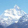
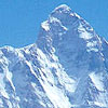
Peaks of Gharwal
Himalya Region is spread over to the Haridwar it is
in the North of India. Mostly peaks which are at 6 to 7 thousand
feet are covered with snow.
-
Nanda (Trisuli or Nanda
Devi peaks):- This Mountain has four
peaks. Nanda Trisuli is at 25,660ft height. Dunagire’s
height is 26,104 ft, Nandakot is 22,530ft, height and
Changbang named peaks at 22,416ft, height. These peaks are
situated at the north of Gharwal. These three peaks are called
trisuli because the trisul has the three points. In the east of
there peaks. the gauri river exists, which flow towards Kumaun
region and in the west there is river Pinder which flows in
Gharwal and meets River Alaknanda in Ruderprayag. These three
peaks makes a trisul so it is also called the trisul of lord shiva.
at the base of Trisuli peaks there is a place called hans kund
which is at the height of 13,000ft, At the twelth month of the
year a fair is held here, thousand of people came here for
worship. Worship:- People take there a sheep of four horns, they
left the sheep there after worship the sheep goes to the mountain.
-
Gaumukh:- The famous river
Ganga comes from the Gaumukh the peaks of Gaumakh mountain is
known as sato-path or sumeru peak. which is at the height of
23,660ft, The north portion of the peak goes to the top of
Kedarnath & ends at the peak known as Srikanth. this is at the
height of 20,130ft, at the Northen west side there is the
Chaukamba mountain. People belive that on this mountain lord shiva
left Ganga to the earth.
-
Bandarpunch:- Three peaks
exists in this mountain which are in front of each other, one is
Srikantha peak which is at the height of 20,135 second is
banderpunch which is at the height of 20718ft, third one is
Yamunotri peak which is at the height of 20029ft, these three
peaks are known as Bandarpunch peaks this Mountain is situated is
Rawain at the south there is Yamunotri at the east side siaghad
flows and at the west there flows River Tonse. This peak is called
Bandarpunch because it is believe that lord hamuman came here
after destroying lanka and worship here for many years.
- Three peaks up side
Kedarnath:- Three peaks are at a same lan upside to Kedarnath
one is known as SwargaRohini peak. Height of the first is 20,695
ft, second 22,840ft, & the third as is at the height of
21,535ft
- Chawkamba:- It is at the
height of 2,000ft,
|
|
|
Approach to Harkidurn:- By Dehradun (nearest
Railway Station) After first 30 Km. there is Mussorie tourist place
situated at the top of Hill, it is also called the queen of Hills.
Mussorie has its two season for tourism summer & lointer, people
came here to arrived heat in summer and to see the snow beauty in
winter after Mussorie there is Kaompti fall. Which is 10 km. from
Mussorie, Kaompti fall is also a tourist place, there are many & big
water fall in Kamptie.
People injoy swimming in the pool & injoy the beauty of the water
falts. Then after the run of 35 Km. there is a small halt called
Damta which is situated one side of River Yamuna. Damta is famous
for lunch, Dinner, people always stop here in journey for lunch.
Then along with River Yamuna there is Naungaon here the way divided
one is to Barkot (Yamunotri) & other is for Harkidun.
After 19 Km. from Nauongan there is the last market called Purola.
Here people of the above region came to sell & buy the needs. After
40 Km. there is Sankri (Tourist Rest house) then Saur 12 Km. by
trek, saur to taluka 11 km. by track (second halt) taluka to osla 14
km. by track. (third halt) then osla to harkidun 13 km. by track
(fourth halt)
|
|
|