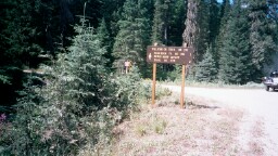
Trail 261
Tillicum Creek
This trail runs from US Forest Service Road 1103 to Trail 379 (the North Fork Grassy Top Trail). Upon arrival at Trail 379, the adventuring soul could elect to follow Trail 379 to Grassy Top Mountain or to follow Trail 379  back to Road 302 at a point approximately 2 miles north of Road 1103. This would make for a nice loop were it not for one small problem. Trail 379 is not being maintained over its entire length, making passage extremely difficult.
To reach the TillicumCreek Trailhead, head north on Highway 57 from Priest River and follow it until it ends (about 5 miles north of Nordman), then proceed along US Forest Service Road 302 until you come to the trail marker shown in the photograph at the right. Turn left at the trail marker and cross Granite Creek. You will then be on Forest Service Road 1103. (Note: the intersection of Road 302 and Road 1103 is approximately 3 miles south of the entrance to the Stagger Inn Campgorund and Trail 301, the Granite Falls Trail.)

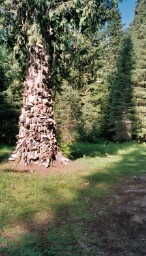
As you proceed along Road 1103, you will see primitive camp sites on your left. The Shoe Tree stands amidst the campsites. To my knowlege, this is the only Shoe Tree in the world.

Proceed along Road 1103 until it ends. Here you will find additional primitive campsites as well as the trailhead for Trail 261.

Trail 261 was in poor shape when I tried to hike it in 2002. I hear that trail crews opened it up to Trail 279 and then went on to Grassy Top Mountain in 2005, but not the portion of Trail 379 to High Rock Mountain.

I plan to hike this trail in 2006.

Note: Grassy Top Mountain can also be reached via
Trail 503 in the Sullivan Lake Ranger District.
Trail Marker on USFS Road 302 for Tillicum Creek Trail
Shoe Tree
Hosted by www.Geocities.ws

1