|
Map of Catanduanes |
Dugui Too Trek |
 |
Airial View of Virac |
|
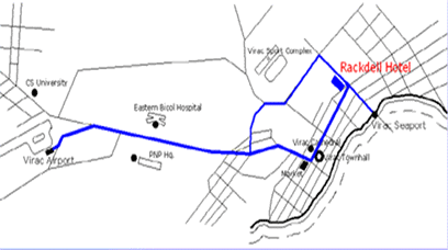
Location
Map
|
|
Map of Catanduanes |
Dugui Too Trek |
|
Airial View of Virac |
|
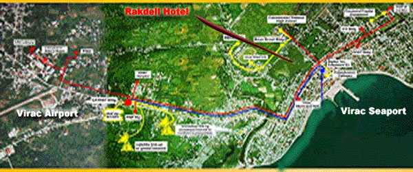
Location
Map
|
Copyright 2005. RakDell Hotel. All rights reserved. |Home| About Us | Contact Us || Site Map | Site Credits |news and events | http://www.rakdell.com.ph |
 |
Catanduanes on the East |
 |
Catanduanes from the Bicol Peninsula |
Catanduanes, an island paradise of howling winds and strange calm, lies east of the Bicol mainland. It is bounded on the west by the Maqueda Channel, by the Pacific Ocean on the north and east, and by Lagonoy Gulf and Cabugao Bay on the south. The island province has a total land area of 1,492.2 square kilometers. With Virac as its capital, Catanduanes is subdivided into 11 municipalities, 315 barangays and one congressional district. The population of the province as of May 1, 2000 was 215,356 reflecting a population density of 144.3 persons per square kilometer. The province has an average annual growth rate of 1.33 percent from 1995 to 2000. Due to its exposed location, Catanduanes is directly open to typhoons which had frequently visited it in the past immobilaizing its economy and its people. The province is rich in natural resources, forests, waterfalls, rivers, mineral deposits and productive soil made fertile by volcanic ashes of distant Mayon Volcano. Rattancraft, fishing, buri hat and mat making and abaca craft are its most important industries. Catanduanes tops other provinces in the production of the finest grade of abaca hemp. Catanduanes is famous for its unspoiled beaches, pre-historic caves, exotic places, quaint stone chapels and massive churches. Despite the typhoons, safe anchorage are provided by its many bays and coves notably Kalapalan, Gigmoto, Soboc and Cabugao. Its Pacific coastlines are havens for surfers. The province, formerly known as "Catanduan", "Catandongan", and finally Catanduanes, derived its name from the "tando" trees which then abound in the island. |