| Full Cascades Tour | Virtual Climbs | Live Cameras | Climb the Web | Top Pics | Climb Smart |
 |
 |
 |
 |
 |
Mt. Jefferson |
|
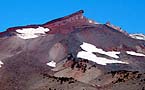
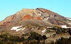
In general the climbing routes approach from the south, west, or north. The Warm Springs Indian Reservation covers much of the eastern flanks of the mountain which precludes camping or approaches from the east. However, there is still a wide variety of climbing routes that range from moderate to extreme difficulty including glaciers and steep rock. For advanced climbing parties in excellent condition, the ultimate challenge awaits in the form of the 400 foot summit pinnacle with technical rock pitches rated at 5.1 to 5.7. There is a lot of rotten rock on the pinnacle, so the best climbing conditions may exist during late winter or early spring when it is covered in snow and ice. Of course at this time of the year, just getting to the 10,000 foot elevation where the pinnacle begins is something of an expeditionary undertaking in itself. Even in summer high winds and low temperatures can be encountered at any time, so never underestimate the mountain no matter how nice the weather appears at lower elevations. The Pacific Crest Trail runs along the western flanks of the mountain passing through the Jefferson Wilderness and providing primary access to most climbing approaches. Some camp areas have experienced over use and are subject to access quotas. Check with the US Forest Service for details if you are planning a trip to the area. Highway 22 from Salem offers access to many of the trail heads leading to the northern, western, and southern routes. Availability of water can be affected by late summer conditions, although many small lakes and streams may offer potable water with proper purification. At higher elevations in late season water may be difficult to locate. From the north popular camp sites include Bays Lake, Scout Lake, Russell Lake and elsewhere in the Jefferson Park area. Over use may limit access to some of these areas. On the southern side of the mountain camps may be available at Pamelia Lake, Shale Lake, Hunts Lake, or Hanks Lake. Again, over use in some of these areas may limit access by the US Forest Service so check in advance when planning your trip. From the south you basically ascend several gullies east of Shale Lake via a very vague climbers route. You frequently must climb over or traverse around large rock formations and steep sections of rockly ridge line both ascending and descending along various sections of the climb. Cross pumice fields to gain the "Dragon's Back" black rock rib north of Goats Peak, and follow it up to the higher southern ridges. There is a fantastic minature forest of alpine dwarf pines contorted by the wind through this area. As you gain elevation the going can be slow in steep scree and cinder gravel. Stay left where ridges fall off toward the Waldo Glacier. Eventually as you approach 10,000 feet, bear right traversing upward around the steeper rocky ridgeline to arrive at Red Saddle. Many parties consider themselves successful to make it to this location on Jefferson. To climb the pinnacle, climb down west and then north traversing the west face of the stone tower. This is a steep angle traverse with huge exposure and a lot of rock fall! Rope and belay and helmets are recommended, especially if this face is frozen in snow or ice. Rock routes are described in Oregon High - A Climbing Guide. |
Logistics: Location: Climbing
Season: Maps: References: US
Forest Service Safety: Virtual
Climb: |
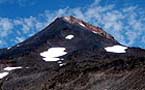
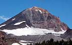
 Located
northwest of Bend, Oregon lies the second highest, but perhaps most
technically challenging alpine climb in the Oregon Cascades. At 10,497
feet in elevation, Mt. Jefferson is surmounted by a four hundred foot
rock pinnacle that turns many climbers back from the ultimate summit.
The remote location of the Jefferson Wilderness makes for true alpine
climbing since many routes to the summit cover ten to fifteen miles
or more, gaining as much as 7000 feet in elevation along some routes.
Mt. Jefferson is not an up and back in a day climb even if your goal
is just to make it to the base of the summit pinnacle.
Located
northwest of Bend, Oregon lies the second highest, but perhaps most
technically challenging alpine climb in the Oregon Cascades. At 10,497
feet in elevation, Mt. Jefferson is surmounted by a four hundred foot
rock pinnacle that turns many climbers back from the ultimate summit.
The remote location of the Jefferson Wilderness makes for true alpine
climbing since many routes to the summit cover ten to fifteen miles
or more, gaining as much as 7000 feet in elevation along some routes.
Mt. Jefferson is not an up and back in a day climb even if your goal
is just to make it to the base of the summit pinnacle.