|
The serene Lake Tahoe area was formed by seismic
shifting and landslides.

Lake Tahoe is the third deepest lake in North
America.
New data tells that significant seismic hazard
exists in the Lake Tahoe Basin from earthquakes,
ground shaking, faulting, landslides, liquefaction
of sediments and waves known as seiches.
|
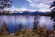
The
Geology of Lake Tahoe
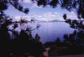
Lake Tahoe is
a popular place where most people go during
vacations. Its crystal clear waters and
characteristic blue color is unique from all lakes
that exist. The common misconception that people
have is that Tahoe was formed through volcanic
activity. It is only recently that the Tahoe Basin
is being mapped through a sonogram-which is a
device that works like an ultrasound in a pregnant
woman. Graham Kent, with the Scripps Institute of
Oceanography in San Diego, said that the Lake Tahoe
Basin was actually formed through a series of
faulting and landslides.
Lake Tahoe is
located in the California-Nevada border where
tectonic plates shearing past each other have
resulted in the Sierra Nevada (Irion, 2001). In
1999, geologists documented that two earthquakes,
with probable magnitudes of 7.2 and 7.5 struck
within the last 2000 years along a fault within
just 20 km east of the lake (Irion, 2001). New data
tells that significant seismic hazard exists in the
Lake Tahoe Basin from earthquakes, ground shaking,
faulting, landslides, liquefaction of sediments and
seismic waves known as seiches (Irion,
2001).
New data about
the basin can be seen in the Nevada
News.
The basin was
formed through faulting, a process in which the
earth's crust allows blocks of land to rise and
sink. Several thousands of years ago, the Sierra
Nevada Mountains were rising from the sea. Two
principal faults were formed-the Carson Range on
the eastern range and the Sierra Nevada mountains
on the western side (Edson, 2001). Geologically
speaking, this is a recent land development,
occurring only these past few million years. One of
the reasons for the movement of the fault is magma
(Edson, 2001). Magma generates a whole lot of
pressure and heat.
Facts:
|
|
1.
Lake Tahoe is the third deepest lake in
North America and the tenth deepest lake
in the world.
2.
Two-thirds of the lake is in the state of
California and one-third of it is in the
state of Nevada.
3.
Its surface elevation is 6225 feet above
sea level, making it the highest lake of
its size in the United States.
|
VISIT:
www.tahoecam.com/TahoeFacts.html
for more facts and information.
Just a few
years back, the lake was so clear that objects
could be seen up to the depths of 120 feet. However
in the last three decades, more than thirty feet of
visibility have been lost. Because of the lake's
popularity, the population has increased. With this
increase, pollution, of both water and air caused
sediments to wash down the lake. The sediments
contain nutrients which affect the water's
ecosystem and clarity. Construction of roads and
cars using these roads causes loose dirt to drift
in the lake.
--by
Margarita Montes
�
�
�
�
|
�
|