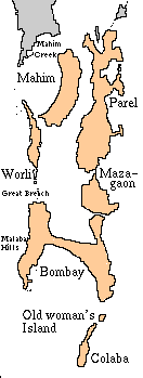
Proceeding roughly south to north, the seven islands ceded by the Portuguese to the British were Colaba: whose name is a corruption of the Koli name Kolbhat. Old Woman's Island: (alternatively, Old Man's Island) a small rock between Colaba and Bombay, whose name is a corruption of the Arabic name Al-Omani, after the deep-sea fishermen who ranged up to the Gulf of Oman. Bombay:
The main harbour and the nucleus of the British fort from which the modern city grew; it stretched from Dongri on the east to Malabar Hill on the west. Mazagaon: a Koli settlement to the east of Bombay island was seperated from it by Umarkhadi and Pydhonie. Worli: north of Bombay was seperated from it by the Great Breach, which extended westwards almost to Dongri. Parel:
North of Mazagaon and called by many other names, including Matunga, Dharavi and Sion. The original population was predominantly Koli. Mahim: to the west of Parel and north of Worli, took its name from the Mahim river and was the capital of a 13th century kingdom founded by Raja Bhimdev
|