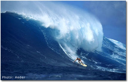
Beginning on Tuesday, August 5th, the California and Baja coasts were rocked by the swell from Hurricane Guillermo. Guillermo formed off the tip of Baja and quickly went to category 5 the most powerful storm off the Pacific coast in years. The swell lasted for over a week, and provided the U.S. Open in Huntington Beach with some of the biggest California contest surf ever some waves reaching triple-overhead. Even Tom Curren termed it "scary". We called Surfline Meteorologist Chris Borg to find out why the storm was so strong and what's in store for the rest of the season.
Why was Hurricane Guillermo so big, and did El Ni�o have anything to do with it?
Yes. El Ni�o warmed waters that allowed Guillermo to get so big, and there was also the upper-level airflow, which was favorable. The two combined for a Category 5 hurricane (a Category 5 hurricane is a storm with sustained maximum winds of at least 135-140 knots).
How warm was the water where the hurricane formed, and what would the water temperature normally be in a non-El Ni�o year?
I believe it was in the upper-80s, and I think you can take away about four or five degrees (F�) from that normally.
Does it look like there's potential for other storms this size to form in the Pacific Ocean this summer, or did Guillermo churn up so much water that it may have cooled it off a little bit?
Well, that's always the case for the first couple of days after one of those passes through, but it'll settle back down again. We'll have the potential again after that.
So the patterns are looking fairly favorable for another Guillermo?
Right. There's nothing going on right now, but that could turn around at any time.
With the way that the El Ni�o is shaping up right now, is it still looking like it's a really strong El Ni�o this year compared to others that you've seen?
Yes. People have been comparing it to the `82-'83 winter, so I think that's a reasonable comparison.
Assuming it is, when will the West Coast start to see storms forming because of this El Ni�o?
I'd say it would probably start in late November and early December. We'll start to get the rain, and then the storms should be pretty heavy.
Will this El Ni�o make a difference in the strength of the storms which form in the Aleutians, giving us the big northwest swells?
Yeah. What it'll do is bring them down farther, so actually Washington and northern Oregon are expected to go drier than normal and have mild weather, whereas those storms that usually would be going into them are going to be heading further down the coastheading our way, so we'll have a wetter-than-normal winter.
Which is good news to skier, surfers, snowboarders, etc.
Exactly.
Does El Ni�o have any tendency to increase or decrease the severity of Santa Ana conditions that we might get in the fall?
I've heard mixed reviews about that. I don't believe that it does increase them, but I'm not sure. I've heard people say that it does.
In terms of the East Coast, it's been a very slow summer for them thus far. Is there any hope for them later in the summer, and has El Ni�o affected the fact that there hasn't been much tropical formation?
Yeah, it slows them down. It definitely is a monkey wrench in there for tropical stuff. As a result, they've had a slow season so far, and that's not doing it any better. I'm sure that Dr. Gray has downgraded his number of storms that he already predicted this season, and I wouldn't be too surprised if he downgrades it again. (Dr. William Gray is a Colorado State University meteorologist who is known for his yearly hurricane predictions) There's really not much going on out there now, and it really doesn't look like there's a whole lot of improvement in sight.
So maybe the best advice to East Coasters is get out to California.
Yep. Travel.

 Back to Surf Home