
The drawing of the log church from Howard Morse's book, "Historic Old Rhinebeck," indicates that a log church was located on this site. The Lutheran and Reformed congregations shared the structure until 1729 when the Lutherans acquired land, north on the King's Highway and built a church where the Old Stone Church is now located. Sometime later, the Reformed congregation may have built a structure, replacing the log church. A circa 1750 map shows a frame structure with a bell tower. The Alexander Thompson 1798 map of Rhinebeck at the Starr Library shows a bell tower at the front, similar to Stone Church. This may be the structure which was damaged by a wind storm and taken down when the Reformed congregation decided to move to Red Hook and dismantled the building before 1802. The congregation in Red Hook eventually became the St. Paul's Lutheran Church of Red Hook.
Drawing shows c.1716 log church which stood at the front of the
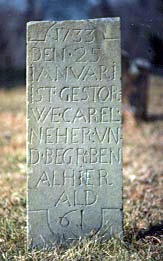
Tombstone of Carl Neher who
old Rhynbeck cemetery. This is possibly the first church built in
died in 1733. Stone, carved in
Dutchess County. It served Palatine Lutheran and Reformed congregations.
German is near the
Lutheran church

Detail of the Reformed Church at this
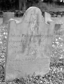
John Pottenburg, Revolutionary War soldier,
location from c.1750 Map
buried in the Old Rhynbeck cemetery.