 |
 |
| Teotihuacan |
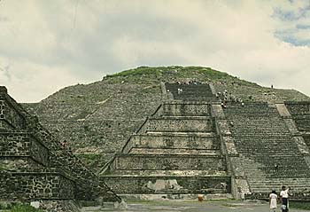
| Pyramid of the Sun |
| Pyramid of the Moon |
| The Sun Pyramid was extensively excavated in the first decade of this century by Leopordo Batres. Since that time, two tunnels have been excavated into the core of the pyramid, providing more information about its chronology and substructure. Another extensive excavation by INAH, directed by Eduardo Matos Moctezuma in 1992-93, exposed more of the pyramid complex, especially on its north and east sides. As originally built, the Sun Pyramid was approximately 215 by 215 m at the base, and about 63 m high. It was significantly enlarged at least twice in later periods, resulting in a final size of 225 m along each side. The pyramid was located on the east side of the Avenue of the Dead in the northern half of the city. If the area of monumental construction between the Moon Pyramid and the San Juan Canal is regarded as the central zone of the city, the Sun Pyramid is located at its middle. In addition to its geographic centrality, the importance of the pyramid is indicated by a cave located under the structure. |
| These pages about the Feathered Serpent Pyramid, Teotihuacan, Mexico, have been designed for students, scholars and the general public. The information used here is provided by an international archaeological research project focused on the Feathered Serpent Pyramid at Teotihuacan. The documents complement hard-copy publications in Spanish and English which are currently being prepared by the same project. In addition to summarizing material included in these publications, these pages also contain information which the hard-copies do not. One of the main goals of this project is to provide a means by which new data about the Feathered Serpent Pyramid and Teotihuacan can be presented and regularly updated. We hope that information and interpretations encountered in these pages will promote discussion and encourage the exchange of new insights and perspectives that will further interdisciplinary projects in Mesoamerican culture and history. The pages are organized hierarchically, as shown in the table of contents below. The general index map attached to the bottom of each page can be used to move rapidly to the head page in each category. Previous and Next buttons are useful for those who want to read the pages in hierarchical order. Most of the photos, maps, and plans that accompany the texts have a large version for those who want to examine them in more detail. Just click on them to get larger version. We plan to expand these pages in a variety of ways in the near future. The pages currently available are experimental; some are still under construction and/or may be replaced with expanded versions. Please revisit us in the future for new and updated versions. |
| Pyramid of Quetzalcoatl |
| The Pyramid of the Moon is located at the extreme northern end of the Avenue of the Dead, the principal axis of the city of Teotihuacan. The pyramid, facing towards the south, was constructed as the principal monument of the Plaza of the Moon. For many years it was believed that the pyramid contained earlier structures within its walls, but until the Pyramid of the Moon Project excavations began in 1998, archaeologists could only guess at how many there were and how they had been constructed. Over the last four years, as a result of the fieldwork that has been carried out, a large quantity of information and materials have been obtained. All of these materials are now in the process of being analyzed. The team plans to continue the excavations of the Pyramid of the Moon and the adjacent areas over the next few years. A brief summary of what has been accomplished to date, along with the preliminary results of the analyses, is presented on the following pages. |
| Teotihuacan arose as a new religious center in the Mexican Highland, around the time of Christ. Although its incipient period (the first two centuries B.C.) is poorly understood, archaeological data show that the next two centuries (Tzacualli to Miccaotli phases; A.D. 1-200) were characterized by monumental construction, during which Teotihuacan quickly became the largest and most populous urban center in the New World. By this time, the city already appears to have expanded to approximately 20 square km, with about 60,000 to 80,000 inhabitants (Millon 1981:221). The development of the city seems to have involved inter-site population movements, exploitation of natural resources, an increase in agricultural production, technological inventions, establishment of trading systems and other kinds of socio-political organizations, and attractive belief systems. By the fourth century, unmistakable influences of Teotihuacan were felt throughout most parts of Mesoamerica. , you may want to visit other major monuments placing the pyramid in the wider context of the city. |
 |
 |
 |
 |
| Teotihuacan was the sixth largest city in the world during its period of greatest prosperity, according to an estimated population of 125,000 (Millon 1993:33). The city seems to have functioned for centuries as a well-developed urban center until its rather sudden collapse, possibly in the seventh century. The place was called Teotihuacan by Nahuatl speakers several centuries after the city's fall, but its original name, the language or languages spoken there, and the ethnic groups who built the city are still unknown. Many surveys, excavations, and studies of materials have been made for more than a century, employing different kinds of approaches and techniques. Since the first scientific inter-disciplinary investigation was carried out by Manuel Gamio in 1917-22, several explorations have revealed specific cultural traits and helped situate Teotihuacan prehistory within the Mesoamerican chronological framework. The Teotihuacan Mapping Project (Millon 1973; Millon et al. 1973) directed by Rene Millon contributed substantially to forming current views of the city. The Settlement Survey Project in the Basin of Mexico, directed by William Sanders, placed Teotihuacan in a regional context (Sanders, Parsons, and Santley 1979). Various explorations in the 1960s and 1970s in residential compounds in the city provided information about social life and categories. Meanwhile, monumental constructions were excavated by Mexican archaeologists from national institutions, most recently the Instituto Nacional de Antropologia e Historia (INAH), since the beginning of this century. Most of buildings now seen in the Archaeological Zone in Teotihuacan were actually those excavated and consolidated by these national projects. The Feathered Serpent Pyramid was among these, first excavated in 1917-22. Before concentrating on the Feathered Serpent Pyramid, you may want to visit other major monuments placing the pyramid in the wider context of the city. |
| It is believed by certain scholars that the cave was used for ritual activities, and why the pyramid was constructed where it is today. The pyramid was actually reconstructed as five stepped platforms. However, the forth platform seems to have been erorneously reconstructed by Batres early this century. The pyramid originally consisted of four stepped platforms, a surmounting temple, and the Adosada platform, which was built over what was originally the principal facade of the pyramid. No information about the temple itself is available, since, along with the upper-most portion of the pyramid, it has been completely destroyed. |
| 1/3 |
| 1/3 |