
|
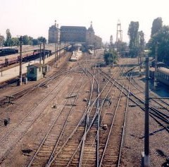
Inspired by Steve Little's trip to Walton Hall, Proches Ngutini, a recent visitor to Milton Keynes took a similar trip from Temboni to OUT (along Morogoro road) by car. The road runs from Temboni east towards city centre, all the way to the passenger terminal of the harbours ending at its junction with Sokoine Drive which takes you to Kivukoni ferry. Proches picked this road not because his home is in that direction but because this is the busiest route out of the city. All busses and lorries to the north, north east, north west, west, central, and south west and to neighbouring countries use this outlet/inlet. The only other route there is the route to south (Mtwara and Lindi). Because of the physical geography of the city - full of creeks and rivers running towards the city and to the ocean, all traffic to the airport, harbour, industrial estate and Bagamoyo, tourist hotels on the coast, all bus and railway terminal must pass through this up to Ubungo after which they can branch off to relevant directions. So it is an important economic and social infrastructure worth studying. Please read on to see Proches' photographs and descriptions. One problem that Proches faced was Internet speed. As a result he had to resize and compress his images for web publishing - used Microsoft picture manager. |
|
|
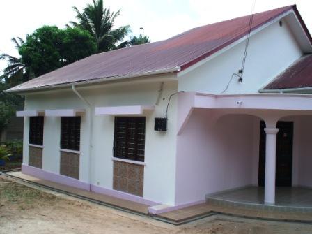
Picture 1: Proches's home at Temboni about 23 kms drive from the city centre along the T1 road from Dar es Salaam to Chalinze. (see Dar es Salaam regional road network map and the Tanzania trunk road network) |
|
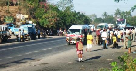
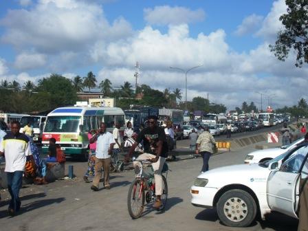
Picture 2: Bus stop at Temboni. Here we see a number of things. First, Public transport is provided by small busses (between 16- and 35-seater mini busses). The bigger bus at the back is an inter-city bus. Secondly, this is a cross junction on a busy road one of the most notorious points on this road. Behaviour of users contributes to it. You will notice here that the mini busses are not parked at the actual bus stop (see about where the girl with a back pack is standing). Passengers do not stand at the buss stop either but at the junction. While drivers would argue that they have to stop where the passengers are (shifting the blame to passengers), passengers would argue that they have to stand up road to increase their chances of getting on the bus first. But also passengers prefer to stand right at the junction to increase the changes of getting a lift from private motorists feeding into the highway (see for example there is a vehicle about to enter the highway on the far right of the photo). Thirdly, you see the trucks on the other side of the road almost completely blocked access from the other feeder road. Fourth, for motorist getting off the highway to the right feeder road have no safety patch on which they can wait for their turn. This cause long queues and is very dangerous especially during the rush hours (mornings and evenings as well as during the early night). Also because of the passenger and driver behaviour, visibility is impaired when you are entering the highway from the feeder road. Note: The direction of the minibuses is to the city and the opposite direction is to Chalinze and up-country. My house is about 600 metres from this bus stop on the right hand side. |
|
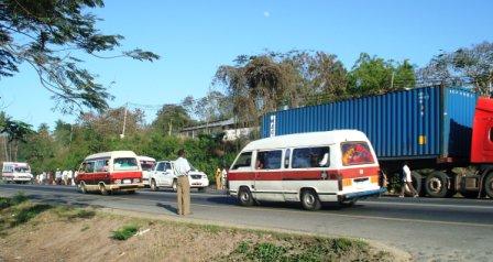 |
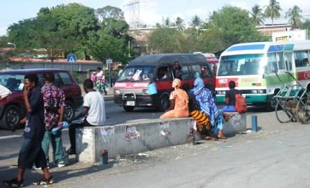
Picture 3: A container truck is parked at the bus stop (second from Temboni) possibly overnight. As a result, public transport busses find it difficult to pool out of the road properly to drop and pick passengers (see for example, at the far left where passengers had to move to where the driver could pool out, away from the designated bust stop. To make matters worse, this bust stop is located on a left bend making visibility beyond cars at the front difficult and overtaking is prohibited. Thus is a bus is in front of you and it stops you must wait until it moves. Because of impatience and time factors some drivers do overtake making this stop a "leader" in road accidents in the area. There are several schools around as well as churches including our local RC church and Assemblies of God. It is also a cross road junction leading to populated settlements both sides of the road. It is a busy crossing without any pedestrian crossing and signs. In October last year (2006) I did hit a 12 year old girl (at 30 kms/hr) coming from the church in the evening, luckily she survived. |
|
Picture 4: At the same bus stop just as I got here there was an accident. See the greenish double cabin track and a similar truck behind it that had hit the former from behind, causing other motorists to negotiate their way through the left hand side; overtaking over the right hand side is dangerous because of the road bend which makes visibility difficult. Since the response rate of Traffic police and rescue services can be slow, these cars take time before they are cleared out of the road. In most cases, the drivers enter into a "gentleman's agreement" on how to compensate each other and clear off. Otherwise if they depend on an insurance claim, they will have to wait for the relevant authorities and that causes a lot of problems to other motorists and loss of valuable time to those involved and other users of the road. |
|
|
|
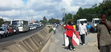
Picture 5 represents the most nightmarish stretch of this road: a stretch between Kibo and Ubungo just before entering the second ring road of the city. The stretch slopes gently over a stretch of about 600 metres, and it claimed a number of lives and property to accidents, mainly due to mechanical failures or long distance drivers falling asleep on the wheel as the trail slowly on the jam. Traffic trail used to be held up 2 kms long behind this stretch, and some impatient drivers would use the pedestrian/service lane to cut the queue and join the road again further down the hill, hence blocking the flow and both they and the patient one fight for their first right of way. Last Christmas (on the 19th December 2006) I was on the jam about a km behind this and a lorry failed and hit 7 cars including mine at the middle of it. My car was severely damaged but I was luck to escape unhurt. See the following pictures for more details about the area. |
|
Picture 5.1 shows the bottom of the stretch in Picture 5. It is a busy bus stop christened "Ubungo maji" (maji is a Swahili work for water) because the stop is at the front of Ministry of Water and there is a huge water storage and distribution reservoir. As the photograph shows, (see the remains of the steel supports) it was shaded but the shade was completely destroyed by failing motors taking a number of lives away with them (passengers waiting for transport at the bus stop and also there is a very busy pedestrian crossing). Also look at the way the iron bars were chopped off making them very dangerous for pedestrians. Don't forget the push cart also parked unattended. |
|
|
|
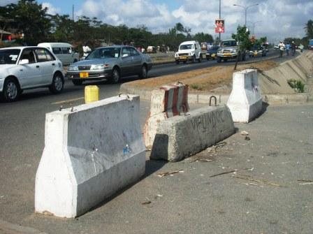
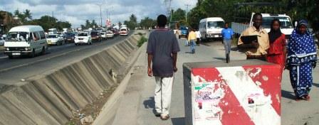
Picture 5.2: To curb the motorists' behaviour of using pedestrian/service lane during rush hours huge concrete blocks are placed to block the way . This helps the flow and order of traffic on the road a lot. |
|
Picture 5.3: Again to block those who still find ways through from joining back the main road several blocks are placed at the exit/entrance . On the other hand these measures have always made it very difficult to evacuate the road during major accidents at this area. Several cars would be crashed into the drainage trench and because most of the time heavily loaded lorries are involved, there are heavy casualties and to evacuate, ambulance services, breakdown service including lifting cranes must be brought in. These heavy blocks become a problem in terms of the provision of quick emergency support on site while waiting for formal/professional support. |
|
|
|
Picture 5.4: Despite these measures, some still manage to squeeze their cars on the reserve strip beyond the yellow line (see the minibus on the right). |
|
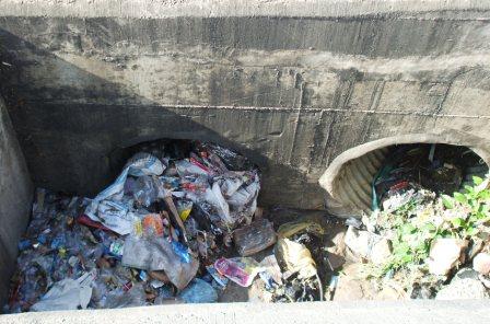
Picture 5.5: During the heavy rain seasons there is another problem in the area - flooding. Although there is drainage facility, these are blocked by rubbish created by disposal behaviour. See rubbish (mainly plastic packaging materials, polythene bags etc) that has completely blocked the drainage. |
|

 |
 |
 |
 |
This page last updated 04 November 2007
This page is maintained by
Stephen
Little
Head, Centre for Innovation, Knowledge and Enterprise
Open
University Business School
Milton Keynes, U.K.
[email protected]