Home
| Cahir | Kinsale
| Crookhaven
| Crookhaven
| Sneem |
Sneem | Dingle
| Dingle |
Doolin | Oranmore
| Boyle | Carrick
on Shannon | Roosky
| Lanesborough
| Lanesborough
| Shannonbridge
| Banagher
| Bunratty
| Map
Sunday, May 11
 We
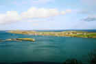
woke up to threatening weather. It rained, then stopped, and then rained again.
This was to be a regular for the trip. The unsettled moisture was reinforced
with roaring winds. Over breakfast, we all made plans for the day. We decided
that the rain looked restless for a while, so we would head over to Sheepshead
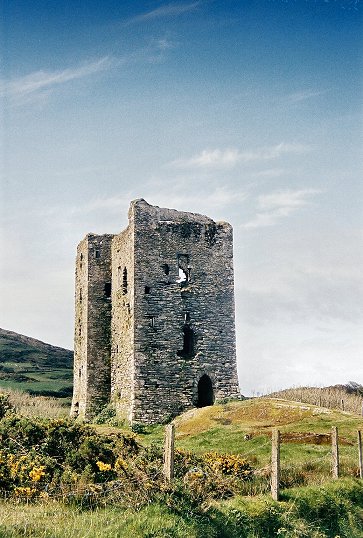
Peninsula and drive around a bit. We followed the road to Durrus and stopped
along the way at one of the countless ruined castle towers and then along the
south coast of Sheepshead. The drive here is an often overlooked, yet beautiful
and well worth it. The Mizen coast is across the bay, and the area is not very
crowded. This peninsula seems to lead Ireland in property for sale.
We
woke up to threatening weather. It rained, then stopped, and then rained again.
This was to be a regular for the trip. The unsettled moisture was reinforced
with roaring winds. Over breakfast, we all made plans for the day. We decided
that the rain looked restless for a while, so we would head over to Sheepshead
Peninsula and drive around a bit. We followed the road to Durrus and stopped
along the way at one of the countless ruined castle towers and then along the
south coast of Sheepshead. The drive here is an often overlooked, yet beautiful
and well worth it. The Mizen coast is across the bay, and the area is not very
crowded. This peninsula seems to lead Ireland in property for sale.
 As
you head towards the tip, the road continuously narrows. Near the end, it is
just a bit wider than one car and the driver need to watch for oncoming traffic.
It was a relief to have everybody in one car for the first time. There is a
parking area and then the hike starts. I have made it to the tip before, but
today was not as promising. We all threw on some rain gear, but I didn’t grab
the rain pants. This proved to be an error. Shortly after our walk started, the
rain started. Millie and Felicity turned back immediately and Bill and I decided
to walk to the crest to see if the storm appeared to be a short one. As we
reached the crest the light mist turned to a savage pelting of wind and hail.
This would be enough for us and we turned around and headed back. The tail wind
was strong enough and the rain and hail hard enough to give me my first soaking
of many to follow. Bill had made the turn a bit earlier than me and I was taking
up the rear as the water saturated my formerly comfortable and dry Dockers. Ah,
rain pants … that would have been a good idea.
As
you head towards the tip, the road continuously narrows. Near the end, it is
just a bit wider than one car and the driver need to watch for oncoming traffic.
It was a relief to have everybody in one car for the first time. There is a
parking area and then the hike starts. I have made it to the tip before, but
today was not as promising. We all threw on some rain gear, but I didn’t grab
the rain pants. This proved to be an error. Shortly after our walk started, the
rain started. Millie and Felicity turned back immediately and Bill and I decided
to walk to the crest to see if the storm appeared to be a short one. As we
reached the crest the light mist turned to a savage pelting of wind and hail.
This would be enough for us and we turned around and headed back. The tail wind
was strong enough and the rain and hail hard enough to give me my first soaking
of many to follow. Bill had made the turn a bit earlier than me and I was taking
up the rear as the water saturated my formerly comfortable and dry Dockers. Ah,
rain pants … that would have been a good idea.
The
rain began to lessen just as I made it back to the parking lot and as it quit I
tried to make use of the natural resource of the wind as a dryer. No chance of
this working. The amount of water in my pants had reached maximum density and
there was no way a mere gale force wind was going to dry them out quickly. I
returned to the car and squished into the drivers seat. It should be noted, that
anything that causes me discomfort, causes Felicity convulsions of
uncontrollable laughter. This was no exception. I’m quite certain a gunshot
wound to any part of my body would be the end of her as her heart could not take
the pressure of the resultant hilarity.
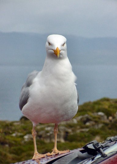
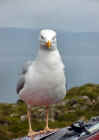 Those
of us who had set out earlier had all returned to our cars and others were just
arriving, confident that the weather gods were going to smile on them. The
couple in the car next to us had decided to grab a bite to eat and fortunately
did so in the safety of their vehicle. You see, it seems that rabid, killer
gulls reside in the area and they expect to be fed. One of them lit on the car
and with a hungry look, suggested that the food be shared. The occupants did not
comply. The bird then pecked a bit on the windshield. Still no sharing from
within. So, in an angry attempt to make a point, the frustrated gull started
ripping at the windshield wiper, snapping it on the windshield with a violent
fervor. Inside the terrified diners grabbed their cameras, no doubt in a attempt
to document the violence that was being perpetrated upon them and their innocent
vehicle. They were not about to give in to bully gulls that go around picking on
the weak kids and trying to steal their lunch.
Those
of us who had set out earlier had all returned to our cars and others were just
arriving, confident that the weather gods were going to smile on them. The
couple in the car next to us had decided to grab a bite to eat and fortunately
did so in the safety of their vehicle. You see, it seems that rabid, killer
gulls reside in the area and they expect to be fed. One of them lit on the car
and with a hungry look, suggested that the food be shared. The occupants did not
comply. The bird then pecked a bit on the windshield. Still no sharing from
within. So, in an angry attempt to make a point, the frustrated gull started
ripping at the windshield wiper, snapping it on the windshield with a violent
fervor. Inside the terrified diners grabbed their cameras, no doubt in a attempt
to document the violence that was being perpetrated upon them and their innocent
vehicle. They were not about to give in to bully gulls that go around picking on
the weak kids and trying to steal their lunch.
Though
the skies had cleared, we were aware that the weather could and would change in
seconds and my associates decided that a 1.5 hour hike would not be wise, so we
headed off, I with a mildewing seat to support me, in search of new adventure.
The peninsula has some convenient maps
as you drive it with a few “You are here” points to help out. On my last
trip, I had missed the road on the opposite coast and I thought I would try to
find it. The Michelin map is not complete enough here and finding the road is
not easy. The Ordinance Survey map (which I purchased the next day) is complete
enough. None-the-less, with the use of the “you are here” maps, we found our
way to the north coast of the peninsula. The road winds back towards the tip and
you are sure you are on the wrong road. As the road climbs, it naturally narrows
and you eventually reach the spine on this long finger of land. Bantry Bay
appears in front of you and you wonder why Michelin didn’t call this a scenic
route. Perhaps the locals paid them off. There is another reason though. By this
point, t he
pathway is part pavement, part grass. Occasionally signs marking the Sheepshead
Way trail show up beside the road. We stopped at one vista and looking up the
hill, we saw signs for the trail, but absolutely no sign of a trail. It is a
hearty soul that hikes this trail, and we didn’t see any that day. The road
itself made for a beautiful path and we didn’t meet another car for miles.
This was fortunate. It was also miles before we made it out of second gear, and
first was the norm.
he
pathway is part pavement, part grass. Occasionally signs marking the Sheepshead
Way trail show up beside the road. We stopped at one vista and looking up the
hill, we saw signs for the trail, but absolutely no sign of a trail. It is a
hearty soul that hikes this trail, and we didn’t see any that day. The road
itself made for a beautiful path and we didn’t meet another car for miles.
This was fortunate. It was also miles before we made it out of second gear, and
first was the norm.
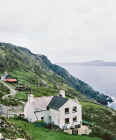
We were compelled to think of the lives of the people
here and wonder what it must be like. Clearly, they must be pretty self
sufficient and very good planners. The drive to any amount of civilization would
be lengthy and there’s no “Oop’s, I forgot to buy butter”.
We wondered who delivered their furniture. Mostly though, we admired what
must be a wonderful, peaceful existence in a countryside that is blanketed in
character and a scenery that is as changeable as the breeze.
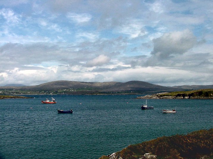
The
beautiful Beara Peninsula was across the bay and we headed towards civilization
and perhaps a bite to eat. We were not part of a group of crazed hooligans who
demanded food by violently tugging on windshield wipers, so we would have to pay
for our meal at a restaurant.
As
we approached Bantry, the strange site of a Ferris wheel loomed before us. We
had apparently arrived at the peak of the Mussel Festival and the good times
were in full swing. Parking was an enormous problem but we found a space at the
top of the hill and got out to look for some grub. The mussel festival not only
has rides, but live music and as we approached the sound stage, the sounds of
traditional Irish salsa music came blasting our way. A female vocalist, a bevy
of percussionists and a wall of brass instruments greeted our entry to
restaurant row in Bantry.
Most
of the restaurants were packed and getting a seat was a challenge, but we found
a place, waited for a  confused
staff to explain to an even more confused clientele of tourists that we would be
seated eventually. Mussels were being served up like M&Ms and consumed at
the same speed. None of us went that route, though I had some fish and chips and
yes, a bit of stout
confused
staff to explain to an even more confused clientele of tourists that we would be
seated eventually. Mussels were being served up like M&Ms and consumed at
the same speed. None of us went that route, though I had some fish and chips and
yes, a bit of stout
As
Felicity and Millie shopped, Bill and I sought liquor for the evening. They
wanted Bailey’s and lots of it. Well, it turns out that it is impossible to
find Bailey’s in Bantry on a Sunday afternoon. They would have to be content
with wine.
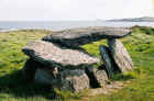 As
we left Bantry, we passed an enormously long string of cars, curved along the
coastline, waiting to look for parking and settle into the final night of the
mussel festival. It was a good time to be going the other way. The road back to
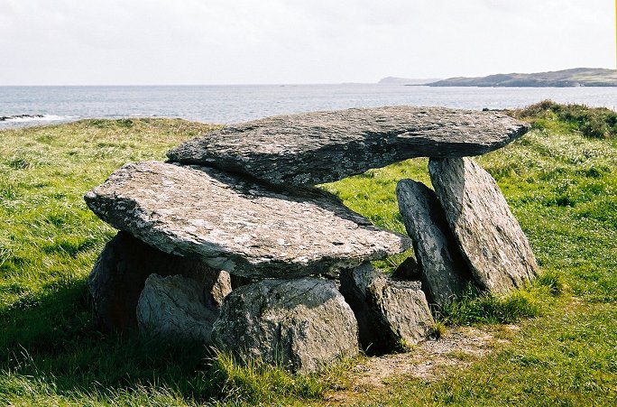
Crookhaven through Goleen is a fine drive and just north of Goleen is an
interesting dolmen. It is hard to see as you approach from the north, but when
we passed it, we knew it and went back to catch it.
As
we left Bantry, we passed an enormously long string of cars, curved along the
coastline, waiting to look for parking and settle into the final night of the
mussel festival. It was a good time to be going the other way. The road back to
Crookhaven through Goleen is a fine drive and just north of Goleen is an
interesting dolmen. It is hard to see as you approach from the north, but when
we passed it, we knew it and went back to catch it.
 I
was dying to take some pictures without the worry of slowing people down, so I
dropped everyone off at the B&B and prepared to make a little trip on my
own.
I
was dying to take some pictures without the worry of slowing people down, so I
dropped everyone off at the B&B and prepared to make a little trip on my
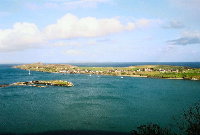
own. 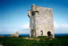 Felicity decided to join me. We followed the road along Crookhaven Bay and
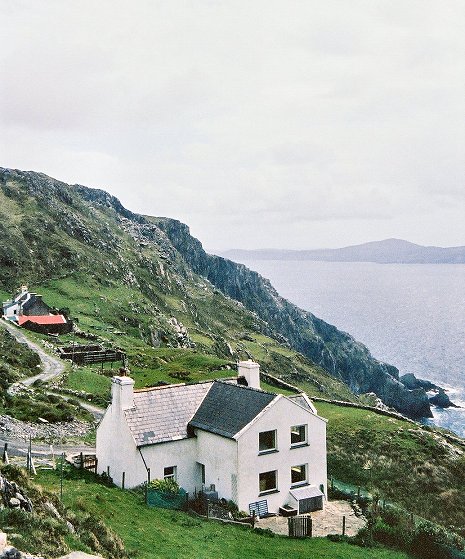
then found a road that climbed up the hill opposite the town of Crookhaven. Once
again, just wide enough for one car, it serviced a couple of homes on the side
of the hill. As we rose, we could see the tiny peninsula that Crookhaven
slumbered on and over that to the ocean beyond with Fastnet lighthouse in the
distance. The road wound around and eventually took us back in to Goleen so we
hurried back to Crookhaven. OK, not quite. Just as you round the bend towards
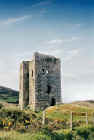
the village, a road climbs the hill to the top of Brow Head and old watchtower
remains. The views from here are incredible and I lingered longer than I should.
The tower is just up the hill from the end of the road. The turf here is an amazing
texture, an extremely thick carpet of grass that sinks beneath your feet like a
soft mattress. The cliffs towards Crookhaven are beautiful and sprawl in front
of you as you descend the road back to Crookhaven.
Felicity decided to join me. We followed the road along Crookhaven Bay and
then found a road that climbed up the hill opposite the town of Crookhaven. Once
again, just wide enough for one car, it serviced a couple of homes on the side
of the hill. As we rose, we could see the tiny peninsula that Crookhaven
slumbered on and over that to the ocean beyond with Fastnet lighthouse in the
distance. The road wound around and eventually took us back in to Goleen so we
hurried back to Crookhaven. OK, not quite. Just as you round the bend towards
the village, a road climbs the hill to the top of Brow Head and old watchtower
remains. The views from here are incredible and I lingered longer than I should.
The tower is just up the hill from the end of the road. The turf here is an amazing
texture, an extremely thick carpet of grass that sinks beneath your feet like a
soft mattress. The cliffs towards Crookhaven are beautiful and sprawl in front
of you as you descend the road back to Crookhaven.
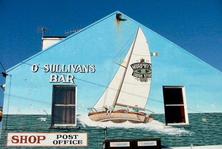
 Sadly, one of our goals on
this trip was not to be accomplished. Billy O’Sullivan had been at the funeral
of a sister-in-law and was then off to France for some golf. Rose was not to be
found on Sunday evening. We had eaten dinner at the Crookhaven Inn again and
went to O’Sullivan’s for drinks after. We talked with Billy’s son a bit
and admired the clientele as we sat by the peat fire. This is a fisherman’s
pub. They came here to drink and tell tales and wile away the night. A mix of
Gaelic and English filled the room, but mainly it was laughter. I don’t know
if it had been a good day fishing, but it was certainly a good night drinking.
Sadly, one of our goals on
this trip was not to be accomplished. Billy O’Sullivan had been at the funeral
of a sister-in-law and was then off to France for some golf. Rose was not to be
found on Sunday evening. We had eaten dinner at the Crookhaven Inn again and
went to O’Sullivan’s for drinks after. We talked with Billy’s son a bit
and admired the clientele as we sat by the peat fire. This is a fisherman’s
pub. They came here to drink and tell tales and wile away the night. A mix of
Gaelic and English filled the room, but mainly it was laughter. I don’t know
if it had been a good day fishing, but it was certainly a good night drinking.
More
Pictures
| Home
| Cahir | Kinsale
| Crookhaven
| Crookhaven
| Sneem |
Sneem | Dingle
| Dingle |
Doolin | Oranmore
| Boyle | Carrick
on Shannon | Roosky
| Lanesborough
| Lanesborough
| Shannonbridge
| Banagher
| Bunratty
| Map
|
 We
woke up to threatening weather. It rained, then stopped, and then rained again.
This was to be a regular for the trip. The unsettled moisture was reinforced
with roaring winds. Over breakfast, we all made plans for the day. We decided
that the rain looked restless for a while, so we would head over to Sheepshead
Peninsula and drive around a bit. We followed the road to Durrus and stopped
along the way at one of the countless ruined castle towers and then along the
south coast of Sheepshead. The drive here is an often overlooked, yet beautiful
and well worth it. The Mizen coast is across the bay, and the area is not very
crowded. This peninsula seems to lead Ireland in property for sale.
We
woke up to threatening weather. It rained, then stopped, and then rained again.
This was to be a regular for the trip. The unsettled moisture was reinforced
with roaring winds. Over breakfast, we all made plans for the day. We decided
that the rain looked restless for a while, so we would head over to Sheepshead
Peninsula and drive around a bit. We followed the road to Durrus and stopped
along the way at one of the countless ruined castle towers and then along the
south coast of Sheepshead. The drive here is an often overlooked, yet beautiful
and well worth it. The Mizen coast is across the bay, and the area is not very
crowded. This peninsula seems to lead Ireland in property for sale.