Home
| Cahir | Kinsale
| Crookhaven
| Crookhaven
| Sneem |
Sneem | Dingle
| Dingle |
Doolin | Oranmore
| Boyle | Carrick
on Shannon | Roosky
| Lanesborough
| Lanesborough
| Shannonbridge
| Banagher
| Bunratty
| Map
Saturday, May 10
 We
left the Cephas house to find our way to Charles
Fort, lost Millie and Bill, missed the turn, had to get turned around,
passed them going the other way, they missed the turn ...blah, blah, blah.
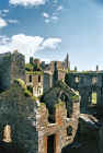
Kinsale is a busy town, even on a Saturday morning. We eventually found the
place. This is quite a remarkable building, and we got there early and had the
place almost all to ourselves. The views out to the harbor are awe-inspiring.
There was an Irish military ship stationed in the bay, which was in stark
contrast to the old stone fort. You have to figure that not only did the
designers realize the strategic importance of the site, but also must have said
“Nice view, let’s build a fort”. It’s easy to wander around the sight
and get lost or lose your travel companions, and I managed to do both. I
finally found them and myself back at the car.
We
left the Cephas house to find our way to Charles
Fort, lost Millie and Bill, missed the turn, had to get turned around,
passed them going the other way, they missed the turn ...blah, blah, blah.
Kinsale is a busy town, even on a Saturday morning. We eventually found the
place. This is quite a remarkable building, and we got there early and had the
place almost all to ourselves. The views out to the harbor are awe-inspiring.
There was an Irish military ship stationed in the bay, which was in stark
contrast to the old stone fort. You have to figure that not only did the
designers realize the strategic importance of the site, but also must have said
“Nice view, let’s build a fort”. It’s easy to wander around the sight
and get lost or lose your travel companions, and I managed to do both. I
finally found them and myself back at the car.
 We
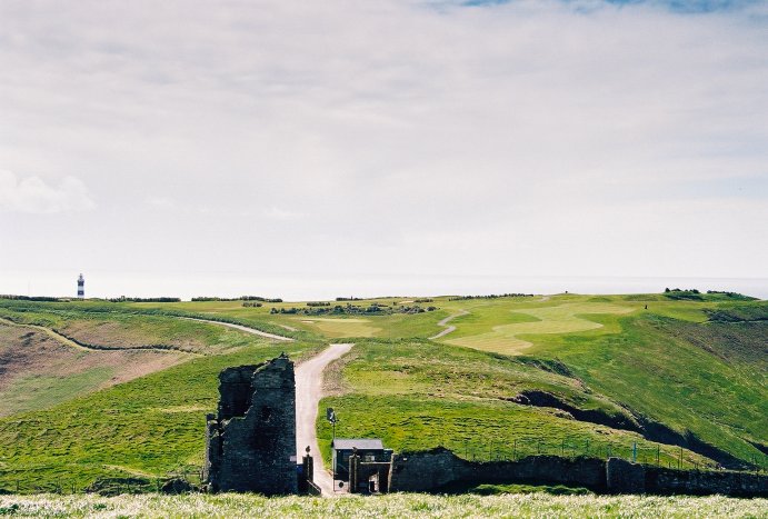
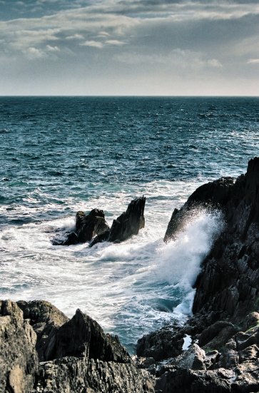
took the West Cork coast road (R600) and stopped at the Old Head of Kinsale.
This turned out to be quite a disappointment. It is the home of the very high
end Old Head
Golf Links and there is no way to get out to the actual Old Head. The owners
of the golf course have managed to block one of Ireland most spectacular coastal
areas and make it available only to those able to pony up the €250.00 it takes
to play the course. I had heard in
the past the locals were disappointed in losing access to the area, and I can
see why. If you travel here, you will be told that if you stand at the top of
the hill, well away from the paying customers, you will be able to see the
lighthouse in the distance. What a treat!
We
took the West Cork coast road (R600) and stopped at the Old Head of Kinsale.
This turned out to be quite a disappointment. It is the home of the very high
end Old Head
Golf Links and there is no way to get out to the actual Old Head. The owners
of the golf course have managed to block one of Ireland most spectacular coastal
areas and make it available only to those able to pony up the €250.00 it takes
to play the course. I had heard in
the past the locals were disappointed in losing access to the area, and I can
see why. If you travel here, you will be told that if you stand at the top of
the hill, well away from the paying customers, you will be able to see the
lighthouse in the distance. What a treat!
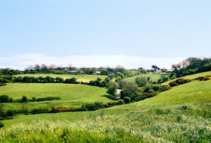
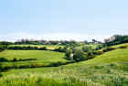 We
got back on the road through Timoleague and on to Clonakilty. This area deserves
serious exploration. P.J. MacCarthy, in his book McCarthy’s
Bar, covers this area extensively and hilariously and it is certainly a
picture postcard of rural Ireland. Green hills and valleys roll to the sea or to
the cliffs edge where the waves crash below. Southwest Cork is a spectacular
area and though not unknown to the tourists, certainly is off the trail and away
from the buses.
We
got back on the road through Timoleague and on to Clonakilty. This area deserves
serious exploration. P.J. MacCarthy, in his book McCarthy’s
Bar, covers this area extensively and hilariously and it is certainly a
picture postcard of rural Ireland. Green hills and valleys roll to the sea or to
the cliffs edge where the waves crash below. Southwest Cork is a spectacular
area and though not unknown to the tourists, certainly is off the trail and away
from the buses.
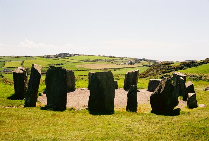
We
took the road to the Drombeg Stone Circle, which, by Irish standards is very
well marked, and found the circle easily. Again, you will find very few
visitors. As you approach, you find yourself in an unassuming area 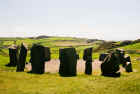 surrounded by
farmland. The stones themselves don’t appear remarkable and aren’t
particularly photogenic. They just are rocks sticking out of the ground. But
there is something more mystical about the area. Don’t get me wrong, I
don’t have a collection of crystals or a Ouija Board. Still, as you approach, you will likely experience a sense of
the past and of history that we who reside in “the New World” don’t often
enjoy. People often ponder the “feelings” they get when they visit the land
of their ancestors and it sometimes seems to get a little deep as people claim
to” feel the hand of the Celts touching their own”. Still, you can’t help
but be amazed at the passage of time as you stand at one of these sites. You
think back a month to all the fretting that your vacation was still
three weeks away and you didn’t think you could stand it, and now you are
pondering time in millennia instead of weeks. It’s a bit humbling.
surrounded by
farmland. The stones themselves don’t appear remarkable and aren’t
particularly photogenic. They just are rocks sticking out of the ground. But
there is something more mystical about the area. Don’t get me wrong, I
don’t have a collection of crystals or a Ouija Board. Still, as you approach, you will likely experience a sense of
the past and of history that we who reside in “the New World” don’t often
enjoy. People often ponder the “feelings” they get when they visit the land
of their ancestors and it sometimes seems to get a little deep as people claim
to” feel the hand of the Celts touching their own”. Still, you can’t help
but be amazed at the passage of time as you stand at one of these sites. You
think back a month to all the fretting that your vacation was still
three weeks away and you didn’t think you could stand it, and now you are
pondering time in millennia instead of weeks. It’s a bit humbling.
Glandore
is just up the road and has great potential as a jumping off point. We stopped
for a view of the bay and the majestic homes that enjoy the view that we had.
There are some lovely spots to have an afternoon snack but our plan was to drive
on to Castletownshend for lunch at Mary
Ann’s. This is a neat little pub in the middle of nowhere and a James
Joyce Pub award winner. Castletownshend is a narrow strip of a town and sits on
a slope overlooking the water. We had a baguette and some banoffee. For some
reason, this pie/pudding is associated with the Irish though it appears it was
“invented” at “The Hungry Monk” restaurant in East Sussex, England. It
blends banana and toffee in a caloric orgy, which will leave you waddling out of
the restaurant wondering how much abdominal torture you will have to inflict upon
yourself to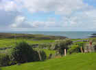 make up for this sin. Mary Ann's banoffee is as good as it gets, and
the portion size is obscene.
make up for this sin. Mary Ann's banoffee is as good as it gets, and
the portion size is obscene.
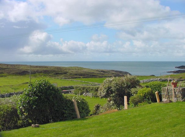
We
drove into Crookhaven
from there and found the Galley
Cove House after the most spectacular wrong turn of the trip, which took us
to the top of Brow Head. Unfortunately, there is no B&B at the top of the
hill, which commands a vertigo inducing view over the Mizen coast. We drove back
down the hill and over to the Galley Cove B&B.
To the right is the view from the front porch.
That
night, we enjoyed dinner at the Crookhaven
Inn. This is an amazing place with 4 star cuisine in a pub atmosphere. We were amazed at
what we were being served in this unassuming place. The locals don't know how
lucky they are. This is a small rustic pub with food served with elegant style
at reasonable prices. Complain if you will about Irish dining, but here, it was
fantastic.
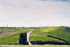
 After
dinner we decided that an evening drive would be in order so we headed out to
Three Castle Head. There is a small community out that way and you can take a moderately lengthy walk to the point, which we decided not to do because of the
lateness in the day. At the end of the road, there is a tiny cove that has a
ramp of some sort with a winch at the top to pull something up a very steep
incline. The cove looked a bit dangerous for landing any sort of small craft,
but I’m sure that it was done.
After
dinner we decided that an evening drive would be in order so we headed out to
Three Castle Head. There is a small community out that way and you can take a moderately lengthy walk to the point, which we decided not to do because of the
lateness in the day. At the end of the road, there is a tiny cove that has a
ramp of some sort with a winch at the top to pull something up a very steep
incline. The cove looked a bit dangerous for landing any sort of small craft,
but I’m sure that it was done.
With a long day behind us we
headed back for the Galley Cove. Our room was just high enough to see the light
from the Fastnet lighthouse warning ships away from it’s dangerous rocks. I
always find myself mesmerized by those distant lights that had to be a happy
sight for those who had been on the water for weeks at a time. Land was near.
More
Pictures
| Home
| Cahir | Kinsale
| Crookhaven
| Crookhaven
| Sneem |
Sneem | Dingle
| Dingle |
Doolin | Oranmore
| Boyle | Carrick
on Shannon | Roosky
| Lanesborough
| Lanesborough
| Shannonbridge
| Banagher
| Bunratty
| Map
|
 We
left the Cephas house to find our way to Charles
Fort, lost Millie and Bill, missed the turn, had to get turned around,
passed them going the other way, they missed the turn ...blah, blah, blah.
Kinsale is a busy town, even on a Saturday morning. We eventually found the
place. This is quite a remarkable building, and we got there early and had the
place almost all to ourselves. The views out to the harbor are awe-inspiring.
There was an Irish military ship stationed in the bay, which was in stark
contrast to the old stone fort. You have to figure that not only did the
designers realize the strategic importance of the site, but also must have said
“Nice view, let’s build a fort”. It’s easy to wander around the sight
and get lost or lose your travel companions, and I managed to do both. I
finally found them and myself back at the car.
We
left the Cephas house to find our way to Charles
Fort, lost Millie and Bill, missed the turn, had to get turned around,
passed them going the other way, they missed the turn ...blah, blah, blah.
Kinsale is a busy town, even on a Saturday morning. We eventually found the
place. This is quite a remarkable building, and we got there early and had the
place almost all to ourselves. The views out to the harbor are awe-inspiring.
There was an Irish military ship stationed in the bay, which was in stark
contrast to the old stone fort. You have to figure that not only did the
designers realize the strategic importance of the site, but also must have said
“Nice view, let’s build a fort”. It’s easy to wander around the sight
and get lost or lose your travel companions, and I managed to do both. I
finally found them and myself back at the car.