LOCATION
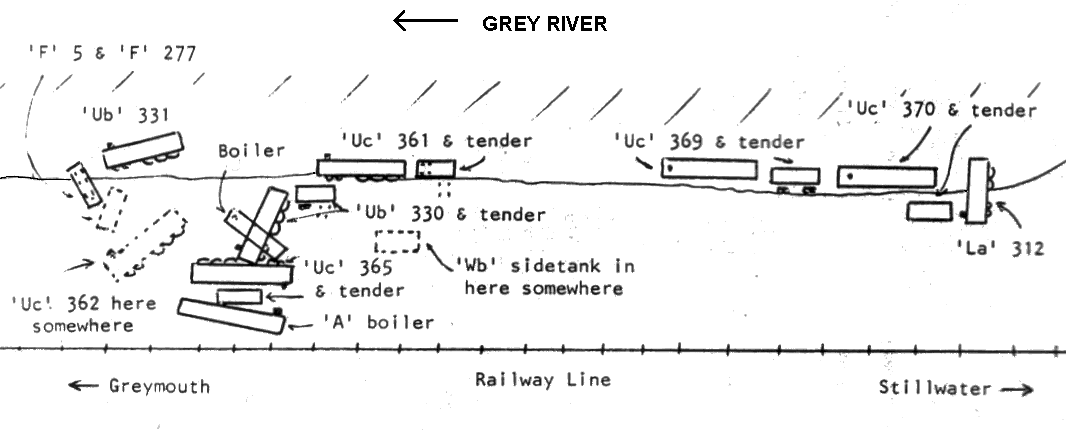
The map to the left shows
the approximate location of known locomotives at the Omotolocomotive dump
it was compiled by Mark Denne between 1982 & 1987. Since this map was
drawn La 312 and the 2 Uc's at the Stillwater end of the site have slipped
into the murky waters of the Grey River.
Getting to the Dump
Leave Greymouth travellign along the main road to Dobson. You follow the railway line all the way there, after going over the lumpy piece of road you are right next to the line, its here where the old viaduct was. Keep going till just past the windy road sign, looking to your left you will see the line below and a curved wooden bridge. Find a sutable parking place and follow instructions below.
Easy Way
This starts off the main road, park off the road, and look for a big pine tree towards Dobson. There is a track of sorts going down here, it even has steps and this takes you to the railway line., stay on the Dobson side of the bridge and go done the track made by a digger some time ago. then follow along the creek bed until you reach the river, then turn hard Right and walk up the river towards the race course. You can't miss the loco dump!
Hard Way
The hard way. Park your car on the Greymouth side of the site next to a concrete power pole. Clamber down the steep sited cliff onto the railway line. Walk along the railway line over the curved bridge this takes you to the Dobson side of the bridge. Go done the track made by a digger some time ago. then follow along the creek bed until you reach the river, then turn hard Right and walk up the river towards the race course. You can't miss the loco dump!
(This is called the hard way as it involves a very steep climb back up on to the road, whereas the easy way is via steps.)
NOTE: I have not shown how to access the site as it crosses private property owned by the New Zealand Railways Corporation. Also it can be a very mucky track down to the site, and one has to be weary if uncertain about the tides, as the whole area is tidal.
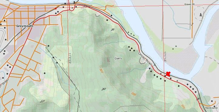
The
Omoto locomotive dump is situated approximatly 2 kilometres from Greymouth
between Greymouth and Stillwater. The map at the right shows the general
location of the locomotive dump, marked by a red X.
|
(C) Mark Denne 1982 |
Getting to the Dump
Leave Greymouth travellign along the main road to Dobson. You follow the railway line all the way there, after going over the lumpy piece of road you are right next to the line, its here where the old viaduct was. Keep going till just past the windy road sign, looking to your left you will see the line below and a curved wooden bridge. Find a sutable parking place and follow instructions below.
Easy Way
This starts off the main road, park off the road, and look for a big pine tree towards Dobson. There is a track of sorts going down here, it even has steps and this takes you to the railway line., stay on the Dobson side of the bridge and go done the track made by a digger some time ago. then follow along the creek bed until you reach the river, then turn hard Right and walk up the river towards the race course. You can't miss the loco dump!
Hard Way
The hard way. Park your car on the Greymouth side of the site next to a concrete power pole. Clamber down the steep sited cliff onto the railway line. Walk along the railway line over the curved bridge this takes you to the Dobson side of the bridge. Go done the track made by a digger some time ago. then follow along the creek bed until you reach the river, then turn hard Right and walk up the river towards the race course. You can't miss the loco dump!
(This is called the hard way as it involves a very steep climb back up on to the road, whereas the easy way is via steps.)
NOTE: I have not shown how to access the site as it crosses private property owned by the New Zealand Railways Corporation. Also it can be a very mucky track down to the site, and one has to be weary if uncertain about the tides, as the whole area is tidal.