!!! GEOCITIES IS CLOSING DOWN THIS SITE ON OCTOBER 26, 2009 !!!
Gun Battery Fire-Control Towers (Base-End Stations)
of the Portsmouth Harbor Defense Command
1942-1946
!!! GEOCITIES IS CLOSING DOWN THIS SITE ON OCTOBER 26, 2009 !!!
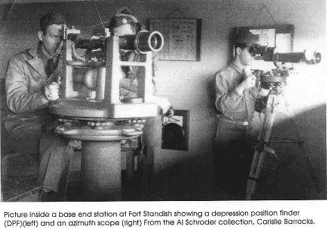
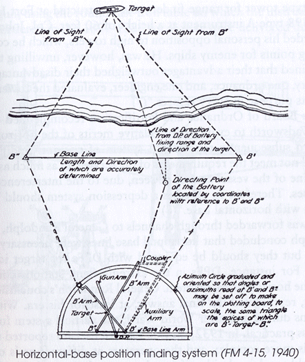
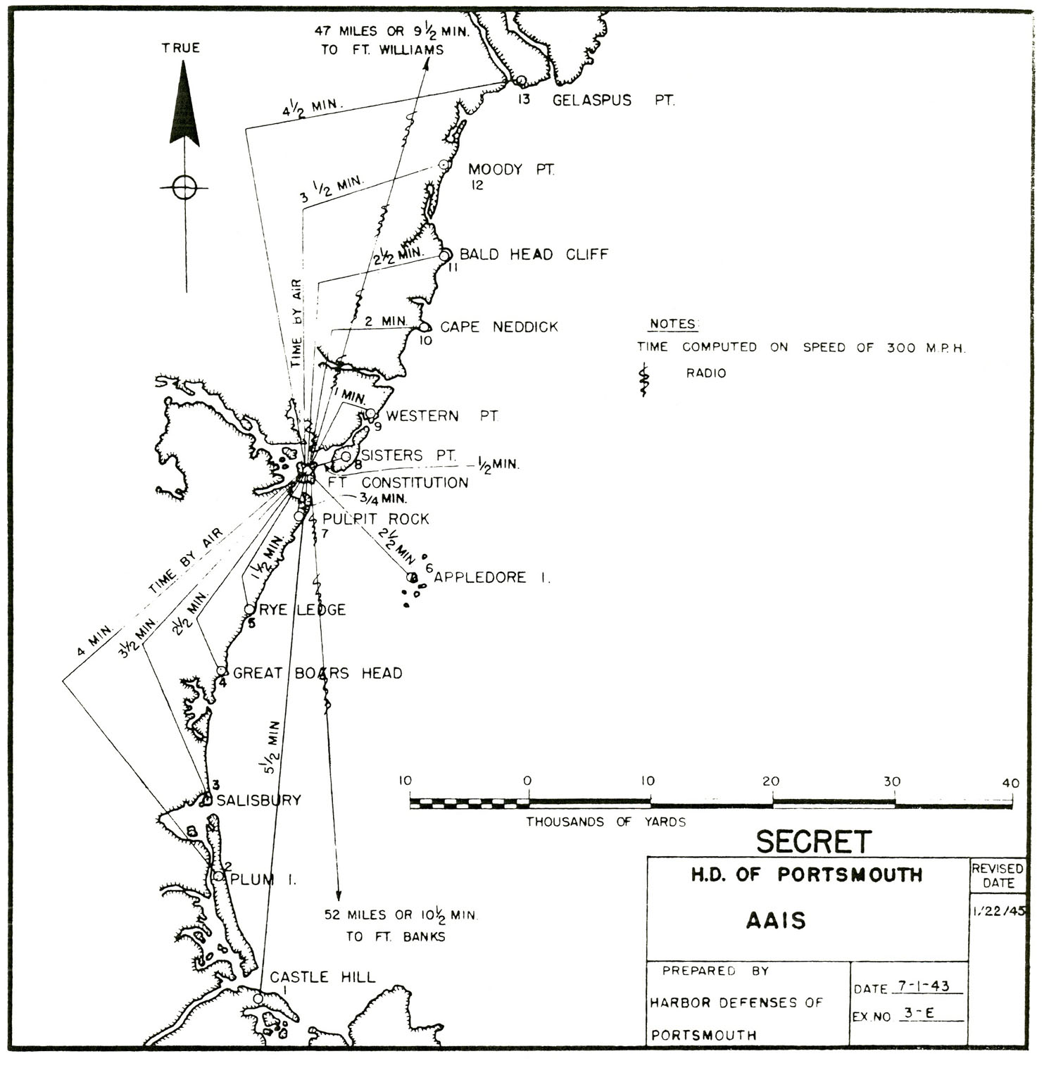
Sightings of surface ships made through the optical instruments at Base-End Stations were coordinated by time-interval bells that rang synchronously throughout the entire system. Using this method, the location of a target could be determined from several towers at the same instant. Data from these observers, along with weather and tidal information, was telephoned on secure lines to bomb-proof plotting rooms. A primitive computer, which had replaced the earlier manual plotting boards, processed all of the incoming information and then provided artillery crews with aiming coordinates based on the predicted location of the moving enemy ship at the time of firing. Because the shells might be fired as far as 25 miles, the rotation of the Earth also had to be taken into consideration when calculations were being made.
Each observation level in a station was used exclusively for one specific battery or command post, usually manned by six observers per level, and three observers for each AAIS station. Each station had a barracks, either attached or unattached to the tower itself, and was usually made to camouflage the structure (if attached) as a beach house or church or other such structure. Searchlight stations were manned by eight men per light, and shared the same barracks with the observation crews. Most stations were not manned during the later years of the war, as the threat of invasion ceased to exist, and also because the new invention of radar had made the towers obsolete as tracking stations. They were kept in service, however, to serve as a backup system to the radar. Fort Dearborn's two 16-inch guns were "mothballed" immediately after test-firing in 1944, therefore the stations assigned to these guns were actively manned only once in order to test the equipment. The stations assigned to Battery 205 at Fort Foster were never manned, as that battery was never armed and made operational.
Despite popular myths, the base-end stations were not submarine watch towers. They were long-range artillery aiming and tracking stations for use against enemy surface ships, and they also served as advance warning stations against enemy aircraft. (You cannot see a submerged submarine from a shore-based station! Naval aircraft and blimps were used to detect and locate the German U-boats.)
A note about station designations: B1 S1 (example) designates Base-End Station Number One, Spotting Station Number One (the full designation is correctly B1/1 S1/1, designating Base-End Station Number One and Spotting Station Number One for Tactical Gun Battery Number One); AAIS OP 1 (example) designates Anti-Aircraft Intelligence Service Observation Post Number One; HD OPS 1 (example) designates Harbor Defense Operations Station Number One. The tactical gun battery numbers assigned to Portsmouth in 1942 were as follows:
Tactical battery assignments for the personnel of the 22nd Coast Artillery Regiment (Harbor Defense) were as follows:
During and after World War I (1917 - 1921), there was an earlier system of emergency wartime base-end stations and fire-control observation posts. The main cupola of the Wentworth Hotel in New Castle was approved as an observation station for the Gun Group Commander at Fort Stark, although it is not known for certain whether it was actually used as such. A temporary wartime secondary field station (B" Battery Hunter, Fort Stark) was established on Odiorne Point in 1917. A concrete secondary station (B" Battery Hunter) was located about 300 yards east of the Wentworth Hotel. It was destroyed in 1998. A concrete secondary station still exists on Gerrish Island at Seward's Point (B" Battery Bohlen, Fort Foster). The primary stations (B') for Batteries Hunter, Bohlen, and Farnsworth (Fort Constitution) were located on post. The crow's nest positions on Battery Hunter (E1 Hunter - E2 Bohlen) and on Battery Bohlen (E1 Bohlen - E2 Hunter) were established as an improvised emergency baseline of approximately 2080 yards long until the advent of World War II rendered these stations obsolete.
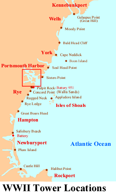
Individual Pages for Base-End Stations and other Sites:
Biddeford Pool Gun Battery
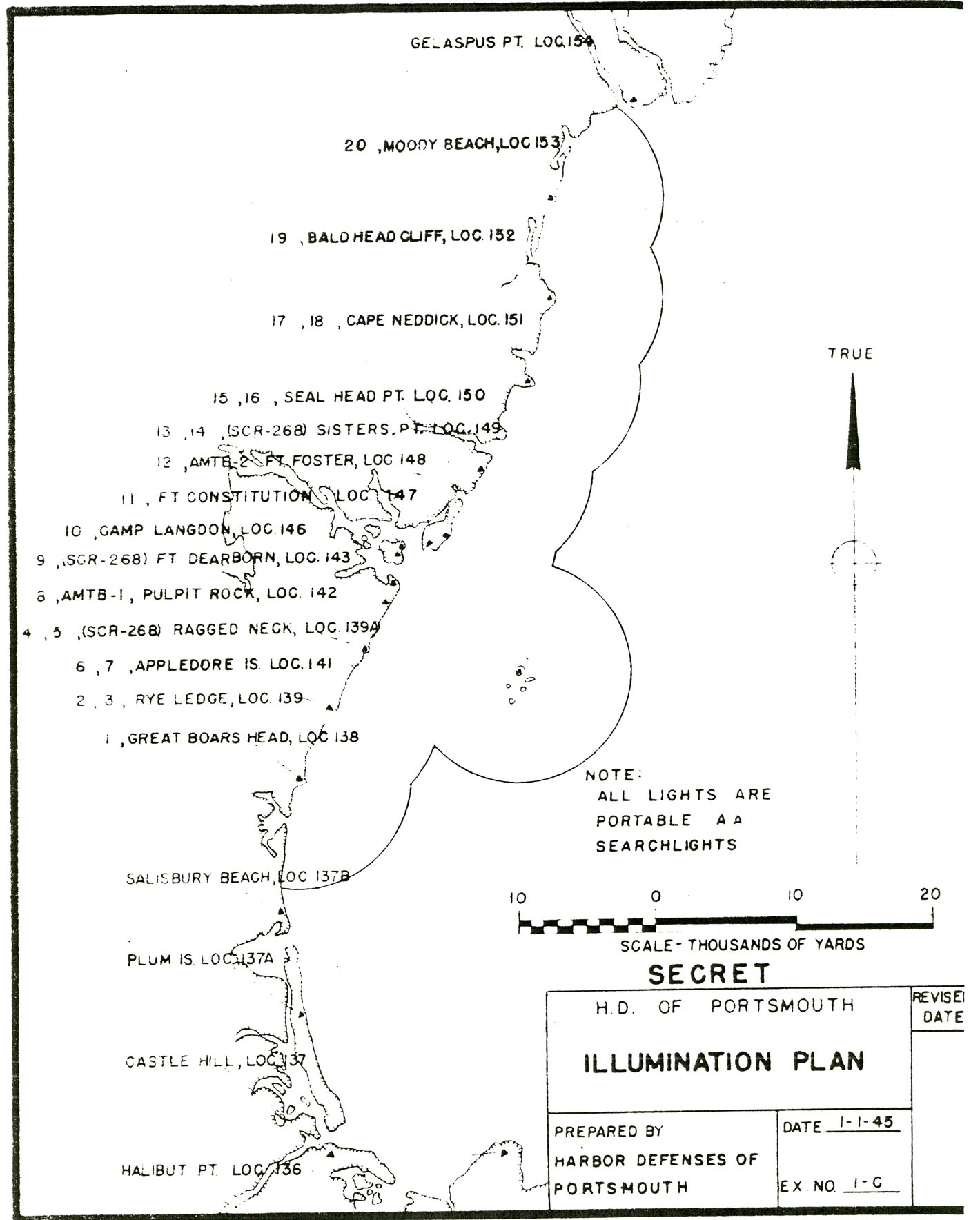
Gelaspus Point (Great Hill) Station
Moody Point Station
Bald Head Cliff Station
Mount Agamenticus Radar Station
Cape Neddick Station
Boon Island Coast Guard Station
Seal Head Point Station
Sister's Point Station
Seward's Point Station
Pulpit Rock Station
Appledore Island Station
Star Island Radar Station
Concord Point Radar Station
Ragged Neck Radar Station
Rye Ledge Station
Great Boars Head Station
Salisbury Beach Station and Gun Battery
Plum Island Station
Castle Hill Station
Halibut Point Station

HOME