Appledore Island Base-End / Radar Station - Location 141 (Site 1A)
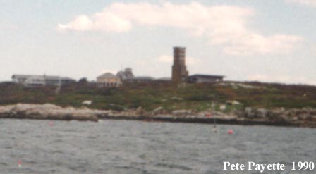
This seven-story tower was completed in April 1944 on a leased 1.94 acre site as a Base-End Station and Radar Station for Fort Dearborn. It is now owned by the Shoals Marine Laboratory of Cornell University. Searchlight positions #6 and #7 were located elsewhere on the island. To the north of the tower past the old USCG Boat House were the Army station barracks (Site 1B) and the Navy's Magnetic Indicator Loop Station along the gravel spall road to the Army-built crib wharf and pier (completed Sept. 1943). The Army pier was destroyed in a storm in 1947, and was never re-built.
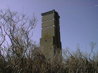
photo courtesy of J. Dennis Robinson of SeacoastNH.com 1998
A close-up of the Appledore Island tower. The seventh-story observation level (with DPF) was used for Battery Seaman (B7 S7), the sixth level was intended for Battery 205 (B2 S2), and the fifth level was for Battery 204 (B3 S3). The roof deck below the former SCR-296A radar antenna mast was for the anti-aircraft intelligence service (AAIS OP 6). The 50-foot tall steel mast for the radar unit that was on top of the tower was removed after the war. Three fuel tanks were installed directly underneath the tower. The concrete tower is no longer safe to enter, due to interior structural deterioration, but can be explored from the outside. All other military structures on the island no longer exist.Located on Appledore Island, Isles of Shoals, Kittery, Maine.
No Public Admittance!

WWII TOWERS HOME