Summary
A 7-Day Tour
of the
Montreal - Sherbrooke – Quebec Triangle
(June 2001)
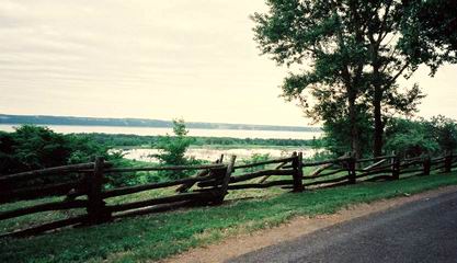
A View of the St. Lawrence River on the Chemin du Roy
Summary
This is a low energy circuit, mostly in the St. Lawrence Basin, passing
through Quebec’s four main cities (the fourth one is Trois-Rivières),
for a low budget vacation. Traveling alone with a complete camping gear
and a supreme luxury article – a mini espresso coffe maker, I completed this
800 km tour in 7 days. Except for some heavy rain on the last day, I had
perfect weather all the way.
|
Equipment
| - See
" Yet Another Bicycle
Tour of Southern France
" - My loaded bicycle weighted some 45 kg on departure day. - All prices are in Canadian dollars. |
Day by day
From Montreal to Sherbrooke through the countryside
Day 1
| Sunday,
June 24 - From Montreal to Racine (151 km, 12½ h) At 7 a.m., I was on my way to cross the St. Lawrence River on the bikeway link going trough Ste-Hélène and Notre-Dame Islands, and the St. Lawrence Seaway lock in Longueuil. Just as I was reaching the lift bridge of the lock, the gates were closing, and I was blocked there for more than one hour. Then, along came a short fellow on a bicycle. He told me that he was fishing carp in the Seaway. He was an ex-Cambodian soldier and POW who had been living in Montreal for some 20 years. Working in a downtown hospital, he was very critical of the public health care system, which, he said, was squandering millions on a bunch of wasted hoboes coming back every other week for expensive emergency care. “In my country, these people would be shot”, he said. He also resented the U.S.A., whose armed forces used his countrymen as pawns before dropping them entirely. Finally, the bridge was lowered, we said good bye and I was on my way. The day was cool and the sky was overcast, not bad for cycling. From Longueuil to Chambly, it is advisable to follow Highway 112 (Boulevard Cousineau in Longueuil), because long stretches of the bikeway are still under construction. The main (and only) charm of this endless suburban arterial is its convenient shoulder. The first 100 kilometers, crossing the St. Lawrence Basin, are a breeze. Past Chambly, I crossed the Richelieu River and, a few kilometers from Marieville, I switched to the old Chambly Road and I zipped on the Highway des champs, a cool, new bikeway, built on a decommissioned railroad right-of-way, going straight through the flat countryside to a point close to Granby. Two summer students patrolling the path were trying to convince those who didn’t have the annual tag ($10* - good for all the bikeways in Quebec) to buy one. In Granby, after crossing the Yamaska River, I intercepted la Granbyenne, a paved bikeway that runs along the river and Lake Boivin. Though crowded and full of skaters, it offers some interesting views, and is connected to a complete system of well-tended bikeways. After passing through the Yamaska Park, I turned north on la Campagnarde and then, taking the back roads, I headed for Racine (a small rural town on Highway 243), where I was expected. After a short stop in Valcourt (capital of the original Skidoos), I reached Racine as the sun was going down, at 8 p.m., just in time for dinner with my friends Édith, Richard, and their daughter Léa. This had been a very long day. |
Day 2
|
Monday, June 25 - From Racine to Sherbrooke (57 km, 6 h) That morning, the sun was shining. At 11 a.m., after a dip in the lake, my friends bade me bon voyage as I left for Sherbrooke. I took the chemin de la Grande Ligne, a narrow and hilly dirt road, and headed south. The view on the Orford Mountain and Park is spectacular. At the end of Lake Bowker, I turned left on the 220, a pleasant country road snaking up and down gentle hills and around beautiful lakes. Near Sherbrooke, I headed south for the Magog River, where I reached the quiet riverside bikeway (the Réseau cyclable des Grandes Fourches) that goes directly downtown. From there, it was easy for me to reach the eastern part of the city, where my friends Gérald and Renée were expecting me. |
Gliding on la Voie verte no. 1: from Sherbrooke to Quebec
Day 3
|
Tuesday, June 26 - From Sherbrooke to Princeville (115 km, 5 h) At 8 a.m., I headed north for Richmond, on the bikeway going down the St-François River. However, because of a 10 km gap just past Bromptonville, between the Réseau cyclable des Grandes Fourches and la Cantonnière, I had to take the old roller-coaster road on the eastern side of Highway 55, which offers nice panoramic views of the valley. I finally reached la Cantonnière, but before St-Grégoire-de-Greenlay, the path is so steep or full of gullies that I had to walk my bicycle at some places. Fortunately, from St-Grégoire to Richmond, the path, which follows the old road along the river, is quiet and pleasant. After pedaling some 46 km, I stopped in Richmond for a sandwich, and then hit the bikeway, another flat decommissioned railroad right-of-way, going through fields and forests straight to St-Rédempteur, just in front of the Quebec Bridge (142 km). The Highway verte no. 1 bikeway takes different names as you move on: la Cantonnière, les Corridors verts d’Asbestos, le Parc linéaire des Bois-Francs, le Parc linéaire de la MRC de Lotbinière, le Parc linéaire le Grand Tronc – don’t worry, it’s all the same. In Danville, I stopped at the Information booth to get the 2001 edition of the Quebec Campground Guide (free), but that office opens only on “from Thursday to Sunday”... I had more luck in Victoriaville, the administrative center. I lost some time looking for the tourist office, but I finally got one copy. Among other information), the guide lists all the campgrounds by region, with their phone numbers. By the way, you may rely on the written information of this guide, but the location of a campground on the map may be a crude approximation at best. If you don’t know where St-Whatchamacallit is, it’s safer to just phone and ask. In Victoriaville, the signs may be confusing in some places, particularly where the path crosses streets or split in two directions. Ask your way to make sure you’re heading in the right direction. people to make sure that you are on the right way. I decided to camp at the Plage des sables in Princeville, because there was no other alternative near the bikeway. Three kilometers before reaching the campground, I had a blow out. I stopped to repair it, but I had no spare. To locate the air leak in the tube, I stepped knee-deep into a ditch, but I hurt my bare heel on a sharp object. As if that wasn’t enough, when I tried to mend the tube, I realized that my glue tube was dry... Fortunately, a good Samaritan stopped, and offered to help me. He took my busted tube to a nearby motorcycle shop, on Highway 116, and brought it back to me some time later, with some cold water. I offered him $5, but he wouldn’t accept any money. Finally, I reached the campground at 7 p.m. ($10 for cyclists). I treated myself with hot pasta and cold rosé wine, and I slept very well. |
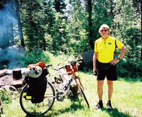
The Author in Racine
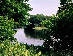
A View of St. François River
Day 4
|
Wednesday, June 27 - From Princeville to Beauport (133 km, 10 h) That morning, I had two things in mind. I stopped in Plessisville to get extra tubes and a patch kit, and then, I went to the dispensary to have my sore heel disinfected. After a couple of hours, the front desk clerk told me the doctor was late and would see me some time after lunch… I decided to move on: all things considered, my heel was hurting only when I was walking, not when I was pedaling. Back on the Parc linéaire, or whatever the name is, I was gliding through the fields and forests, just like in a dream. Except for a 20-km yet-to-be-built plain road stretch between nondescript Dosquet and St-Agapit, this ride was a piece of cake. The first thing I knew, by the end of the afternoon, I was crossing the Chaudière River, just in front of Quebec City. At that point, I had to decide where to cross the St. Lawrence River. I could have gone to Lévis to take the ferry, which lands in the Lower Town, but I wasn’t sure about the schedule (later, I learned that there is a ship every hour at that time of the year). So, to play it safe, I decided to take the bridge. A friend had told me that I could ride on the sidewalk on Pierre-Laporte Bridge, a modern suspension design (actually, he meant the Quebec Bridge - a classic cantilever bridge a few hundred meters eastward). My first problem was that there is no apparent way for a cyclist or a pedestrian to access Pierre-Laporte Bridge. Undaunted, I walked my bicycle up the concrete embankment to reach the bridge. Riding on the narrow band of concrete (not to be confused with a sidewalk) used for servicing the ubiquitous cables, I felt like a tightrope walker, but I didn’t want to go back. However, after a few hundred meters and a couple of rushing vans shaking me like an autumn leave, I got scared and stepped down. It took about 45 minutes to walk my bike across, but I felt much safer. On the other side, I zipped down the hill and hit Champlain Boulevard, which follows the river down the 100-meter cliff. I rode on the shoulder, which will soon be integrated into the bikeway system. When I reached the Vieux-Port, I switched to the bikeway snaking along the shore, until I reached the Montmorency Falls. I climbed the hill in front of Beauport and went straight up north. At 9 p.m., as the sun was going down, I reached the Beauport Municipal Campground, a nice and quiet place built in a wooded area close to the Montmorency River, with lots of available sites. I slept very well that night, too. |
Day 5
|
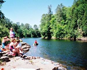
Thursday, June 28 - A Day off on the Montmorency River The next day was my day off. I went down the river to see the falls. At that time of the year, the water level is still high, and the view from above, on the footbridge, is terrific. Then I hiked along the river (which was left in its natural state) to bask in the sun and swim. I found a beautiful spot, with high banks of limestone sloping down in tiers, but it was completely littered with broken glass – hundreds of beer bottles must have been tossed there by the local morons. |
Riding the North Shore back to Montreal
Day 6
|
Friday, June 29 - From Beauport to Champlain (141 km, 12 h) The day was cool and cloudy. It was time to go back. I left early in the morning, and at 10 a.m., I was climbing the rue des Remparts. Using a map of Quebec City, I made my way eastward through the maze of narrow streets of the old walled city, until I reached the chemin St-Louis. Soon, I was in the Plaines d’Abraham Park, which offers a breath-taking view of the majestic river. Somewhere in Ste-Foy, I accidentally took boulevard Wilfrid-Laurier, where the traffic is really bad. After some impatient s.o.b. brush past me, I switched back to the chemin St-Louis, a quiet and pleasant street that used to be the main road. Around 10 a.m., I had breakfast in Cap-Rouge, right under the high perched railroad bridge. There are short stretches of bikeway here and there on the north shore, but most of the time, I rode on the Chemin du Roy (or Highway 138) going through small towns and fields, with occasional glimpses at the St. Lawrence River. This is a cool road for biking, now that Highway 40 channels the heavy intercity traffic. At 1 p.m., I had lunch in Deschambeault, a nice and well-preserved riverside town. There was some drizzle, but finally, the sun came out, and the ground was dry when I reached Champlain – you can call that luck. I stopped in a $10* camping on the river bank. |
Day 7
|
Saturday, June 30 - From Champlain to Montreal (173 km, 14 h) That morning, I awoke around 4 a.m. because my swollen heel was hurting (Achilles may have had an arrow problem with his heel, but, in my case, it turned out that the infection was caused by a record-sized wood splinter). Because the least uncomfortable thing to do was riding, I packed my things and one hour later, I was back on the road. At 6 a.m., I crossed the quiet streets of sleeping Trois-Rivières. In the middle of the afternoon, my energy was getting low. The day was warm and damp, and, as I was fighting a head wind, my average speed was only 13 km/h. Past Maskinongé, after one more blowout, I thought I’d had it. I decided to take a chance and cross to the south shore, because the wind couldn’t be worse there. I turned left to take the ferry in St-Ignace-de-Loyola. It proved to be a smart decision; from Sorel, I rode the 65 last kilometers alternating between the short stretches of bikeways and the shoulder of Highway 132, along the beautiful river. I had to stop for some time in Verchères when a violent storm broke out. Some 20 minutes later, I was back on the road, dodging the puddles. In Boucherville, I switched to Boulevard Marie-Victorin, then I took on St-Charles Avenue in Longueuil. In no time, I was crossing the river on the cyclable link. I had looped the loop. All in all, that was an easy ride. As the years go by, the various bikeway sections should improve gradually, eventually merging into a continuous network crisscrossing the whole country. But there is no need to wait: the fun is already there. Enjoy it! |
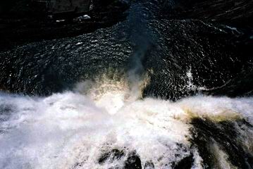
The Montmorency Falls from above
A View of Montmorency River
References