 |
A Short Tour of the Gaspé Peninsula
(September 2002) |
 |
|
|
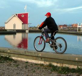
A Bold Young Cyclist in Matane
|
| |
A Short Tour of the Gaspé Peninsula
(September 2002) |
|
|
|
A Bold Young Cyclist in Matane
|
Introduction
| (Matane -
Forillon - Gaspé - Percé - Chaleur Bay
- Amqui - Matane - 900 km) As I always do before a bicycle trip, I searched the Web for relevant trip reports. That time, I ran out of luck: in the last thirty years, a lot of cyclists looped the loop around the Gaspé Peninsula, but few cared to write a comprehensive trip report. However, I found a few useful tips, like going around the Peninsula clockwise to take advantage of the tail wind (in Chaleur Bay, the mountains shelter the cyclists from the head wind). Well, here goes... by popular request, a day-by-day, detailed report of a great classic and technical challenge, the tour of the Gaspé Peninsula. I'll confess that, right from the start, my main motivation was pure vanity. I had just bought a snazzy, brand new Mikado 27-speed hybrid touring bicycle and told everybody that I intended to do the tour of the Gaspé Peninsula just to break it in. Talk about painting yourself into a corner! |
| Equipement :
See "Yet Another Tour of Southern France ". Loaded bicycle weight, 32.6 kg (72 lb), including 15.9 kg (35 lb) for the rear panniers, without the crew – 75 kg (166 lb), dressed. Accomodation : Hébergement Québec (Hotel, B & B and Youth Hostel Guide - Free ) Weather : I chose the beginning of September to avoid the heavy tourist affluence in high season. It was a gamble, because Gaspesia can be fairly cold or rainy past July or August. As it turned out, I got mixed weather, with temperatures ranging from 10 °C (early in the morning) to 29 °C (on sunny afternoons), with average temperatures of about 18 °C, which is just fine for long distance cycling. In retrospect, I am glad I didn't carry a complete camping gear because the weather wasn't appropriate, and any excess weight can be a serious handicap in the daunting hills of the northern shore. |
|
Day-by-day
Day 0 :
| Saturday,
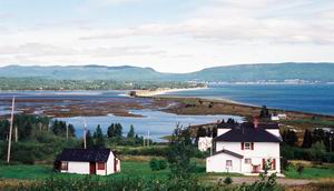
August 31 – From Montreal to Matane I went to bed early, but to no avail. My daughter, who had forgotten her keys, woke me up at 3 in the morning. I tried to go back to sleep, but then, the police staged a small raid in a parking lot nearby, because neighbors filed a complaint about wild sex parties going on in there - well, I guess living downtown has a price. So, I got up, started packing, and drove away at 7 a. m. As I got on Route 20, I picked up a backpacker hitchhiking there – which is strictly forbidden. Heading for the Gaspesia, he was very glad to get a direct lift from Montreal to Matane (640 km). He told me that, back in the 80s, he pedaled around the Gaspé Peninsula with two friends, camping all the way. He wouldn't do that today because he wasn't in shape anymore - yet, he was still under forty. We parted a few kilometers before Matane. Then, looking for a place to leave my car, I stopped at the "La Baleine" Camping Ground. The owner accepted $25 for 10 days. Because local B & B were booked for the Labour Day holiday, I rented a cheap room in La Marina motel ($44). There, I assembled my bicycle and went for a trial ride up and down Matane River, across a lavish municipal park (complete with assorted gardens, playgrounds and bicycle trails), built on the site of a former Price pulp and paper mill |
| Sunday,
September 1 – From Matane to St-Joachim-des-Tourelles (105 km, 6 h, av.
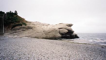
18.5 km/h) Early in the morning, on a cool, sunny day, I was riding nonchalantly on the soft shoulder of Route 132, with a brisk tail wind. Yet, despite the fact that the administrative limits of Gaspesia are somewhere between Rimouski and Matane, I didn’t get a feeling of the Gaspesia until I reached Capucines, a few kilometers from Cap-Chat. There, a pack of sleek, white, propeller-headed giants stand on the hills, with their huge three-bladed propellers rotating in accord once every three seconds - an eerie sight in an otherwise plain coastal scenery. A roadside park features a single megablade, some 30 meters long and about 2.5 meters wide at the base (100 x 8 feet). After a stop for hot dogs and fries in Cap-Chat, I was back on the road. I got bored of Route 132, which bypasses most small towns. From Les Méchins to Ste-Anne-des-Monts, I switched to the old coastal road. In the middle of the afternoon, I stopped at the Gîte de la Tour B & B in St-Joachim-des-Tourelles (now part of Ste-Anne-des-Monts). The owner, an old bloodshot-eyed man, gave me a warm welcome and offered me a cup of hot coffee. A little later, I went for a walk along the cliff, to visit the last standing natural turret-shaped rock (tourelle) on the shore, and a strange pierced rock with a loose round boulder on its top, standing on a cliff more than 30 meters (100 feet) above the shore. I ate in "Le Bon Accueil", a local restaurant offering a wide variety of generous but unsophisticated dishes of standard cuisine canadienne - whatever that means. Back in the B & B, I chatted for some time with the owner, a retired fisherman. The old man had a lot to tell about the local history and its changing economy for the last sixty years, back to the WW II years, when an RCAF base was built on Mount Jacques-Cartier (the highest peak of the Shick-Shocks, some 100 km inland), to search and destroy German submarines. Actually, the body count of our brave pilots also included an indeterminate number of fishing boats – "collateral damages". I went to bed early to put all the chances on my sides for the next day. |
Day 2

| Monday,
September 2 – From St-Joachim-des-Tourelles to Petite-Vallée
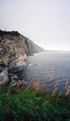
(115 km, 7 h, av. 19 km/h) On another cool and sunny day, with a 25 km/h tailwind, the air seemed still as I dashed on the sinuous flat road girdling the shores of the Gaspé Peninsula, at the foot of steep hills draped with dense forests, which cover most of the inner countryside. The majestic StLawrence River was draped in a thin veil of evanescent fog. Past Marsoui, I went by a rich collection of inukshuts (an Inuit word for a human-shaped cairn) erected by anonymous artists. The beautiful, flat stretch from Mont St-Pierre to Gros-Morne is a favorite for Sunday cyclists. In some places, for example in l'Anse-Pleureuse, due to the local geometry of the hills, the wind direction is reversed, and I had to fight a strong head wind. Everywhere else, the ride was so pleasant that I couldn't help wondering what had become of the narrow rural road snaking up and down the ragged coastline, which used to be the trademark of the Gaspesia on the postal cards of yesteryear. But my nostalgia bubble soon deflated just past Manche d'Épée where, after some 90 km of a relatively flat ride, I hit a first, middle-sized hill. Soon after, in Rivière-la-Madeleine, I stopped for lunch at the lighthouse, on a cliff dominating the sandy bay. Later, gritting my teeth, I tackled an incredible hill, the first of a cluster of four. In some places, I had to walk my loaded bicycle up the steepest parts (with 12-14 degree slopes at some points) to the beginning of the low grade part on top). Later, I dove down the mother of all hills to get enough momentum to hop over the last one. Was I glad to reach the panoramic viewpoint overlooking Grande-Vallée! I would have stopped in that town, but I had a reservation in Petite-Vallée, some 13 km farther. After going up and down a few more hills, I reached the Maison Lebreux, a small, cozy inn located on a flat, north-facing headland at the foot of the hills (there I got a room and two hot meals for $66). After watching the sun set on the windy shore, I had a delicious bouillabaisse (specialty of the house ) for dinner and slept like a rock. |
| Tuesday,
September 3 – From Petite Vallée to Cap-des-Rosiers (82 km, 6 h, av. 14 km/h) Hitting the road at 8:30 on another beautiful cool and sunny day, I needed some seven hours to cover the last 82 kilometers to Cap-des-Rosiers, on the very tip of the Peninsula. As I see it, the hilly part of Route 132 can be divided in three sections. Except for an isolated hill in Manche d'Épée, the first cluster stretches from Rivière-la-Madeleine to Grande Vallée (Day 3). Then, after a relatively smooth ride (at that point of the journey, if you survived, medium-size hills won't impress you anymore), get ready for the next pack, from Cloridorme to Rivière-au-Renard. I often had to step down after the first half of these monster hills. It's a good thing that I didn't know what stood ahead; false hopes are sometime better than no hope at all... As for the third cluster of hills, it is waiting for you just before Percé (Day 6). The last 20 kilometers of rolling hills, from Rivière-au-Renard to Cap-des-Rosiers weren't exactly a picnic, but the joy to have made it to the tip of the Peninsula provided ample compensation. It's a good thing I made a reservation in the only B & B in town ("Aux pétales de roses") the night before, because the small room I got ($30) was the last one. Built along the shore, this small town is a good place to stay. Besides its white lighthouse, there is an Internet café and a very good seafood restaurant, "Chez Mona". Back to the B & B, I chatted with other guests (a Swiss family) for a while and had a very good night's sleep. In the morning, I did my daily conditioning exercises, and felt much better afterward (Thanks to Les Increvables - see: Étirements ) |
Forillon - Gaspé - Percé
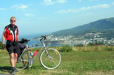
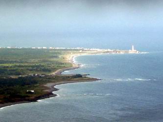
The Author in Grande-Vallée
| Wednesday,
September 4 - A day in Park Forillon (16 km, 1h) I took a day off to visit Forillon Park . No question about it, the thing to do would have been walking the 8-km trail going down to Cap-Gaspé, at the very tip of the Peninsula, but the misty weather would have spoiled much of the sightseeing and besides, I needed some rest. Nietzsche wrote: "That which does not kill me makes me stronger" – but he might have added "... though it makes me feel like a mess for the next few days." After a short stop in Cap Bon-Ami to enjoy the sights, the scents and the feeling of the wild, barren seashore - revamped by Parks Canada, I took the short-cut trail across the peninsula, to visit the mock historic fishermen village in Grande-Graves, in the Bay of Gaspé. There I learned everything there is to know about catching, dressing, salting and curing cod. On the way back, I took the trail going to the observation tower of Mount St. Alban, but the top was engulfed in low, damp clouds and there was not much to see. The rain broke out in the evening. |
Day 5
Park Forillon
| Thursday,
September 5 - From Cap-des-Rosiers to Gaspé (42 km, 2½ h, av. 16 km/h) Soon after I left at 8:30 a.m. in the morning, it was raining again. In the Gaspé Bay, when I started climbing the middle-sized hill just before Cap-aux-Os, I was already soaked through, but pedaling kept me warm. Fortunately, the rest of the stretch was easy, and around 11:30, I was in Gaspé. I went straight to the B & B I had called the evening before, but there was nobody home. I took refuge in the local Subway for the submarine sandwich and hot soup special, and to warm my bones as well. One hour later, I hit the same closed door. After a call at the Adams Motel on the main street ($52, a rip-off), I remembered that, while I was on the outskirts of the town, I had seen a sign announcing a B & B on Route 198. Soon after, I moved in Jolie-Vue B & B ($45), some 2 km from the town center. The owners, an elderly couple, told me a very sad story. Before the Forillon Park was created by the federal government at the beginning of the 70s, they owned an inn on Cap Bon-Ami (just where I has been the day before). The government agents put a compulsory purchase order on their property for a ridiculous price, and they had to trade their small piece of paradise for a plain house in Gaspé. There's worse : Park Canada tore down a perfectly good inn which, due to the limited accomodation capacity in Cap-des-Rosiers, would have attracted more tourists without spoiling the view, because the park is located inland. Then, I walked back to Gaspé for a sentimental journey, that started with a stop at the launderette of the Collège de la Gaspésie, where I taught chemistry for one year back in 1972. My next stop was at the Jacques Cartier Museum, built on a cliff with a terrific view of the Gaspé Bay, on the site of the small cottage where I lived then. In the museum, I learned a lot of interesting things about the brave pioneers who settled that cold and inhospitable land, and about Jacques Cartier, who claimed these lands for France in 1534. Was he the first European to visit that part of North America? Hardly; the Gaspé Bay had been known for decades by Basque fishermen (and it was probably visited by the Vikings a few centuries earlier), but it was such a good fishing spot that they kept the secret to themselves... In a café on the main street (la Brûlerie des Artistes), I met Randy, an environment consultant from British-Columbia doing contracted-out studies on endangered bird species. He insisted on speaking French with me – that was cool. |
Day 6
Gaspé Bay - 1
Gaspé Bay - 2
| Friday,
September 6 - From Gaspé to Percé (82 km, 5 h, av. 17
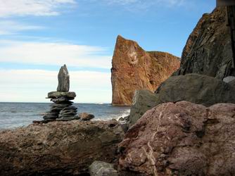
km/h) On yet another sunny and fresh morning, I was riding down the smooth road going around the Gaspé Bay, with a gentle wind blowing on my back. The first 40 kilometers of this short stretch are rather pleasant. Past Pointe-St-Pierre, the distinctive silhouette of the Percé Rock, near Bonaventure Island, looks like a huge anchored boat. Then, I had to fight a head wind up to Coin-du-Banc, before hitting a pack of three hills, some 10 km from Percé. On the top of the last one, I was rewarded by an incredible bird's eye view of the Percé Rock. After a steep descent, I was in Percé for lunch. I made a few calls and found a cozy room in Gîte de la Savoie. Soon after, I was paying a visit to an old friend, the majestic, variegated Percé Rock, but I had to stay on the shore because it was high tide. Later, sitting on the pier with anglers, I watched the golden light of the setting sun shining on Bonaventure Island ahead. |
Chaleur Bay and the Matapedia Valley
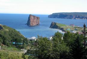
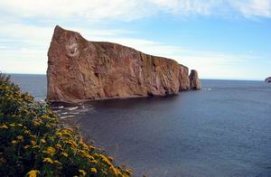
Percé and Bonaventure Island
The Percé Rock
| Saturday,
September 7 - From Percé to Bonaventure (136 km, 8¼ h,
av. 17 km/h) I left Percé at 8:30 a. m. and stopped in a nice municipal park at the top of Côte Surprise. There, I bade farewell to the Rock, basking in the misty morning light. I had finally traveled more than halfway, past a major psychological "point of no return". The early morning sun soon vanished. From Newport (where I stopped for lunch) to Port Daniel, Route 132 is more hilly and runs inside the lands. For a complete tour of the southern shore of Gaspé Peninsula, I should have followed, wherever possible, what's left of the old coastal road. However, the weather was getting lousy and I was afraid of getting caught by the rain, stranded in the middle of nowhere for a while. For that reason, I tried to cover as much distance as I could in one day, without making any reservation. From that point on, the front wind problems had completely disappeared. I was very satisfied with my new bicycle, which I had christened Vif-Argent (Quicksilver); it proved to be sturdy and very reliable all the way. Just past St-Godefroi, it started drizzling. I wanted to stop in New Carlisle, but I couldn't find any accommodation at a decent price. So, after a short break in a park featuring a life-size statue of René Lévesque, the local boy who put his town's name on the map, I decided to push on. The ride was easy, except that after a few hours on the road, I had to ride standing up on my pedals now and then, dancer style, to relieve my sore backside - happiness is a comfortable seat. Finally, as I was getting close to Bonaventure, I phoned ahead and found a place to stay at the Auberge du Café Acadien, close to the marina. For $65, I got a clean room and two meals, including fresh cod filets. I was the only guest. The young man tending the inn had projects and wanted to travel all over the world. We chatted and I whished him the best. |
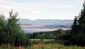
| Sunday,
September 8 - From Bonaventure to Pointe-à-la-Croix (120 km, 7 ¼ h, av. 17 km/h) No joy! The cool, damp and cloudy weather lasted all day. In some places where one can normally expect fine views of the sea, for instance in Carleton, Chaleur Bay almost disappeared in the clouds and mist. But I couldn't complain : the ride was relatively dry, except for some drizzle near Pointe-à-la-Garde. There, Jeff, a long-distance Australian cyclist, joined me for a dozen kilometers. Speaking an approximate French, that extraordinary guy told me his tale. Landing in Vancouver, he had already crossed Canada in 2½ months on his mountain bike, cutting across the Peninsula from Ste-Anne-des-Monts to Cascapedia, through the wild Parc national de la Gaspésie. He was now heading for the Maritime Provinces (including Newfoundland!) Carrying a complete camping equipment, he could travel up to 160 – 180 km per day. Thirty years old, huh? We parted at the grocery store in Pointe-à-la-Croix, where he took the bridge across the bay to Campbellton. As I was phoning to make a reservation, a woman walked up to me, saying that the grocery owner had just told her that I was looking for a B & B. I slept in La Maison Verte ($40), a big patrimonial house. |
Day 9
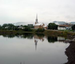
A Church in Carleton
| Monday,
September 9 - From Pointe-à-la-Croix to Amqui (101 km, 5½ h, av. 18 km/h) That day, I had to get to Amqui, just 100 km away – a piece of cake. From Pointe-à-la-Croix to Matapedia, Chaleur Bay tapers off to the size of a cow's creek – an anticlimactic sight in the grey and damp weather. Beyond that town, Route 132 makes a sharp turn northward to cross the Peninsula along Matapedia Valley but, for the next 40 km, there is no more shoulder. This is bad news, because van drivers are definitely not a cyclist's best friends. Despite the lousy weather, I enjoyed riding along the pristine-looking Matapedia River. That stretch is an easy ride, with fairly gentle slopes, except, maybe, in Causapscal. I took a break there, but I had to move on to fight the damp and cold weather. From Causapscal to Amqui, road works diverted all the traffic on a narrow country road. This is a worse case situation for a cyclist, especially when you can feel an angry diesel engine roaring in your back. I had to fall back on the bumpy gravel roadside to let them pass – very bad for the rims. Finally, I was in Amqui, where I found a cheap room ($30) in Hotel Amqui, a venerable wooden building with creaky floors, that probably didn't change much in the last 80 years. Watching the weather bulletin, it was a small comfort for me to learn that I had dodged the dog days afflicting the city dwellers. |
Day 10
| Tuesday,
September 10 - From Amqui back to Matane (72 km, 5h, av. 15 km/h) I was ready to set out at 7 a. m., but uh oh! - a flat tire. Then, while I was removing my back wheel, I noticed that it was severely out-of-true. I tried to change the broken spoke, but I didn't have the correct tool. I had neglected to check if I had all the required tools for my new bicycle - assumption is the mother of all screwups. After changing the punctured tube, I decided to take my chances with my buckled wheel and move on. I could probably have avoided that problem if, before I left, I had split the load in four panniers on both wheels, instead of only two on the rear wheel. From Amqui to St-René, I had to climb the short, steep hills of Route 195, a narrow, shoulderless country road. Fortunately, the traffic was light. When I reached Matane River, the ride got easy; I knew I had made it. Stopping in Matane, I almost fell face down because neither one of my newfangled clip shoes would unclip - I survived. Back to the camping ground, I crammed all my stuff inside my car and soon, I was on my way back. |
| I was glad to have successfully taken up one more challenge, but, to tell the truth, I didn't think much about the second half of the trip. If the weather had been nicer, I probably would have spent more time in Chaleur Bay to enjoy the place, probably in Carleton or in Miguasha . Some other time, I will. |